Location
Latitude: |
34-16-16.1000N (34.271139) |
Longitude: |
077-54-10.4000W (-77.902889) |
Elevation: |
31.7 feet MSL (10 m MSL) |
Magnetic Variation: |
9.6 W (as of April 2024 from WMM2020 model) |
Time Zone: |
UTC -5.0 (Standard Time) UTC -4.0 (Daylight Savings Time) |
From City: |
03 N.M. NE of Wilmington, North Carolina |
Found On: |
Charlotte Chart |
FAA Region: |
ASO |
Contacts
Manager: |
Publicly owned: |
| JEFFREY BOURK, A.A.E. 1740 AIRPORT BLVD WILMINGTON, NC 28405 910-341-4333 |
NEW HANOVER COUNTY 1740 AIRPORT BLVD WILMINGTON, NC 28405 910-341-4333 |
Operations
Airport Status: |
Operational |
Facility Use: |
Public |
Type: |
Airport |
Activation Date: |
07/1937 |
Control tower: |
Yes |
Attendance (Months/Days/Hours): |
Months/Days/Hours ALL/ALL/ALL |
Boundary ARTCC: |
ZDC (Washington) |
Responsible ARTCC: |
ZDC (Washington) |
Lighting Schedule: |
SEE RMK |
Traffic Pattern Altitude (MSL): |
1032 feet (315 m) |
NOTAMs Facility: |
ILM |
NOTAM-D Service: |
Yes |
International Airport of Entry: |
No |
Customs Landing Rights: |
Yes |
Military Landing Rights: |
Yes |
Civil/Military Joint Use: |
No |
Aircraft Rescue and Firefighting: |
Class I ARFF Index: B Air Carrier Service: Scheduled Certification Date: 05/1973 |
Based Aircraft
| Single Engine: | 67 |
| Multi Engine: | 11 |
| Jet Engine: | 21 |
| GA Helicopters: | 8 |
Annual Operations (as of 04/30/2023)
| Total Operations: | 81626 | |
| Commercial: | 14364 | 17.6% |
| Air Taxi: | 9783 | 12.0% |
| GA Local: | 15977 | 19.6% |
| GA Itinerant: | 31581 | 38.7% |
| Military Aircraft: | 9921 | 12.2% |
Communications
| CTAF: | 119.900 |
| Unicom: | 122.950 |
| Tower: | WILMINGTON 119.9 239.3 Hrs: 0600-2300 |
| Ground: | 121.9 348.6 |
| Approach: | WILMINGTON 118.25 ;164-343 135.75 ;344-163 284.65 ;164-343 317.425 ;344-163 Hrs: 0600-2300 WASHINGTON ARTCC Hrs: 2300-0600 |
| Departure: | WILMINGTON 118.25 ;164-343 135.75 ;344-163 284.65 ;164-343 317.425 ;344-163 Hrs: 0600-2300 WASHINGTON ARTCC Hrs: 2300-0600 |
| ATIS: | 124.975 Hrs: 24 |
| ASOS: | (910-254-5254) |
| TRSA: | 118.25 ;164-343 |
| VFR ADZY: | 239.3 |
| EMERG: | 243.0 |
| VFR ADZY: | 119.9 |
| EMERG: | 121.5 |
| TRSA: | 284.65 ;164-343 |
| TRSA: | 317.425 ;344-163 |
| TRSA: | 135.75 ;344-163 |
- APCH/DEP SVC PRVDD BY WASHINGTON ARTCC ON FREQS 124.025/269.15 (WILMINGTON RCAG) WHEN WILMINGTON APCH CTL CLSD.
- TWR PH #910-815-4530 X220.
Fixed Based Operators (FBOs) & Fuel
(Click on a business for detail)
Please help us keep this information up to date. This is a FREE SERVICE just like everything else on Airport Guide! If you see that a business needs to be added, modified, or deleted please fill out our Update Form.
To add, modify, or delete a business click here.
Please help us keep this information up to date. This is a FREE SERVICE just like everything else on Airport Guide! If you see that a business needs to be added, modified, or deleted please fill out our Update Form.
Area Code: 910 |
| Business Name | Frequency | Phone | Fuel Grade |
|---|---|---|---|
| Air Wilmington, Inc.
Update FBO info |
763-0146 | 100LL, Jet A | |
| AviatMall
Website Update FBO info |
Unicom 122.95 | 844-359-2456 | 100LL, Jet A |

|
AvFuel | 100LL - 6.25 USD per gallon on 7/15/14 |
Trucks Instant Fuel Discount available on 100LL or Jet-A inquire inside. |
|
|
AvFuel | Jet A - 5.76 USD per gallon on 7/15/14 |
Trucks Instant Fuel Discount available on 100LL or Jet-A inquire inside. |
Flight Service Stations
| Primary | Alternate | |
| FSS on Field: | N | |
| FSS Name (ID): | Raleigh(RDU) | |
| Frequency: | ||
| Toll Free Phone: | 1-800-WX-BRIEF |
Instrument Procedures / Charts
FAA Terminal Procedures valid from 0901Z 03/21/24 to 0901Z 04/18/24.
There are various types of charts available for an airport. They are listed in the Page Type column. Here is a legend for those types:
APD - Airport Diagram
DP - Departure Procedure Charts
HOT - Hot Spots
IAP - Instrument Approach Procedure Charts
MIN - Minimums
STAR - Standard Terminal Arrival Charts
| Page Type | Page Name | Volume | Action Since Last Cycle |
|---|---|---|---|
| APD | AIRPORT DIAGRAM | SE-2 | |
| HOT | HOT SPOT | SE-2 | |
| IAP | ILS Y OR LOC RWY 06 | SE-2 | |
| IAP | ILS Y OR LOC RWY 24 | SE-2 | |
| IAP | ILS Y OR LOC RWY 35 | SE-2 | |
| IAP | ILS Y RWY 24 (SA CAT I - II) | SE-2 | |
| IAP | ILS Z RWY 06 | SE-2 | |
| IAP | ILS Z RWY 24 | SE-2 | |
| IAP | ILS Z RWY 35 | SE-2 | |
| IAP | RNAV (GPS) RWY 06 | SE-2 | |
| IAP | RNAV (GPS) RWY 17 | SE-2 | |
| IAP | RNAV (GPS) RWY 24 | SE-2 | |
| IAP | RNAV (GPS) RWY 35 | SE-2 | |
| IAP | TACAN-A | SE-2 | |
| MIN | ALTERNATE MINIMUMS | SE-2 | |
| MIN | TAKEOFF MINIMUMS | SE-2 |
Terminal Procedures are only available for airports in several countries with more being added all the time. If you are looking for a specific country's charts, please send an email to support(at)airportguide.com stating the country name. This will be used to prioritize the implementation.
Navigation Aids (Navaids) near ILM
| Dist (NM) | ID | Morse Code | Name | Type | Freq | True Hdg | Mag Hdg |
|---|---|---|---|---|---|---|---|
| 5.0 | ILM | . . . _ . . _ _ | Wilmington | VORTAC | 117.00 | 16 | 26 |
| 5.1 | IL | . . . _ . . | Airli | NDB | 281 | 159 | 169 |
| 6.0 | GM | _ _ . _ _ | Wilze | NDB | 205 | 48 | 58 |
| 10.3 | CLB | _ . _ . . _ . . _ . . . | Carolina Beach | NDB | 216 | 196 | 206 |
| 28.5 | DIW | _ . . . . . _ _ | Dixon | NDB | 198 | 51 | 61 |
| 30.4 | OA | _ _ _ . _ | Ellas | NDB | 261 | 18 | 28 |
| 34.1 | TGQ | _ _ _ . _ _ . _ | Elizabethtown | NDB | 398 | 297 | 306 |
| 34.8 | NCA | _ . _ . _ . . _ | New River | TACAN | 115.40 | 41 | 51 |
| 40.1 | CPC | _ . _ . . _ _ . _ . _ . | Camp | NDB | 227 | 270 | 279 |
| 47.9 | CTZ | _ . _ . _ _ _ . . | Clinton | NDB | 412 | 331 | 341 |
| 48.1 | DKA | _ . . _ . _ . _ | Kenan | NDB | 332 | 359 | 369 |
| 49.2 | CRE | _ . _ . . _ . . | Grand Strand | VORTAC | 114.40 | 236 | 245 |
| 59.2 | IS | . . . . . | Stals | NDB | 276 | 9 | 19 |
| 60.6 | LBT | . _ . . _ . . . _ | Lumberton | VOR | 110.00 | 289 | 298 |
| 60.7 | EW | . . _ _ | Katfi | NDB | 362 | 41 | 51 |
| 60.9 | RSY | . _ . . . . _ . _ _ | Robeson | NDB | 359 | 290 | 299 |
| 63.3 | JB | . _ _ _ _ . . . | Jigel | NDB | 384 | 285 | 294 |
| 63.3 | NKT | _ . _ . _ _ | Cherry Point | TACAN | 112.80 | 52 | 62 |
| 63.9 | GSB | _ _ . . . . _ . . . | Seymour Johnson | TACAN | 116.50 | 356 | 366 |
| 64.1 | EWN | . . _ _ _ . | New Bern | VOR-DME | 113.60 | 41 | 51 |
Nearby Airports with Fuel
Notices to Airmen (NOTAMS)
Remarks
| A110-1 | FUEL: AIR WILMINGTON, INC, 910-763-4691 |
| A110-4 | BEARING STRENGTH RWY 06-24: ST175 |
| A110-5 | BEARING STRENGTH RWY 17-35: ST175 |
| A110-6 | FOR CD IF UNA TO CTC ON FSS FREQ, CTC WASHINGTON ARTCC AT 703-771-3587. |
| A16 | EXT 1001. |
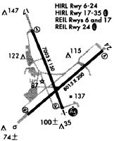
| A81-APT | ACTVT MALSR RWY 24 & 35; REIL RWY 06 & 17; PAPI RWY 06, 17, 24; HIRL RWY 06/24 & 17/35; AND ALL TWY LGTS - CTAF. |
| A86 | FSS-RALEIGH RDU-NOTAM ILM |
| E111 | TPA: ARPT IN EXISTENCE IN 1956. |
| E147 | TPA: 1000 FT AGL RECIPROCATING ENGINE, 1500 FT AGL TBJT/JET. OHD: 5 MILE INITIAL 2500 FT AGL, BREAK 2000 FT AGL. TOWER CALLS DRCTN OF BREAK. CARRIER BREAK NA. |
Runways
Runway Summary
| Runways: | 06/24 17/35 |
| Longest Runway: | 06/24 is 8016 ft (2443 m) long |
| Runways with an Instrument Approach: | 06, 24, 35 |
ILM Airport Runway Details
| Runway 06/24 | 8016 ft x 150 ft (2443 m x 46 m) | |
| Runway Length Source: | 3RD PARTY SURVEY as of 09/04/2015 | |
| Surface: | Asphalt - Good condition - Saw-cut or plastic grooved | |
| Runway Pavement Class: | 78 /F/B/W/T | |
| Runway Edge Lights: | High Intensity | |
Runway Weight Bearing Capacity (in thousands of pounds) |
||
| Single Wheel Landing Gear: | 75.0 | |
| Dual Wheel Landing Gear: | 160.0 | |
| Dual Tandem Wheel Landing Gear: | 275.0 | |
Runway 06 |
Runway 24 |
|
Elevation: |
21.0 | 20.2 |
Latitude: |
34-15-42.7828N | 34-16-35.4678N |
Longitude: |
077-54-37.1029W | 077-53-25.7206W |
|
Runway True Alignment: |
048 | 228 |
ILS Type: |
ILS/DME | ILS |
Glide Path Angle: |
3.0 degrees | 3.0 degrees |
Traffic Pattern: |
Left | Left |
Runway Markings Type: |
Precision Instrument | Precision Instrument |
Runway Markings Condition: |
Good | Good |
Visual Glide Slope Indicators: |
4-Light PAPI On Right Side Of Runway | 4-Light PAPI On Left Side Of Runway |
Runway Visual Range (RVR): |
Touchdown, Rollout | Touchdown, Rollout |
Approach Light System: |
1,400 Foot Medium Intensity Approach Lighting System With Runway Alignment Indicator Lights | |
REIL: |
Yes | No |
Touchdown Lights: |
No | No |
Threshold Crossing Height: |
57 | 48 |
Declared Distances |
||
Take Off Run Avbl. (TORA): |
8016 | 8016 |
Take Off Distance Avbl. (TODA): |
8016 | 8016 |
Actual Stop Dist. Avbl. (ASDA): |
8016 | 8016 |
Landing Dist. Avbl. (LDA): |
8016 | 8016 |
| Runway 17/35 | 7754 ft x 150 ft (2363 m x 46 m) | |
| Runway Length Source: | 3RD PARTY SURVEY as of 09/04/2015 | |
| Surface: | Asphalt - Good condition - Saw-cut or plastic grooved | |
| Runway Pavement Class: | 61 /F/B/W/T | |
| Runway Edge Lights: | High Intensity | |
Runway Weight Bearing Capacity (in thousands of pounds) |
||
| Single Wheel Landing Gear: | 60.0 | |
| Dual Wheel Landing Gear: | 185.0 | |
| Dual Tandem Wheel Landing Gear: | 300.0 | |
Runway 17 |
Runway 35 |
|
Elevation: |
30.9 | 18.3 |
Latitude: |
34-16-59.2576N | 34-15-47.5478N |
Longitude: |
077-54-36.0917W | 077-54-03.3195W |
|
Runway True Alignment: |
159 | 339 |
ILS Type: |
ILS | |
Glide Path Angle: |
3.0 degrees | 3.0 degrees |
Traffic Pattern: |
Left | Left |
Runway Markings Type: |
Precision Instrument | Precision Instrument |
Runway Markings Condition: |
Good | Good |
Visual Glide Slope Indicators: |
4-Light PAPI On Left Side Of Runway | 4-Light PAPI On Left Side Of Runway |
Runway Visual Range (RVR): |
Rollout | Touchdown |
Approach Light System: |
1,400 Foot Medium Intensity Approach Lighting System With Runway Alignment Indicator Lights | |
REIL: |
Yes | |
Threshold Crossing Height: |
50 | 36 |
Threshold Elevation: |
30.5 | 22.3 |
Displaced Threshold: |
350 | 400 |
Threshold Latitude: |
34-16-56.0207N | 34-15-51.2467N |
Threshold Longitude: |
077-54-34.6125W | 077-54-05.0098W |
Declared Distances |
||
Take Off Run Avbl. (TORA): |
7754 | 7754 |
Take Off Distance Avbl. (TODA): |
7754 | 7754 |
Actual Stop Dist. Avbl. (ASDA): |
6954 | 7604 |
Landing Dist. Avbl. (LDA): |
6604 | 7204 |
Services
Airframe Repair: |
Major |
Powerplant Repair: |
Major |
Bottled Oxygen: |
High Pressure / Low Pressure |
Bulk Oxygen: |
None |
Fuel Available: |
100LL, Jet A-1+ |
Landing Fees: |
No |
Parking: |
Hangars and tiedowns available |
Maps & Diagrams
ILM Sectional
Flight Planning
at skyvector.com
at skyvector.com