Location
Latitude: |
40-36-18.9000N (40.60525) |
Longitude: |
098-25-40.4000W (-98.427889) |
Elevation: |
1961.2 feet MSL (598 m MSL) |
Magnetic Variation: |
3.8 E (as of April 2024 from WMM2020 model) |
Time Zone: |
UTC -6.0 (Standard Time) UTC -5.0 (Daylight Savings Time) |
From City: |
02 N.M. NW of Hastings, Nebraska |
Found On: |
Omaha Chart |
FAA Region: |
ACE |
Contacts
Manager: |
Publicly owned: |
| MATTHEW KUHR 220 N. HASTINGS AVENUE HASTINGS, NE 68901-5144 402-984-5223 |
CITY OF HASTINGS 220 N. HASTINGS AVENUE HASTINGS, NE 68901-5144 402-984-5223 |
Operations
Airport Status: |
Operational |
Facility Use: |
Public |
Type: |
Airport |
Activation Date: |
04/1940 |
Control tower: |
No |
Attendance (Months/Days/Hours): |
Months/Days/Hours ALL/MON-FRI/0800-1700 |
Boundary ARTCC: |
ZMP (Minneapolis) |
Responsible ARTCC: |
ZMP (Minneapolis) |
Lighting Schedule: |
SEE RMK |
Segmented Circle Indicator: |
Yes |
Traffic Pattern Altitude (MSL): |
2961 feet (903 m) |
NOTAMs Facility: |
HSI |
NOTAM-D Service: |
Yes |
International Airport of Entry: |
No |
Customs Landing Rights: |
No |
Military Landing Rights: |
Yes |
Civil/Military Joint Use: |
No |
Based Aircraft
| Single Engine: | 26 |
| Multi Engine: | 5 |
Annual Operations (as of 04/27/2022)
| Total Operations: | 22700 | |
| Air Taxi: | 600 | 2.6% |
| GA Local: | 12000 | 52.9% |
| GA Itinerant: | 10000 | 44.1% |
| Military Aircraft: | 100 | 0.4% |
Communications
| CTAF: | 122.800 |
| Unicom: | 122.800 |
| ASOS: | 120.525 (402-463-4029) |
- APCH/DEP SVC PRVDD BY MINNEAPOLIS ARTCC ON FREQS 119.4/278.8 (HASTINGS RCAG).
Fixed Based Operators (FBOs) & Fuel
(Click on a business for detail)
Please help us keep this information up to date. This is a FREE SERVICE just like everything else on Airport Guide! If you see that a business needs to be added, modified, or deleted please fill out our Update Form.
To add, modify, or delete a business click here.
Please help us keep this information up to date. This is a FREE SERVICE just like everything else on Airport Guide! If you see that a business needs to be added, modified, or deleted please fill out our Update Form.
Area Code: 402 |
| Business Name | Frequency | Phone | Fuel Grade |
|---|---|---|---|
| Voyager Aviation
Update FBO info |
Unicom 122.8 | 461-3557, 462-4631 | 100LL, Jet A |
Flight Service Stations
| Primary | Alternate | |
| FSS on Field: | N | |
| FSS Name (ID): | Columbus(OLU) | |
| Frequency: | ||
| Toll Free Phone: | 1-800-WX-BRIEF |
Instrument Procedures / Charts
FAA Terminal Procedures valid from 0901Z 03/21/24 to 0901Z 04/18/24.
There are various types of charts available for an airport. They are listed in the Page Type column. Here is a legend for those types:
APD - Airport Diagram
DP - Departure Procedure Charts
HOT - Hot Spots
IAP - Instrument Approach Procedure Charts
MIN - Minimums
STAR - Standard Terminal Arrival Charts
| Page Type | Page Name | Volume | Action Since Last Cycle |
|---|---|---|---|
| IAP | RNAV (GPS) RWY 04 | NC-2 | |
| IAP | RNAV (GPS) RWY 14 | NC-2 | |
| IAP | RNAV (GPS) RWY 32 | NC-2 | |
| IAP | VOR RWY 14 | NC-2 | |
| IAP | VOR RWY 32 | NC-2 | |
| MIN | ALTERNATE MINIMUMS | NC-2 | |
| MIN | TAKEOFF MINIMUMS | NC-2 |
Terminal Procedures are only available for airports in several countries with more being added all the time. If you are looking for a specific country's charts, please send an email to support(at)airportguide.com stating the country name. This will be used to prioritize the implementation.
Navigation Aids (Navaids) near HSI
| Dist (NM) | ID | Morse Code | Name | Type | Freq | True Hdg | Mag Hdg |
|---|---|---|---|---|---|---|---|
| 0.1 | HSI | . . . . . . . . . | Hastings | VOR-DME | 108.80 | 240 | 236 |
| 5.4 | PSS | . _ _ . . . . . . . | Prosser | NDB | 338 | 335 | 331 |
| 16.9 | GR | _ _ . . _ . | Sancy | NDB | 380 | 17 | 13 |
| 23.3 | GRI | _ _ . . _ . . . | Grand Island | VOR-DME | 112.00 | 12 | 8 |
| 27.2 | EAR | . . _ . _ . | Kearney | VOR | 111.20 | 285 | 281 |
| 27.3 | EA | . . _ | Anoke | NDB | 422 | 272 | 268 |
| 39.2 | FMZ | . . _ . _ _ _ _ . . | Beklof | NDB | 392 | 91 | 88 |
| 40.8 | JYR | . _ _ _ _ . _ _ . _ . | York | NDB | 257 | 64 | 60 |
| 46.3 | OBH | _ _ _ _ . . . . . . . | Wolbach | DME | 112 | 4 | 0 |
| 47.1 | HJH | . . . . . _ _ _ . . . . | Hebron | NDB | 323 | 125 | 122 |
| 48.5 | TKO | _ _ . _ _ _ _ | Mankato | VORTAC | 109.80 | 170 | 166 |
| 59.2 | RPB | . _ . . _ _ . _ . . . | Republican | NDB | 414 | 143 | 139 |
| 61.8 | SWT | . . . . _ _ _ | Seward | NDB | 269 | 75 | 72 |
| 63.1 | FBY | . . _ . _ . . . _ . _ _ | Fairbury | NDB | 293 | 113 | 110 |
| 65.5 | ODX | _ _ _ _ . . _ . . _ | Ord | NDB | 356 | 339 | 335 |
| 66.5 | RRX | . _ . . _ . _ . . _ | Darr | NDB | 326 | 282 | 278 |
| 66.9 | PHG | . _ _ . . . . . _ _ . | Phillipsburg | NDB | 368 | 216 | 212 |
| 69.6 | BVN | _ . . . . . . _ _ . | Alaby | NDB | 332 | 13 | 9 |
| 70.6 | OLU | _ _ _ . _ . . . . _ | Columbus | VOR-DME | 111.80 | 43 | 40 |
| 71.4 | PLT | . _ _ . . _ . . _ | Platte Center | NDB | 407 | 41 | 38 |
Nearby Airports with Fuel
Notices to Airmen (NOTAMS)
Remarks
| A110-1 | FOR CD CTC MINNEAPOLIS ARTCC AT 651-463-5588. |
| A16 | ARPT CELL- MON-FRI 0800-1700 (402) 705-2420. |
| A57-04 | APCH RATIO 50:1 TO RWY THR. |
| A57-14 | APCH RATIO 48:1 DUE TO RR TWR 35 FT ABV & 1884 FT FM RWY END; 166 L. |
| A57-22 | APCH RATIO 50:1 TO RWY THR. |
| A57-32 | APCH RATIO FM DSPLCD THR 50:1. |
| A70-FUEL-A | FUEL INJECTION ADDITIVES AVBL. |
| A70-FUEL-10 | 0LL SELF-SVC FUEL AVBL 24 HRS. |
| A81-APT | ACTVT MIRL RYS 04/22 & 14/32 AND PAPI RYS 04/22 & 14/32 AND REIL RYS 14 & 32 - CTAF. |
Runways
Runway Summary
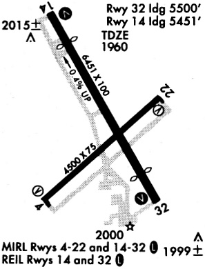
| Runways: | 04/22 14/32 |
| Longest Runway: | 14/32 is 6451 ft (1966 m) long |
| Runways with an Instrument Approach: |
HSI Airport Runway Details
| Runway 04/22 | 4501 ft x 75 ft (1372 m x 23 m) | |
| Runway Length Source: | 3RD PARTY SURVEY as of 07/12/2009 | |
| Surface: | Concrete - Good condition - No special surface treatment | |
| Runway Edge Lights: | Medium Intensity | |
Runway Weight Bearing Capacity (in thousands of pounds) |
||
| Single Wheel Landing Gear: | 36.0 | |
| Dual Wheel Landing Gear: | 47.0 | |
Runway 04 |
Runway 22 |
|
Elevation: |
1939.4 | 1947.5 |
Latitude: |
40-35-56.1912N | 40-36-26.6721N |
Longitude: |
098-26-01.6410W | 098-25-19.1561W |
|
Runway True Alignment: |
047 | 227 |
Glide Path Angle: |
3.0 degrees | 3.0 degrees |
Traffic Pattern: |
Left | Left |
Runway Markings Type: |
Nonprecision Instrument | Basic |
Runway Markings Condition: |
Good | Good |
Visual Glide Slope Indicators: |
2-Light PAPI On Left Side Of Runway | 2-Light PAPI On Left Side Of Runway |
Threshold Crossing Height: |
40 | 40 |
| Runway 14/32 | 6451 ft x 100 ft (1966 m x 30 m) | |
| Runway Length Source: | 3RD PARTY SURVEY as of 07/12/2009 | |
| Surface: | Concrete - Good condition - No special surface treatment | |
| Runway Edge Lights: | Medium Intensity | |
Runway Weight Bearing Capacity (in thousands of pounds) |
||
| Single Wheel Landing Gear: | 36.0 | |
| Dual Wheel Landing Gear: | 58.0 | |
| Dual Tandem Wheel Landing Gear: | 106.0 | |
Runway 14 |
Runway 32 |
|
Elevation: |
1961.2 | 1938.0 |
Latitude: |
40-36-51.7612N | 40-35-56.3918N |
Longitude: |
098-26-01.1492W | 098-25-19.7158W |
|
Runway True Alignment: |
150 | 330 |
Glide Path Angle: |
3.0 degrees | 3.0 degrees |
Traffic Pattern: |
Left | Left |
Runway Markings Type: |
Nonprecision Instrument | Nonprecision Instrument |
Runway Markings Condition: |
Good | Good |
Object at End: |
TOWER | ROAD |
Object Height: |
36 | 14 |
Distance from End: |
1884 | 364 |
Visual Glide Slope Indicators: |
4-Light PAPI On Left Side Of Runway | 4-Light PAPI On Right Side Of Runway |
REIL: |
Yes | Yes |
Threshold Crossing Height: |
38 | 42 |
Threshold Elevation: |
1939.6 | |
Displaced Threshold: |
950 | |
Threshold Latitude: |
40-36-04.5458N | |
Threshold Longitude: |
098-25-25.8161W | |
Declared Distances |
||
Take Off Run Avbl. (TORA): |
5500 | 6451 |
Take Off Distance Avbl. (TODA): |
6451 | 6451 |
Actual Stop Dist. Avbl. (ASDA): |
5500 | 6451 |
Landing Dist. Avbl. (LDA): |
5500 | 5500 |
Services
Airframe Repair: |
None |
Powerplant Repair: |
None |
Bottled Oxygen: |
None |
Bulk Oxygen: |
None |
Fuel Available: |
100LL, Jet A |
Landing Fees: |
No |
Parking: |
Hangars and tiedowns available |
Maps & Diagrams
HSI Sectional
Flight Planning
at skyvector.com
at skyvector.com