Location
Latitude: |
29-47-09.9000N (29.786083) |
Longitude: |
094-57-09.6000W (-94.952667) |
Elevation: |
33.8 feet MSL (10 m MSL) |
Magnetic Variation: |
1.6 E (as of April 2024 from WMM2020 model) |
Time Zone: |
UTC -6.0 (Standard Time) UTC -5.0 (Daylight Savings Time) |
From City: |
03 N.M. N of Baytown, Texas |
Found On: |
Houston Chart |
FAA Region: |
ASW |
Contacts
Manager: |
Privately owned: |
| CHARLES DANLEY 5600 BARKALOO ROAD BAYTOWN, TX 77521 713-303-8638 |
RACECO INC--BAYTOWN ARPT 5600 BARKALOO ROAD BAYTOWN, TX 77520 281-421-1671 |
Operations
Airport Status: |
Operational |
Facility Use: |
Public |
Type: |
Airport |
Activation Date: |
12/1958 |
Control tower: |
No |
Attendance (Months/Days/Hours): |
Months/Days/Hours ALL/ALL/0800-1700 |
Boundary ARTCC: |
ZHU (Houston) |
Responsible ARTCC: |
ZHU (Houston) |
Lighting Schedule: |
SEE RMK |
Segmented Circle Indicator: |
Yes |
Traffic Pattern Altitude (MSL): |
1034 feet (315 m) |
NOTAMs Facility: |
CXO |
NOTAM-D Service: |
Yes |
International Airport of Entry: |
No |
Customs Landing Rights: |
No |
Military Landing Rights: |
No |
Civil/Military Joint Use: |
No |
Based Aircraft
| Single Engine: | 32 |
| Multi Engine: | 12 |
| Jet Engine: | 2 |
| GA Helicopters: | 3 |
Annual Operations (as of 04/06/2023)
| Total Operations: | 21900 | |
| GA Local: | 10950 | 50.0% |
| GA Itinerant: | 10950 | 50.0% |
Communications
| CTAF: | 122.800 |
| Unicom: | 122.800 |
| Approach: | HOUSTON |
| Departure: | HOUSTON |
Fixed Based Operators (FBOs) & Fuel
(Click on a business for detail)
Please help us keep this information up to date. This is a FREE SERVICE just like everything else on Airport Guide! If you see that a business needs to be added, modified, or deleted please fill out our Update Form.
To add, modify, or delete a business click here.
Please help us keep this information up to date. This is a FREE SERVICE just like everything else on Airport Guide! If you see that a business needs to be added, modified, or deleted please fill out our Update Form.
Area Code: 281 |
| Business Name | Frequency | Phone | Fuel Grade |
|---|
Flight Service Stations
| Primary | Alternate | |
| FSS on Field: | N | |
| FSS Name (ID): | Montgomery County(CXO) | |
| Frequency: | ||
| Toll Free Phone: | 1-800-WX-BRIEF |
Instrument Procedures / Charts
FAA Terminal Procedures valid from 0901Z 03/21/24 to 0901Z 04/18/24.
There are various types of charts available for an airport. They are listed in the Page Type column. Here is a legend for those types:
APD - Airport Diagram
DP - Departure Procedure Charts
HOT - Hot Spots
IAP - Instrument Approach Procedure Charts
MIN - Minimums
STAR - Standard Terminal Arrival Charts
Terminal Procedures are only available for airports in several countries with more being added all the time. If you are looking for a specific country's charts, please send an email to support(at)airportguide.com stating the country name. This will be used to prioritize the implementation.
Navigation Aids (Navaids) near HPY
| Dist (NM) | ID | Morse Code | Name | Type | Freq | True Hdg | Mag Hdg |
|---|---|---|---|---|---|---|---|
| 9.3 | JPA | . _ _ _ . _ _ . . _ | Sanjac | NDB | 347 | 220 | 218 |
| 15.3 | EFD | . . . _ . _ . . | Ellington | TACAN | 109.40 | 225 | 223 |
| 17.9 | MHF | _ _ . . . . . . _ . | Trinity | VOR-DME | 114.75 | 143 | 141 |
| 18.5 | BVP | _ . . . . . . _ . _ _ . | Nixin | NDB | 326 | 312 | 310 |
| 18.6 | HUB | . . . . . . _ _ . . . | Hobby | VOR-DME | 117.10 | 245 | 243 |
| 19.0 | HOU | . . . . _ _ _ . . _ | Houston | VOT | 108.40 | 243 | 241 |
| 22.9 | IAH | . . . _ . . . . | Humble | VORTAC | 116.60 | 296 | 294 |
| 29.0 | GLS | _ _ . . _ . . . . . | Galveston | NDB | 206 | 159 | 157 |
| 29.0 | DAS | _ . . . _ . . . | Daisetta | VORTAC | 116.90 | 33 | 32 |
| 31.3 | VUH | . . . _ . . _ . . . . | Scholes | VOR-DME | 113.00 | 171 | 169 |
| 36.9 | EYQ | . _ . _ _ _ _ . _ | Weiser | NDB | 286 | 284 | 282 |
| 37.8 | DWH | _ . . . _ _ . . . . | David Hooks | NDB | 521 | 302 | 300 |
| 42.2 | GDE | _ _ . _ . . . | Goodhue | NDB | 368 | 65 | 64 |
| 44.4 | LB | . _ . . _ . . . | Freep | NDB | 263 | 217 | 215 |
| 47.3 | CX | _ . _ . _ . . _ | Alibi | NDB | 281 | 325 | 323 |
| 48.0 | SBI | . . . _ . . . . . | Sabine Pass | VOR-DME | 115.40 | 96 | 95 |
| 48.8 | HRD | . . . . . _ . _ . . | Hardin County | NDB | 524 | 47 | 46 |
| 49.7 | BPT | _ . . . . _ _ . _ | Beaumont | VOR-DME | 114.50 | 78 | 77 |
| 62.6 | ORG | _ _ _ . _ . _ _ . | Orange | NDB | 211 | 73 | 72 |
| 64.9 | TNV | _ _ . . . . _ | Navasota | VOR-DME | 115.90 | 297 | 295 |
Nearby Airports with Fuel
Notices to Airmen (NOTAMS)
Remarks
| A110*G | THIS AIRPORT HAS BEEN SURVEYED BY THE NATIONAL GEODETIC SURVEY. |
| A110-2 | FOR CD CTC HOUSTON APCH AT 281-443-5844 TO CNL IFR CALL 281-443-5888. |
| A16 | 713-303-8638 MGR CELL. |
| A57-14 | APCH SLOPE 11:1 TO DSPLCD THR OVR 76 FT TREES, 900 FT DSTC, 385 L. |
| A57-32 | APCH SLOPE 20:1 TO DSPLCD THR OVR 33 FT TREES, 463 FT DSTC, 260 FT L. |
| A58-14 | +15 FT RD 65 FT FM THR 250 FT L EXTDD CNTRLN; 6 FT FENCE FM 120 FT FM THR ACRS EXTDD CNTRLN. |
| A58-32 | 15 FT RD 0-199 FT DSTC FM 131 FT L - 185 FT R. |
| A81-APT | ACTVT REIL RWY 14 & 32; PAPI RWY 14 & 32; MIRL RWY 14/32 - CTAF. |
| E111 | PRE DATES THE ACT. |
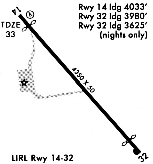
Runways
Runway Summary
| Runways: | 14/32 |
| Longest Runway: | 14/32 is 4334 ft (1321 m) long |
| Runways with an Instrument Approach: |
HPY Airport Runway Details
| Runway 14/32 | 4334 ft x 60 ft (1321 m x 18 m) | |
| Runway Length Source: | NGS as of 03/27/1998 | |
| Surface: | Asphalt - Good condition - No special surface treatment | |
| Runway Edge Lights: | Medium Intensity | |
Runway Weight Bearing Capacity (in thousands of pounds) |
||
| Single Wheel Landing Gear: | 24.0 | |
Runway 14 |
Runway 32 |
|
Elevation: |
33.8 | 27.4 |
Latitude: |
29-47-26.9800N | 29-46-52.8400N |
Longitude: |
094-57-24.5000W | 094-56-54.7290W |
|
Runway True Alignment: |
143 | 323 |
Glide Path Angle: |
3.0 degrees | 3.0 degrees |
Traffic Pattern: |
Left | Left |
Runway Markings Type: |
Nonprecision Instrument | Nonprecision Instrument |
Runway Markings Condition: |
Good | Good |
Object at End: |
ROAD | PLINE |
Object Height: |
15 | 20 |
Object Marked/Lighted?: |
Marked | |
Distance from End: |
201 | 200 |
Object Centerline Offset: |
131 ft. left of centerline | 0 ft. left and right of centerline |
Visual Glide Slope Indicators: |
2-Light PAPI On Left Side Of Runway | 2-Light PAPI On Left Side Of Runway |
REIL: |
Yes | Yes |
Threshold Crossing Height: |
20 | 20 |
Threshold Elevation: |
33.8 | 28.0 |
Displaced Threshold: |
786 | 721 |
Threshold Latitude: |
29-47-20.8000N | 29-46-58.5200N |
Threshold Longitude: |
094-57-19.1000W | 094-56-59.6800W |
Declared Distances |
||
Take Off Run Avbl. (TORA): |
4088 | 4003 |
Take Off Distance Avbl. (TODA): |
4088 | 4003 |
Actual Stop Dist. Avbl. (ASDA): |
4088 | 4003 |
Landing Dist. Avbl. (LDA): |
3320 | 3283 |
Services
Airframe Repair: |
Major |
Powerplant Repair: |
Major |
Fuel Available: |
100LL, Jet A |
Landing Fees: |
No |
Parking: |
Tiedowns available |
Maps & Diagrams
HPY Sectional
Flight Planning
at skyvector.com
at skyvector.com