Location
Latitude: |
40-28-52.3000N (40.481194) |
Longitude: |
107-13-03.6000W (-107.217667) |
Elevation: |
6606.3 feet MSL (2014 m MSL) |
Magnetic Variation: |
8.9 E (as of April 2024 from WMM2020 model) |
Time Zone: |
UTC -7.0 (Standard Time) UTC -6.0 (Daylight Savings Time) |
From City: |
02 N.M. SE of Hayden, Colorado |
Found On: |
Cheyenne Chart |
FAA Region: |
ANM |
Contacts
Manager: |
Publicly owned: |
| KEVIN BOOTH 11005 RCR 51A, PO BOX 1060 HAYDEN, CO 81639 970-276-5004 |
ROUTT COUNTY PO BOX 773598 STEAMBOAT SPRNGS 80477 970-879-0108 |
Operations
Airport Status: |
Operational |
Facility Use: |
Public |
Type: |
Airport |
Control tower: |
No |
Attendance (Months/Days/Hours): |
Months/Days/Hours ALL/ALL/0600-2000 |
Boundary ARTCC: |
ZDV (Denver) |
Responsible ARTCC: |
ZDV (Denver) |
Lighting Schedule: |
SEE RMK |
Segmented Circle Indicator: |
Yes |
Traffic Pattern Altitude (MSL): |
7606 feet (2318 m) |
NOTAMs Facility: |
HDN |
NOTAM-D Service: |
Yes |
International Airport of Entry: |
No |
Customs Landing Rights: |
No |
Military Landing Rights: |
Yes |
Civil/Military Joint Use: |
No |
Aircraft Rescue and Firefighting: |
Class I ARFF Index: C Air Carrier Service: Scheduled Certification Date: 05/1973 |
Based Aircraft
| Single Engine: | 9 |
| Multi Engine: | 5 |
| GA Helicopters: | 1 |
Annual Operations (as of 12/31/2022)
| Total Operations: | 16105 | |
| Commercial: | 5003 | 31.1% |
| Air Taxi: | 3152 | 19.6% |
| GA Local: | 1445 | 9.0% |
| GA Itinerant: | 6213 | 38.6% |
| Military Aircraft: | 292 | 1.8% |
Communications
| CTAF: | 123.000 |
| Unicom: | 123.000 |
| AWOS-3PT: | 119.275 (970-276-3690) |
- APCH/DEP CTL SVC PRVDD BY DENVER ARTCC (ZDV) ON FREQS 120.475/235.975 (HAYDEN RCAG).
- COMMUNICATIONS PRVDD BY DENVER RADIO ON FREQ 122.3 (HAYDEN RCO).
Fixed Based Operators (FBOs) & Fuel
(Click on a business for detail)
Please help us keep this information up to date. This is a FREE SERVICE just like everything else on Airport Guide! If you see that a business needs to be added, modified, or deleted please fill out our Update Form.
To add, modify, or delete a business click here.
Please help us keep this information up to date. This is a FREE SERVICE just like everything else on Airport Guide! If you see that a business needs to be added, modified, or deleted please fill out our Update Form.
Area Code: 970 |
| Business Name | Frequency | Phone | Fuel Grade |
|---|---|---|---|
| Spectrum Jet Center
Update FBO info |
Unicom 123.0 | 276-3743 | 100LL, Jet A |
Flight Service Stations
| Primary | Alternate | |
| FSS on Field: | N | |
| FSS Name (ID): | Denver(DEN) | |
| Frequency: | ||
| Toll Free Phone: | 1-800-WX-BRIEF |
Instrument Procedures / Charts
FAA Terminal Procedures valid from 0901Z 03/21/24 to 0901Z 04/18/24.
There are various types of charts available for an airport. They are listed in the Page Type column. Here is a legend for those types:
APD - Airport Diagram
DP - Departure Procedure Charts
HOT - Hot Spots
IAP - Instrument Approach Procedure Charts
MIN - Minimums
STAR - Standard Terminal Arrival Charts
| Page Type | Page Name | Volume | Action Since Last Cycle |
|---|---|---|---|
| IAP | ILS OR LOC RWY 10 | SW-1 | |
| IAP | RNAV (GPS) RWY 28 | SW-1 | Changed |
| IAP | RNAV (GPS) Y RWY 10 | SW-1 | |
| IAP | RNAV (RNP) Z RWY 10 | SW-1 | |
| IAP | VOR/DME-B | SW-1 | |
| MIN | ALTERNATE MINIMUMS | SW-1 | |
| MIN | TAKEOFF MINIMUMS | SW-1 |
Terminal Procedures are only available for airports in several countries with more being added all the time. If you are looking for a specific country's charts, please send an email to support(at)airportguide.com stating the country name. This will be used to prioritize the implementation.
Navigation Aids (Navaids) near HDN
| Dist (NM) | ID | Morse Code | Name | Type | Freq | True Hdg | Mag Hdg |
|---|---|---|---|---|---|---|---|
| 4.6 | CHE | _ . _ . . . . . . | Hayden | VOR-DME | 115.60 | 300 | 291 |
| 15.8 | BQZ | _ . . . _ _ . _ _ _ . . | Robert | VOR-DME | 112.20 | 93 | 84 |
| 40.8 | EKR | . _ . _ . _ . | Meeker | VOR-DME | 115.20 | 232 | 223 |
| 45.7 | RLG | . _ . . _ . . _ _ . | Kremmling | VOR-DME | 113.80 | 128 | 119 |
| 52.1 | SXW | . . . _ . . _ . _ _ | Snow | VOR-DME | 109.20 | 168 | 159 |
| 60.4 | SAA | . . . . _ . _ | Saratoga | NDB | 266 | 16 | 7 |
| 61.7 | RIL | . _ . . . . _ . . | Rifle | VOR-DME | 113.35 | 202 | 193 |
| 64.3 | DBL | _ . . _ . . . . _ . . | Red Table | VOR-DME | 113.00 | 166 | 157 |
| 77.9 | RDY | . _ . _ . . _ . _ _ | Sardy | TACAN | 114.30 | 167 | 158 |
| 78.2 | CKW | _ . _ . _ . _ . _ _ | Cherokee | VOR-DME | 115.00 | 347 | 338 |
| 79.4 | RWL | . _ . . _ _ . _ . . | Rawlins | VOR-DME | 109.40 | 0 | 351 |
| 85.1 | LAR | . _ . . . _ . _ . | Laramie | VOR-DME | 117.60 | 52 | 43 |
| 98.5 | MBW | _ _ _ . . . . _ _ | Medicine Bow | VOR-DME | 116.85 | 33 | 24 |
Nearby Airports with Fuel
Notices to Airmen (NOTAMS)
Remarks
| A110-1 | REQ ALL ACFT DEPG RWY 28 MAKE RGT OR LEFT TURNOUT AS SOON AS SAFETY PERMITS AFTER TAKEOFF TO AVOID TOWN OF HAYDEN & COMPLY WITH NOISE ABATEMENT PROCS. |
| A110-5 | LARGE FLOCKS OF SANDHILL CRANES AROUND ARPT IN SPRING AND FALL. |
| A110-6 | ALL ACFT REPORT 10 MINUTES PRIOR TO TKOF/LNDG ON 123.0 - MONITOR FREQ 24 HRS, PAEW ON RWY. |
| A110-7 | POSSIBLE SEVERE WINTER CONDITIONS FROM OCT-APR. CHECK NOTAMS FOR ARPT CONDITIONS. NO ARPT INFORMATION NOR SNOW REMOVAL GUARANTEED DURING HOURS OF NONATTENDANCE. |
| A110-9 | RWY 28 PAPI DOES NOT PROVIDE OBST CLEARANCE BEYOND 4.0 NM FROM THRESHOLD. |
| A24 | LANDING FEE FOR ACFT 12,500 LBS & OVER. |
| A26 | CLSD TO UNSKED ACR OPNS WITH MORE THAN 30 PSGR SEATS EXCP PPR; CALL UNICOM 970-819-1333. |
| A57-10 | OBSTRUCTION CLNC SLOPE 50:1 TO DSPLCD THLD. |
| A81-APT | ACTVT MALSF RWY 10; REIL RWY 28; PAPI RWY 10; HIRL RWY 10/28 - CTAF. |
| A82 | BTN 0600 - 2000 CTC UNICOM PRIOR TO ALL TKFS AND LNDGS FOR PAEW ADVISORIES. |
Runways
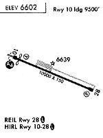
Runway Summary
| Runways: | 10/28 |
| Longest Runway: | 10/28 is 10000 ft (3048 m) long |
| Runways with an Instrument Approach: | 10 |
HDN Airport Runway Details
| Runway 10/28 | 10000 ft x 150 ft (3048 m x 46 m) | |
| Runway Length Source: | FAA OE/AAA as of 08/14/2014 | |
| Surface: | Asphalt - Good condition - Saw-cut or plastic grooved | |
| Runway Edge Lights: | High Intensity | |
Runway Weight Bearing Capacity (in thousands of pounds) |
||
| Single Wheel Landing Gear: | 75.0 | |
| Dual Wheel Landing Gear: | 170.0 | |
| Dual Tandem Wheel Landing Gear: | 260.0 | |
Runway 10 |
Runway 28 |
|
Elevation: |
6580.4 | 6606.2 |
Latitude: |
40-29-12.1257N | 40-28-32.3741N |
Longitude: |
107-14-02.8152W | 107-12-04.3827W |
|
Runway True Alignment: |
114 | 294 |
ILS Type: |
ILS/DME | |
Glide Path Angle: |
3.0 degrees | 3.5 degrees |
Traffic Pattern: |
Right | Left |
Runway Markings Type: |
Precision Instrument | Precision Instrument |
Runway Markings Condition: |
Good | Good |
Object at End: |
PLINE | |
Object Height: |
110 | |
Object Marked/Lighted?: |
Marked | |
Distance from End: |
3850 | |
Object Centerline Offset: |
0 ft. left and right of centerline | |
Visual Glide Slope Indicators: |
4-Light PAPI On Left Side Of Runway | 4-Light PAPI On Left Side Of Runway |
Approach Light System: |
1,400 Foot Medium Intensity Approach Lighting System With Sequenced Flashers | |
REIL: |
Yes | |
Threshold Crossing Height: |
52 | 54 |
Threshold Elevation: |
6583.7 | |
Displaced Threshold: |
510 | |
Threshold Latitude: |
40-29-10.0974N | |
Threshold Longitude: |
107-13-56.7743W | |
Declared Distances |
||
Take Off Run Avbl. (TORA): |
10000 | 10000 |
Take Off Distance Avbl. (TODA): |
10000 | 10000 |
Actual Stop Dist. Avbl. (ASDA): |
10000 | 10000 |
Landing Dist. Avbl. (LDA): |
9490 | 10000 |
Services
Airframe Repair: |
Major |
Powerplant Repair: |
Major |
Bottled Oxygen: |
None |
Bulk Oxygen: |
None |
Fuel Available: |
100LL, Jet A, MOGAS |
Landing Fees: |
No |
Parking: |
Tiedowns available |
Maps & Diagrams
HDN Sectional
Flight Planning
at skyvector.com
at skyvector.com