Location
Latitude: |
39-31-15.7000N (39.521028) |
Longitude: |
075-43-25.2000W (-75.723667) |
Elevation: |
69.9 feet MSL (21 m MSL) |
Magnetic Variation: |
11.5 W (as of April 2024 from WMM2020 model) |
Time Zone: |
UTC -5.0 (Standard Time) UTC -4.0 (Daylight Savings Time) |
From City: |
05 N.M. N of Middletown, Delaware |
Found On: |
Washington Chart |
FAA Region: |
AEA |
Contacts
Manager: |
Privately owned: |
| RALPH KUNZ 4200 SUMMIT BRIDGE ROAD MIDDLETOWN, DE 19709 302-834-5400 |
GREENWICH AEROGROUP 4200 SUMMIT BRIDGE ROAD MIDDLETOWN, DE 19709 302-834-5400 |
Operations
Airport Status: |
Operational |
Facility Use: |
Public |
Type: |
Airport |
Activation Date: |
09/1956 |
Control tower: |
No |
Attendance (Months/Days/Hours): |
Months/Days/Hours ALL/ALL/0700-1900 |
Boundary ARTCC: |
ZDC (Washington) |
Responsible ARTCC: |
ZNY (New York) |
Lighting Schedule: |
SEE RMK |
Segmented Circle Indicator: |
Yes |
Traffic Pattern Altitude (MSL): |
1070 feet (326 m) |
NOTAMs Facility: |
MIV |
NOTAM-D Service: |
Yes |
International Airport of Entry: |
No |
Customs Landing Rights: |
No |
Military Landing Rights: |
No |
Civil/Military Joint Use: |
No |
Based Aircraft
| Single Engine: | 21 |
Annual Operations (as of 12/31/2022)
| Total Operations: | 25500 | |
| GA Local: | 15300 | 60.0% |
| GA Itinerant: | 10100 | 39.6% |
| Military Aircraft: | 100 | 0.4% |
Communications
| CTAF: | 122.725 |
| Unicom: | 122.725 |
| Approach: | PHILADELPHIA 118.35 118.35 |
| Departure: | PHILADELPHIA 118.35 118.35 |
| AWOS-3: | 132.325 (302-378-2063) |
- CLEARANCE DELIVERY PHILADELPHIA APCH TF 800-354-9884.
Fixed Based Operators (FBOs) & Fuel
(Click on a business for detail)
Please help us keep this information up to date. This is a FREE SERVICE just like everything else on Airport Guide! If you see that a business needs to be added, modified, or deleted please fill out our Update Form.
To add, modify, or delete a business click here.
Please help us keep this information up to date. This is a FREE SERVICE just like everything else on Airport Guide! If you see that a business needs to be added, modified, or deleted please fill out our Update Form.
Area Code: 302 |
| Business Name | Frequency | Phone | Fuel Grade |
|---|---|---|---|
| Summit Aviation, Inc.
Website Update FBO info |
834-5400, 800-441-9343 | 100LL, Jet A |
Flight Service Stations
| Primary | Alternate | |
| FSS on Field: | N | |
| FSS Name (ID): | Millville(MIV) | |
| Frequency: | ||
| Toll Free Phone: | 1-800-WX-BRIEF |
Instrument Procedures / Charts
FAA Terminal Procedures valid from 0901Z 03/21/24 to 0901Z 04/18/24.
There are various types of charts available for an airport. They are listed in the Page Type column. Here is a legend for those types:
APD - Airport Diagram
DP - Departure Procedure Charts
HOT - Hot Spots
IAP - Instrument Approach Procedure Charts
MIN - Minimums
STAR - Standard Terminal Arrival Charts
| Page Type | Page Name | Volume | Action Since Last Cycle |
|---|---|---|---|
| IAP | NDB-A | NE-3 | |
| IAP | RNAV (GPS) RWY 17 | NE-3 | |
| IAP | RNAV (GPS) Y RWY 35 | NE-3 | |
| IAP | RNAV (GPS) Z RWY 35 | NE-3 | |
| MIN | ALTERNATE MINIMUMS | NE-3 | |
| MIN | TAKEOFF MINIMUMS | NE-3 |
Terminal Procedures are only available for airports in several countries with more being added all the time. If you are looking for a specific country's charts, please send an email to support(at)airportguide.com stating the country name. This will be used to prioritize the implementation.
Navigation Aids (Navaids) near EVY
| Dist (NM) | ID | Morse Code | Name | Type | Freq | True Hdg | Mag Hdg |
|---|---|---|---|---|---|---|---|
| 6.2 | IL | . . . _ . . | Hadin | NDB | 248 | 54 | 66 |
| 10.9 | DQO | _ . . _ _ . _ _ _ _ | Dupont | VORTAC | 114.00 | 29 | 41 |
| 17.7 | APG | . _ . _ _ . _ _ . | Aberdeen | NDB | 349 | 273 | 284 |
| 19.9 | ENO | . _ . _ _ _ | Smyrna | VORTAC | 111.40 | 150 | 162 |
| 20.6 | OOD | _ _ _ _ _ _ _ . . | Woodstown | VORTAC | 112.80 | 70 | 82 |
| 21.0 | PPM | . _ _ . . _ _ . _ _ | Phillips | VOR-DME | 108.40 | 261 | 272 |
| 23.9 | MXE | _ _ _ . . _ . | Modena | VORTAC | 113.20 | 5 | 17 |
| 26.2 | DOV | _ . . _ _ _ . . . _ | Dover | TACAN | 110.00 | 152 | 164 |
| 28.0 | RNB | . _ . _ . _ . . . | Rainbow | NDB | 363 | 102 | 114 |
| 30.6 | PHL | . _ _ . . . . . . _ . . | Philadelphia | VOT | 109.80 | 47 | 59 |
| 35.0 | VCN | . . . _ _ . _ . _ . | Cedar Lake | VOR-DME | 115.20 | 88 | 100 |
| 41.5 | ING | . . _ . _ _ . | Ambler | NDB | 275 | 28 | 40 |
| 42.7 | PTW | . _ _ . _ . _ _ | Pottstown | VORTAC | 116.50 | 10 | 22 |
| 44.1 | IUB | . . . . _ _ . . . | Institute | NDB | 404 | 251 | 262 |
| 44.4 | LRP | . _ . . . _ . . _ _ . | Lancaster | VOR-DME | 117.30 | 324 | 335 |
| 47.1 | PNE | . _ _ . _ . . | North Philadelphia | VOR | 112.00 | 44 | 56 |
| 48.3 | BAL | _ . . . . _ . _ . . | Baltimore | VORTAC | 115.10 | 244 | 255 |
| 48.9 | ATR | . _ _ . _ . | Waterloo | VOR-DME | 112.60 | 150 | 162 |
| 49.9 | SIE | . . . . . . | Sea Isle | VORTAC | 114.80 | 120 | 132 |
| 50.8 | FND | . . _ . _ . _ . . | Ellicott | NDB | 371 | 254 | 265 |
Nearby Airports with Fuel
Notices to Airmen (NOTAMS)
Remarks
| A110*G | THIS AIRPORT HAS BEEN SURVEYED BY THE NATIONAL GEODETIC SURVEY. |
| A110-2 | EXTSV MED/HVY HEL TRNG IN PROG ALL HRS ON & INVOF ARPT; HIGH ROTOR DOWNWASH VELOCITIES. WHEN CH47 HELICOPTERS OPERATING, REQUEST ADVISORIES ON UNICOM. |
| A110-3 | FOR CD CTC PHILADELPHIA APCH AT 800-354-9884. |
| A110-4 | RWY 11/29 CLSD FOR NIGHT OPS. |
| A40-11/29 | LIRL RY 11/29 OTS INDEFLY. |
| A48-11 | REIL RY 11 & RY 29 OTS INDEFLY. |
| A81-APT | ACTVT LIRL & REILS RY 11/29 - 123.5. |
| E111 | EXISTED PRIOR TO 1959 |
Runways
Runway Summary
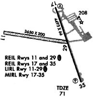
| Runways: | 11/29 17/35 |
| Longest Runway: | 17/35 is 4488 ft (1368 m) long |
| Runways with an Instrument Approach: |
EVY Airport Runway Details
| Runway 11/29 | 3601 ft x 200 ft (1098 m x 61 m) | |
| Runway Length Source: | NGS as of 10/17/2005 | |
| Surface: | Turf - Good condition - No special surface treatment | |
| Runway Edge Lights: | Low Intensity | |
Runway 11 |
Runway 29 |
|
Latitude: |
39-31-20.9900N | 39-31-16.2000N |
Longitude: |
075-44-02.5400W | 075-43-17.0000W |
|
Runway True Alignment: |
098 | 278 |
Glide Path Angle: |
0.0 degrees | 0.0 degrees |
Object at End: |
TREE | |
Object Height: |
42 | |
Distance from End: |
420 | |
Object Centerline Offset: |
70 ft. left of centerline | |
REIL: |
Yes | Yes |
| Runway 17/35 | 4488 ft x 65 ft (1368 m x 20 m) | |
| Runway Length Source: | NGS as of 10/17/2005 | |
| Surface: | Turf - Good condition - No special surface treatment | |
| Runway Edge Lights: | Medium Intensity | |
Runway 17 |
Runway 35 |
|
Elevation: |
64.9 | 64.8 |
Latitude: |
39-31-34.8200N | 39-30-51.9853N |
Longitude: |
075-43-20.9826W | 075-43-06.1278W |
|
Runway True Alignment: |
165 | 345 |
Glide Path Angle: |
3.0 degrees | 3.0 degrees |
Traffic Pattern: |
Left | Left |
Runway Markings Type: |
Nonprecision Instrument | Nonprecision Instrument |
Runway Markings Condition: |
Good | Good |
Object at End: |
TREES | |
Object Height: |
70 | |
Distance from End: |
1250 | |
Object Centerline Offset: |
70 ft. left of centerline | |
Visual Glide Slope Indicators: |
4-Light PAPI On Right Side Of Runway | 4-Light PAPI On Left Side Of Runway |
REIL: |
Yes | Yes |
Threshold Crossing Height: |
41 | 41 |
Services
Airframe Repair: |
Major |
Powerplant Repair: |
Major |
Bottled Oxygen: |
None |
Bulk Oxygen: |
None |
Fuel Available: |
Jet A |
Landing Fees: |
No |
Parking: |
Tiedowns available |
Maps & Diagrams
EVY Sectional
Flight Planning
at skyvector.com
at skyvector.com