Location
Latitude: |
44-51-56.9000N (44.865806) |
Longitude: |
091-29-03.3000W (-91.48425) |
Elevation: |
913.1 feet MSL (278 m MSL) |
Magnetic Variation: |
1.5 W (as of April 2024 from WMM2020 model) |
Time Zone: |
UTC -6.0 (Standard Time) UTC -5.0 (Daylight Savings Time) |
From City: |
03 N.M. N of Eau Claire, Wisconsin |
Found On: |
Green Bay Chart |
FAA Region: |
AGL |
Contacts
Manager: |
Publicly owned: |
| CHARITY ZICH 3800 STARR AVE EAU CLAIRE, WI 54703 715-839-6241 |
EAU CLAIRE COUNTY 721 OXFORD AVE EAU CLAIRE, WI 54701 715-839-4900 |
Operations
Airport Status: |
Operational |
Facility Use: |
Public |
Type: |
Airport |
Activation Date: |
11/1944 |
Control tower: |
Yes |
Attendance (Months/Days/Hours): |
Months/Days/Hours ALL/ALL/0700-2100 |
Boundary ARTCC: |
ZMP (Minneapolis) |
Responsible ARTCC: |
ZMP (Minneapolis) |
Lighting Schedule: |
SEE RMK |
Segmented Circle Indicator: |
Yes |
Traffic Pattern Altitude (MSL): |
1913 feet (583 m) |
NOTAMs Facility: |
EAU |
NOTAM-D Service: |
Yes |
International Airport of Entry: |
No |
Customs Landing Rights: |
No |
Military Landing Rights: |
Yes |
Civil/Military Joint Use: |
No |
Aircraft Rescue and Firefighting: |
Class I ARFF Index: B Air Carrier Service: Scheduled Certification Date: 05/1973 |
Based Aircraft
| Single Engine: | 63 |
| Multi Engine: | 10 |
| Jet Engine: | 15 |
| GA Helicopters: | 2 |
| Military Aircraft: | 1 |
Annual Operations (as of 12/31/2022)
| Total Operations: | 18897 | |
| Commercial: | 62 | 0.3% |
| Air Taxi: | 1899 | 10.0% |
| GA Local: | 12725 | 67.3% |
| GA Itinerant: | 3752 | 19.9% |
| Military Aircraft: | 459 | 2.4% |
Communications
| CTAF: | 118.575 |
| Unicom: | 122.950 |
| Tower: | EAU CLAIRE 118.575 Hrs: 0530-2030 |
| Ground: | 120.925 |
| Approach: | MINNEAPOLIS ARTCC |
| Departure: | MINNEAPOLIS ARTCC |
| ATIS: | 126.025 Hrs: 0530-2030 |
| ASOS: | 126.025 (715-832-7990) |
- APCH/DEP SVC PRVDD BY MINNEAPOLIS ARTCC ON FREQS 125.3/335.6 (EAU CLAIRE RCAG).
- DEPARTURE CLEARANCE THROUGH EAU CLAIRE FSS ON FREQ 123.6.
Fixed Based Operators (FBOs) & Fuel
(Click on a business for detail)
Please help us keep this information up to date. This is a FREE SERVICE just like everything else on Airport Guide! If you see that a business needs to be added, modified, or deleted please fill out our Update Form.
To add, modify, or delete a business click here.
Please help us keep this information up to date. This is a FREE SERVICE just like everything else on Airport Guide! If you see that a business needs to be added, modified, or deleted please fill out our Update Form.
Area Code: 715 |
| Business Name | Frequency | Phone | Fuel Grade |
|---|---|---|---|
| Heartland Aviation, Inc.
Update FBO info |
Unicom 122.95 | 835-3181 | 100LL, Jet A |
Flight Service Stations
| Primary | Alternate | |
| FSS on Field: | N | |
| FSS Name (ID): | Green Bay(GRB) | |
| Frequency: | ||
| Toll Free Phone: | 1-800-WX-BRIEF |
Instrument Procedures / Charts
FAA Terminal Procedures valid from 0901Z 03/21/24 to 0901Z 04/18/24.
There are various types of charts available for an airport. They are listed in the Page Type column. Here is a legend for those types:
APD - Airport Diagram
DP - Departure Procedure Charts
HOT - Hot Spots
IAP - Instrument Approach Procedure Charts
MIN - Minimums
STAR - Standard Terminal Arrival Charts
| Page Type | Page Name | Volume | Action Since Last Cycle |
|---|---|---|---|
| APD | AIRPORT DIAGRAM | EC-3 | |
| IAP | ILS OR LOC RWY 22 | EC-3 | |
| IAP | LOC BC RWY 04 | EC-3 | Changed |
| IAP | RNAV (GPS) RWY 04 | EC-3 | |
| IAP | RNAV (GPS) RWY 22 | EC-3 | |
| IAP | VOR-A | EC-3 | |
| MIN | ALTERNATE MINIMUMS | EC-3 | |
| MIN | TAKEOFF MINIMUMS | EC-3 |
Terminal Procedures are only available for airports in several countries with more being added all the time. If you are looking for a specific country's charts, please send an email to support(at)airportguide.com stating the country name. This will be used to prioritize the implementation.
Navigation Aids (Navaids) near EAU
| Dist (NM) | ID | Morse Code | Name | Type | Freq | True Hdg | Mag Hdg |
|---|---|---|---|---|---|---|---|
| 1.9 | EAU | . . _ . . _ | Eau Claire | VORTAC | 113.65 | 7 | 9 |
| 6.7 | EA | . . _ | Maggs | NDB | 239 | 44 | 46 |
| 30.3 | RP | . _ . . _ _ . | Wickr | NDB | 221 | 333 | 334 |
| 35.2 | RPD | . _ . . _ _ . _ . . | Rice Lake | VOR-DME | 110.00 | 339 | 340 |
| 43.3 | RCX | . _ . _ . _ . _ . . _ | Rusk County | NDB | 356 | 27 | 29 |
| 45.3 | VIQ | . . . _ . . _ _ . _ | Neillsville | NDB | 368 | 113 | 115 |
| 45.6 | BCK | _ . . . _ . _ . _ . _ | Black River Falls | NDB | 362 | 143 | 145 |
| 48.3 | ONA | _ _ _ _ . . _ | Winona | VOR-DME | 111.40 | 191 | 192 |
| 50.2 | ON | _ _ _ _ . | Bolln | NDB | 264 | 185 | 186 |
| 51.9 | MDZ | _ _ _ . . _ _ . . | Medford | NDB | 335 | 73 | 75 |
| 52.1 | RG | . _ . _ _ . | Regue | NDB | 274 | 252 | 253 |
| 52.6 | LS | . _ . . . . . | Mindi | NDB | 272 | 169 | 171 |
| 56.8 | MFI | _ _ . . _ . . . | Marshfield | NDB | 391 | 103 | 105 |
| 57.2 | ODI | _ _ _ _ . . . . | Nodine | VORTAC | 117.90 | 179 | 180 |
| 59.6 | DU | _ . . . . _ | Calin | NDB | 266 | 106 | 108 |
| 60.2 | LSE | . _ . . . . . . | La Crosse | DME | 108.4 | 170 | 172 |
| 62.0 | PPI | . _ _ . . _ _ . . . | Hopey | NDB | 400 | 270 | 271 |
| 63.8 | BA | _ . . . . _ | Babco | NDB | 385 | 270 | 271 |
| 66.4 | CMY | _ . _ . _ _ _ . _ _ | Mccoy | NDB | 412 | 146 | 148 |
| 67.1 | STP | . . . _ . _ _ . | St Paul | VOT | 114.40 | 274 | 275 |
Nearby Airports with Fuel
Notices to Airmen (NOTAMS)
Remarks
| A110-1 | ARPT CONDS UNMON 2200 - 0500. |
| A110-3 | DEER & BIRDS ON & INVOF ARPT. |
| A110-4 | FOR CD IF UNA TO CTC ON FSS FREQ, CTC MINNEAPOLIS ARTCC AT 651-463-5588. |
| A110-5 | ALL GA ACFT PARK AT FBO. |
| A15 | EMAIL ADDRESS: ADMIN@CHIPPEWAVALLEYAIRPORT.COM (ALL LOWER CASE) |
| A17 | OTHER ATTENDANCE TIMES CALL 715-839-4900. |
| A26 | ARFF NOT AVBL 24 HRS. PPR FOR UNSCHEDULED ACR OPNS WITH MORE THAN 9 PASSENGER SEATS; CONTACT ARPT MGR 715-839-6241. ACR OPNS WITH MORE THAN 9 PASSENGER SEATS NA IN EXCESS OF 15 MIN BEFORE OR AFTER SKED ARR/DEP TIMES WITHOUT PPR WITH ARPT MGR AND CONFIRMATION ARFF IS AVLB PRIOR TO LDG OR TKF. |
| A43-04 | PAPI RY 04 AND RY 22 OPERATE 24 HRS. |
| A57-04 | APCH RATIO 50:1 AT DSPLCD THLD. |
| A58-04 | ROAD 140 FT FM RWY END 481 FT LEFT OF CNTRLN. |
| A81-APT | WHEN ATCT CLSD HIRL RY 04/22 PRESET ON LOW INTST; TO INCR INTST & ACTVT MALSR RY 22; REIL RWY 4; HIRL RY 04/22; REIL RY 14; PAPI RYS 14 /32; MIRL RY 14/32 - CTAF. |
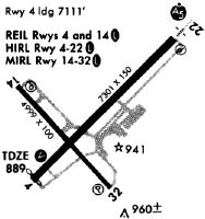
Runways
Runway Summary
| Runways: | 04/22 14/32 |
| Longest Runway: | 04/22 is 8101 ft (2469 m) long |
| Runways with an Instrument Approach: | 22 |
EAU Airport Runway Details
| Runway 04/22 | 8101 ft x 150 ft (2469 m x 46 m) | |
| Runway Length Source: | 3RD PARTY SURVEY as of 07/21/2016 | |
| Surface: | Concrete - Good condition - Saw-cut or plastic grooved | |
| Runway Pavement Class: | 54 /R/B/W/T | |
| Runway Edge Lights: | High Intensity | |
Runway Weight Bearing Capacity (in thousands of pounds) |
||
| Single Wheel Landing Gear: | 100.0 | |
| Dual Wheel Landing Gear: | 180.0 | |
| Dual Tandem Wheel Landing Gear: | 320.0 | |
Runway 04 |
Runway 22 |
|
Elevation: |
886.6 | 913.1 |
Latitude: |
44-51-33.4313N | 44-52-30.0140N |
Longitude: |
091-29-33.7776W | 091-28-14.2843W |
|
Runway True Alignment: |
045 | 225 |
ILS Type: |
ILS/DME | |
Glide Path Angle: |
3.0 degrees | 3.0 degrees |
Traffic Pattern: |
Left | Left |
Runway Markings Type: |
Precision Instrument | Precision Instrument |
Runway Markings Condition: |
Good | Good |
Object at End: |
ROAD | |
Object Height: |
4 | |
Distance from End: |
140 | |
Object Centerline Offset: |
481 ft. left of centerline | |
Visual Glide Slope Indicators: |
4-Light PAPI On Left Side Of Runway | 4-Light PAPI On Left Side Of Runway |
Approach Light System: |
1,400 Foot Medium Intensity Approach Lighting System With Runway Alignment Indicator Lights | |
REIL: |
Yes | No |
Touchdown Lights: |
No | No |
Centerline Lights: |
No | No |
Threshold Crossing Height: |
44 | 50 |
Threshold Elevation: |
886.4 | |
Displaced Threshold: |
400 | |
Threshold Latitude: |
44-51-36.2258N | |
Threshold Longitude: |
091-29-29.8530W | |
Declared Distances |
||
Take Off Run Avbl. (TORA): |
8101 | 8101 |
Take Off Distance Avbl. (TODA): |
8101 | 8101 |
Actual Stop Dist. Avbl. (ASDA): |
8101 | 7301 |
Landing Dist. Avbl. (LDA): |
7701 | 7301 |
| Runway 14/32 | 5000 ft x 100 ft (1524 m x 30 m) | |
| Runway Length Source: | 3RD PARTY SURVEY as of 07/21/2016 | |
| Surface: | Concrete - Good condition - No special surface treatment | |
| Runway Pavement Class: | 21 /R/B/W/T | |
| Runway Edge Lights: | Medium Intensity | |
Runway Weight Bearing Capacity (in thousands of pounds) |
||
| Single Wheel Landing Gear: | 40.0 | |
| Dual Wheel Landing Gear: | 60.0 | |
Runway 14 |
Runway 32 |
|
Elevation: |
882.8 | 887.6 |
Latitude: |
44-52-07.6876N | 44-51-30.4505N |
Longitude: |
091-29-41.1515W | 091-28-55.5739W |
|
Runway True Alignment: |
139 | 319 |
Glide Path Angle: |
3.0 degrees | 4.0 degrees |
Traffic Pattern: |
Left | Left |
Runway Markings Type: |
Nonprecision Instrument | Nonprecision Instrument |
Runway Markings Condition: |
Good | Good |
Object Centerline Offset: |
481 ft. left of centerline | |
Visual Glide Slope Indicators: |
4-Light PAPI On Left Side Of Runway | 4-Light PAPI On Left Side Of Runway |
REIL: |
Yes | |
Touchdown Lights: |
No | No |
Centerline Lights: |
No | No |
Threshold Crossing Height: |
43 | 70 |
Declared Distances |
||
Take Off Run Avbl. (TORA): |
5000 | 5000 |
Take Off Distance Avbl. (TODA): |
5000 | 5000 |
Actual Stop Dist. Avbl. (ASDA): |
5000 | 5000 |
Landing Dist. Avbl. (LDA): |
5000 | 5000 |
Services
Airframe Repair: |
Major |
Powerplant Repair: |
None |
Bottled Oxygen: |
None |
Bulk Oxygen: |
None |
Fuel Available: |
100LL, Jet A+, UL91 |
Landing Fees: |
No |
Parking: |
Tiedowns available |
Maps & Diagrams
EAU Sectional
Flight Planning
at skyvector.com
at skyvector.com