
Location
Latitude: |
51-17-22.2036N (51.289501) |
Longitude: |
006-46-00.408E (6.76678) |
Elevation: |
147 feet MSL (45 m MSL) |
Magnetic Variation: |
3 E (as of April 2024 from WMM2020 model) |
Time Zone: |
UTC +1.0 (Standard Time) UTC +2.0 (Daylight Savings Time) |
Contacts
Manager: |
: |
Operations
Airport Status: |
Operational |
Facility Use: |
Public |
Type: |
Airport |
Traffic Pattern Altitude (MSL): |
1147 feet (350 m) |
Based Aircraft
Annual Operations (as of )
Communications
| LANGEN INFO: | 129.875 |
| TWR: | 118.3 |
| CLNC DEL: | 121.775 |
| GND: | 121.9 |
| LANGEN RADAR: | 128.55 |
| ATIS: | 123.78 |
| DIR: | 128.65 |
| DE ICING: | 135.225 |
Fixed Based Operators (FBOs) & Fuel
(Click on a business for detail)
Please help us keep this information up to date. This is a FREE SERVICE just like everything else on Airport Guide! If you see that a business needs to be added, modified, or deleted please fill out our Update Form.
To add, modify, or delete a business click here.
Please help us keep this information up to date. This is a FREE SERVICE just like everything else on Airport Guide! If you see that a business needs to be added, modified, or deleted please fill out our Update Form.
| Business Name | Frequency | Phone | Fuel Grade |
|---|
Flight Service Stations
| Primary | Alternate | |
| FSS on Field: | ||
| FSS Name (ID): | ||
| Frequency: | ||
| Toll Free Phone: |
Instrument Procedures / Charts
Terminal Procedures are only available for airports in several countries with more being added all the time. If you are looking for a specific country's charts, please send an email to support(at)airportguide.com stating the country name. This will be used to prioritize the implementation.
Navigation Aids (Navaids) near DUS
| Dist (NM) | ID | Morse Code | Name | Type | Freq | True Hdg | Mag Hdg |
|---|---|---|---|---|---|---|---|
| 0.6 | DUS | Dusseldorf | VOR-DME | 115.15 | 232 | 229 | |
| 5.8 | LI | Dusseldorf | NDB | 417 | 53 | 50 | |
| 10.5 | MGB | Monchengladbach | NDB | 377 | 249 | 246 | |
| 10.8 | MHD | Monchengladbach | DME | 112.50 | 252 | 249 | |
| 10.8 | MHV | Monchengladbach | VOR | 109.80 | 253 | 250 | |
| 14.8 | LMA | Lima | NDB | 311 | 289 | 286 | |
| 15.6 | BAM | Barmen | VORTAC | 113.60 | 81 | 78 | |
| 20.2 | BOT | Bottrop | NDB | 407 | 28 | 25 | |
| 24.1 | WYP | Wipper | VOR | 109.60 | 126 | 123 | |
| 24.4 | LJ | Koln/Bonn | NDB | 365 | 152 | 149 | |
| 29.4 | KBO | Koln/Bonn | VOR-DME | 112.15 | 150 | 147 | |
| 29.8 | LW | Koln/Bonn | NDB | 301 | 141 | 138 | |
| 29.9 | NID | Niederrhein | DME | 115.50 | 308 | 305 | |
| 33.5 | GIX | Geilenkirchen | TACAN | 108.10 | 234 | 231 | |
| 34.2 | LV | Koln/Bonn | NDB | 327 | 148 | 145 | |
| 35.3 | DOR | Wickede | VOR-DME | 108.65 | 66 | 63 | |
| 35.4 | DWI | Dortmund | NDB | 357 | 66 | 63 | |
| 35.6 | THN | Thorn | NDB | 434 | 260 | 257 | |
| 35.8 | MAS | Maastricht | VOR-DME | 108.60 | 238 | 235 | |
| 37.2 | NW | Maastricht | NDB | 373 | 244 | 241 |
Nearby Airports with Fuel
| Dist (NM) | Name (Airport IDs) | True Hdg | Mag Hdg | Fuel Grade |
|---|---|---|---|---|
| 95.6 | Rotterdam Airport (RTM EHRD) |
295 | 293 | 100LL |
Notices to Airmen (NOTAMS)
Remarks
No remarks for this landing facility
Runways
Runway Summary
| Runways: | 05L/23R 05R/23L |
| Longest Runway: | 05R/23L is 9842 ft (3000 m) long |
| Runways with an Instrument Approach: |
DUS Airport Runway Details
| Runway 05L/23R | 8858 ft x 148 ft (2700 m x 45 m) | |
| Runway Edge Lights: | Yes Intensity | |
Runway 05L |
Runway 23R |
|
Elevation: |
116 | 124 |
Latitude: |
51.28369903564 | 51.29840087890 |
Longitude: |
6.7487201690673 | 6.7796502113342 |
|
Runway True Alignment: |
53 | 233 |
Glide Path Angle: |
0.0 degrees | 0.0 degrees |
REIL: |
Yes | Yes |
Threshold Elevation: |
116 | 124 |
Displaced Threshold: |
984 | 984 |
| Runway 05R/23L | 9842 ft x 148 ft (3000 m x 45 m) | |
| Runway Edge Lights: | Yes Intensity | |
Runway 05R |
Runway 23L |
|
Elevation: |
121 | 138 |
Latitude: |
51.27959823608 | 51.2958984375 |
Longitude: |
6.7519898414611 | 6.7862200736999 |
|
Runway True Alignment: |
53 | 233 |
Glide Path Angle: |
0.0 degrees | 0.0 degrees |
REIL: |
Yes | Yes |
Threshold Elevation: |
121 | 138 |
Displaced Threshold: |
984 | 984 |
Services
Fuel Available: |
100LL |
Maps & Diagrams
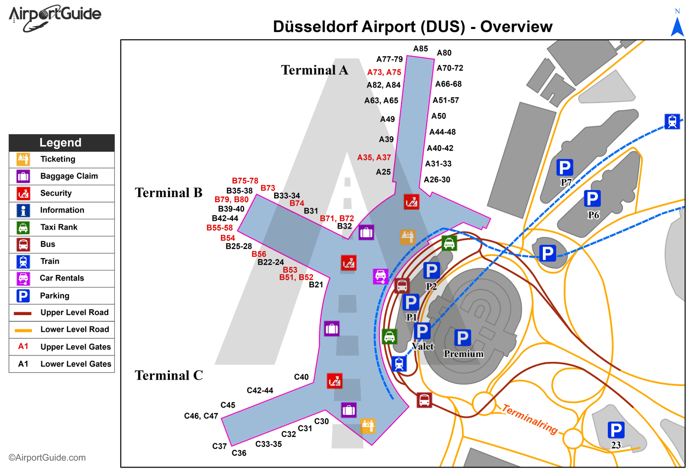
DUS Sectional
Flight Planning
at skyvector.com
at skyvector.com
