Location
Latitude: |
45-37-09.6786N (45.619355) |
Longitude: |
121-10-05.7926W (-121.168276) |
Elevation: |
246.5 feet MSL (75 m MSL) |
Magnetic Variation: |
14.5 E (as of April 2024 from WMM2020 model) |
Time Zone: |
UTC -8.0 (Standard Time) UTC -7.0 (Daylight Savings Time) |
From City: |
02 N.M. NE of The Dalles, Oregon |
Found On: |
Seattle Chart |
FAA Region: |
ANM |
Contacts
Manager: |
Publicly owned: |
| JEFF RENARD PO BOX 285 DALLES PORT, WA 98617 509-767-2272 |
CITY OF THE DALLES/KLICKITAT COUNTY PO BOX 285 DALLES PORT, WA 98617 509-767-2272 |
Operations
Airport Status: |
Operational |
Facility Use: |
Public |
Type: |
Airport |
Activation Date: |
06/1943 |
Control tower: |
No |
Attendance (Months/Days/Hours): |
Months/Days/Hours ALL/ALL/0800-1700 |
Boundary ARTCC: |
ZSE (Seattle) |
Responsible ARTCC: |
ZSE (Seattle) |
Lighting Schedule: |
SEE RMK |
Segmented Circle Indicator: |
Yes |
Traffic Pattern Altitude (MSL): |
1246 feet (380 m) |
NOTAMs Facility: |
DLS |
NOTAM-D Service: |
Yes |
International Airport of Entry: |
No |
Customs Landing Rights: |
No |
Military Landing Rights: |
Yes |
Civil/Military Joint Use: |
No |
Based Aircraft
| Single Engine: | 62 |
| Multi Engine: | 2 |
| GA Helicopters: | 2 |
| Gliders: | 1 |
Annual Operations (as of 01/28/2019)
| Total Operations: | 16282 | |
| Air Taxi: | 1852 | 11.4% |
| GA Local: | 4710 | 28.9% |
| GA Itinerant: | 8920 | 54.8% |
| Military Aircraft: | 800 | 4.9% |
Communications
| CTAF: | 123.000 |
| Unicom: | 123.000 |
| ASOS: | 135.175 (509-767-1726) |
- APCH/DEP CTL SVC PRVDD SEATTLE ARTCC (ZSE) ON FREQS 119.65/257.6 (KLICKITAT RCAG).
Fixed Based Operators (FBOs) & Fuel
(Click on a business for detail)
Please help us keep this information up to date. This is a FREE SERVICE just like everything else on Airport Guide! If you see that a business needs to be added, modified, or deleted please fill out our Update Form.
To add, modify, or delete a business click here.
Please help us keep this information up to date. This is a FREE SERVICE just like everything else on Airport Guide! If you see that a business needs to be added, modified, or deleted please fill out our Update Form.
Area Code: 541 |
| Business Name | Frequency | Phone | Fuel Grade |
|---|---|---|---|
| Flightline Services
Update FBO info |
767-1134 | 100ll Jet A | |
| Hall & Son Aircraft
Update FBO info |
767-1700 |
Flight Service Stations
| Primary | Alternate | |
| FSS on Field: | N | |
| FSS Name (ID): | Seattle(SEA) | |
| Frequency: | ||
| Toll Free Phone: | 1-800-WX-BRIEF |
Instrument Procedures / Charts
FAA Terminal Procedures valid from 0901Z 03/21/24 to 0901Z 04/18/24.
There are various types of charts available for an airport. They are listed in the Page Type column. Here is a legend for those types:
APD - Airport Diagram
DP - Departure Procedure Charts
HOT - Hot Spots
IAP - Instrument Approach Procedure Charts
MIN - Minimums
STAR - Standard Terminal Arrival Charts
| Page Type | Page Name | Volume | Action Since Last Cycle |
|---|---|---|---|
| IAP | COPTER LDA/DME RWY 25 | NW-1 | |
| IAP | LDA/DME RWY 25 | NW-1 | |
| IAP | RNAV (GPS)-A | NW-1 | |
| MIN | ALTERNATE MINIMUMS | NW-1 | |
| MIN | TAKEOFF MINIMUMS | NW-1 | |
| ODP | DALLES ONE (OBSTACLE) | NW-1 |
Terminal Procedures are only available for airports in several countries with more being added all the time. If you are looking for a specific country's charts, please send an email to support(at)airportguide.com stating the country name. This will be used to prioritize the implementation.
Navigation Aids (Navaids) near DLS
| Dist (NM) | ID | Morse Code | Name | Type | Freq | True Hdg | Mag Hdg |
|---|---|---|---|---|---|---|---|
| 6.3 | LTJ | . _ . . _ . _ _ _ | Klickitat | VOR-DME | 112.30 | 26 | 11 |
| 54.5 | LBH | . _ . . _ . . . . . . . | Laker | NDB | 332 | 265 | 250 |
| 60.2 | BTG | _ . . . _ _ _ . | Battle Ground | VORTAC | 116.60 | 277 | 262 |
| 60.3 | PDX | . _ _ . _ . . _ . . _ | Portland | VOT | 111.00 | 269 | 254 |
| 60.4 | PDX | . _ _ . _ . . _ . . _ | Portland | VOR-DME | 111.80 | 269 | 254 |
| 60.6 | CBU | _ . _ . _ . . . . . _ | Columbia | TACAN | 109.20 | 268 | 253 |
| 63.7 | YK | _ . _ _ _ . _ | Donny | NDB | 371 | 31 | 16 |
| 64.5 | YKM | _ . _ _ _ . _ _ _ | Yakima | VORTAC | 116.00 | 27 | 12 |
| 74.9 | HIO | . . . . . . _ _ _ | Hillsboro | VOT | 115.20 | 267 | 252 |
| 77.8 | UBG | . . _ _ . . . _ _ . | Newberg | VOR-DME | 117.40 | 258 | 243 |
| 78.8 | PND | . _ _ . _ . _ . . | Banks | NDB | 356 | 271 | 256 |
| 78.9 | RD | . _ . _ . . | Bodey | NDB | 411 | 175 | 161 |
| 79.6 | LSO | . _ . . . . . _ _ _ | Kelso | NDB | 256 | 294 | 279 |
| 82.2 | DSD | _ . . . . . _ . . | Deschutes | VORTAC | 117.60 | 184 | 170 |
| 84.8 | IMB | . . _ _ _ . . . | Kimberly | VOR-DME | 115.60 | 132 | 118 |
| 88.4 | SL | . . . . _ . . | Turno | NDB | 266 | 239 | 224 |
| 89.3 | ELN | . . _ . . _ . | Ellensburg | VOR-DME | 117.90 | 18 | 3 |
| 93.6 | PDT | . _ _ . _ . . _ | Pendleton | VORTAC | 114.70 | 86 | 72 |
| 94.1 | PSC | . _ _ . . . . _ . _ . | Pasco | VOR-DME | 113.75 | 64 | 50 |
Nearby Airports with Fuel
Notices to Airmen (NOTAMS)
Remarks
| A110-1 | MTNS BYD 5000' APCH RY 31. |
| A110-2 | ALL TWYS MARKED WITH REFLECTORS. |
| A110-3 | WATERFOWL ON AND INVOF ARPT. |
| A110-4 | PRIOR PERMISSION REQUIRED FOR OVERWEIGHT LNDGS. |
| A110-5 | FOR CD CTC SEATTLE ARTCC AT 253-351-3694. |
| A16 | ADNL CTC - 541-288-6766. MANAGER@FLYCGRA.COM. |
| A57-07 | RWY 07 , SLP 39:1 TO DTHR. |
| A57-13 | RWY 13 APCH SLP 19:1 TO DTHR. |
| A57-25 | THLD DSPLCD TO PROVIDE SAFETY AREA. |
| A58-07 | RWY 07 +15 FTROAD, 0 FT FM END, 200 FT R. |
| A81-APT | ACTVT MIRL RYS 13/31 & 07/25, & REIL RY 31 - CTAF. REIL OPERATES ON 7 CLICKS ONLY. |
| E111 | ESTABD PRIOR TO 1959. |
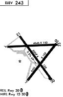
Runways
Runway Summary
| Runways: | 07/25 13/31 |
| Longest Runway: | 13/31 is 5097 ft (1554 m) long |
| Runways with an Instrument Approach: | 25 |
DLS Airport Runway Details
| Runway 07/25 | 4647 ft x 100 ft (1416 m x 30 m) | |
| Surface: | Asphalt - Good condition - No special surface treatment | |
| Runway Edge Lights: | Medium Intensity | |
Runway Weight Bearing Capacity (in thousands of pounds) |
||
| Single Wheel Landing Gear: | 30.0 | |
| Dual Wheel Landing Gear: | 30.0 | |
Runway 07 |
Runway 25 |
|
Elevation: |
211.1 | 242.7 |
Latitude: |
45-37-14.8940N | 45-37-16.4880N |
Longitude: |
121-10-40.8650W | 121-09-35.5300W |
|
Runway True Alignment: |
088 | 268 |
ILS Type: |
LDA/DME | |
Glide Path Angle: |
0.0 degrees | 0.0 degrees |
Traffic Pattern: |
Left | Left |
Runway Markings Type: |
Precision Instrument | Precision Instrument |
Runway Markings Condition: |
Fair | Fair |
Object at End: |
TREES | |
Object Height: |
24 | |
Distance from End: |
516 | |
Object Centerline Offset: |
0 ft. left and right of centerline | |
Threshold Elevation: |
212.3 | 242.9 |
Displaced Threshold: |
440 | 196 |
Threshold Latitude: |
45-37-15.0450N | 45-37-16.4210N |
Threshold Longitude: |
121-10-34.6760W | 121-09-38.2830W |
| Runway 13/31 | 5097 ft x 100 ft (1554 m x 30 m) | |
| Surface: | Asphalt - Good condition - No special surface treatment | |
| Runway Pavement Class: | 32 /F/C/X/T | |
| Runway Edge Lights: | Medium Intensity | |
Runway Weight Bearing Capacity (in thousands of pounds) |
||
| Single Wheel Landing Gear: | 30.0 | |
| Dual Wheel Landing Gear: | 30.0 | |
Runway 13 |
Runway 31 |
|
Elevation: |
210.9 | 238.9 |
Latitude: |
45-37-24.7080N | 45-36-43.6840N |
Longitude: |
121-10-24.3630W | 121-09-42.8410W |
|
Runway True Alignment: |
145 | 325 |
Glide Path Angle: |
0.0 degrees | 0.0 degrees |
Traffic Pattern: |
Left | Left |
Runway Markings Type: |
Basic | Basic |
Runway Markings Condition: |
Good | Good |
Object at End: |
TREES | |
Object Height: |
100 | |
Distance from End: |
1733 | |
Object Centerline Offset: |
0 ft. left and right of centerline | |
REIL: |
Yes | |
Threshold Elevation: |
210.9 | |
Displaced Threshold: |
200 | |
Threshold Latitude: |
45-37-23.0930N | |
Threshold Longitude: |
121-10-22.7470W |
Services
Airframe Repair: |
Major |
Powerplant Repair: |
Major |
Bottled Oxygen: |
None |
Bulk Oxygen: |
None |
Fuel Available: |
100LL, Jet A |
Landing Fees: |
No |
Parking: |
Tiedowns available |
Maps & Diagrams
DLS Sectional
Flight Planning
at skyvector.com
at skyvector.com