Location
Latitude: |
34-40-20.0000N (34.672222) |
Longitude: |
082-53-09.2000W (-82.885889) |
Elevation: |
890.6 feet MSL (271 m MSL) |
Magnetic Variation: |
6.6 W (as of April 2024 from WMM2020 model) |
Time Zone: |
UTC -5.0 (Standard Time) UTC -4.0 (Daylight Savings Time) |
From City: |
03 N.M. W of Clemson, South Carolina |
Found On: |
Atlanta Chart |
FAA Region: |
ASO |
Contacts
Manager: |
Publicly owned: |
| JEFF GARRISON 365 AIRPORT RD SENECA, SC 29678 864-882-2959 |
OCONEE COUNTY COUNTY MAIL ROOM WALHALLA, SC 29691 864-638-4242 |
Operations
Airport Status: |
Operational |
Facility Use: |
Public |
Type: |
Airport |
Control tower: |
No |
Attendance (Months/Days/Hours): |
Months/Days/Hours ALL/MON-SAT/0800-1800 |
Boundary ARTCC: |
ZTL (Atlanta) |
Responsible ARTCC: |
ZTL (Atlanta) |
Lighting Schedule: |
SEE RMK |
Segmented Circle Indicator: |
Yes |
Traffic Pattern Altitude (MSL): |
1891 feet (576 m) |
NOTAMs Facility: |
CEU |
NOTAM-D Service: |
Yes |
International Airport of Entry: |
No |
Customs Landing Rights: |
No |
Military Landing Rights: |
Yes |
Civil/Military Joint Use: |
No |
Based Aircraft
| Single Engine: | 52 |
| Multi Engine: | 3 |
| Jet Engine: | 1 |
| GA Helicopters: | 2 |
Annual Operations (as of 03/16/2023)
| Total Operations: | 21150 | |
| Air Taxi: | 1465 | 6.9% |
| GA Local: | 14651 | 69.3% |
| GA Itinerant: | 4884 | 23.1% |
| Military Aircraft: | 150 | 0.7% |
Communications
| CTAF: | 122.700 |
| Unicom: | 122.700 |
| Approach: | GREER 118.8 118.8 ATLANTA ARTCC |
| Departure: | GREER 118.8 118.8 ATLANTA ARTCC |
| ASOS: | 119.275 (864-653-8855) |
- APCH/DEP SVC PRVDD BY ATLANTA ARTCC ON FREQS 134.8/379.95 (MOUNT OGLETHORPE RCAG) WHEN APCH CTL CLSD.
Fixed Based Operators (FBOs) & Fuel
(Click on a business for detail)
Please help us keep this information up to date. This is a FREE SERVICE just like everything else on Airport Guide! If you see that a business needs to be added, modified, or deleted please fill out our Update Form.
To add, modify, or delete a business click here.
Please help us keep this information up to date. This is a FREE SERVICE just like everything else on Airport Guide! If you see that a business needs to be added, modified, or deleted please fill out our Update Form.
Area Code: 864 |
| Business Name | Frequency | Phone | Fuel Grade |
|---|---|---|---|
| Clemson Oconee County Airport
Update FBO info |
Unicom 122.7 | 882-2959 | 100LL, Jet A |
| Lakeside Aircraft Service
Update FBO info |
Unicom 122.7 | 888-2311 |
Flight Service Stations
| Primary | Alternate | |
| FSS on Field: | N | |
| FSS Name (ID): | Anderson(AND) | |
| Frequency: | ||
| Toll Free Phone: | 1-800-WX-BRIEF |
Instrument Procedures / Charts
FAA Terminal Procedures valid from 0901Z 03/21/24 to 0901Z 04/18/24.
There are various types of charts available for an airport. They are listed in the Page Type column. Here is a legend for those types:
APD - Airport Diagram
DP - Departure Procedure Charts
HOT - Hot Spots
IAP - Instrument Approach Procedure Charts
MIN - Minimums
STAR - Standard Terminal Arrival Charts
| Page Type | Page Name | Volume | Action Since Last Cycle |
|---|---|---|---|
| IAP | RNAV (GPS) RWY 07 | SE-2 | |
| IAP | RNAV (GPS) RWY 25 | SE-2 | |
| MIN | ALTERNATE MINIMUMS | SE-2 | |
| MIN | TAKEOFF MINIMUMS | SE-2 |
Terminal Procedures are only available for airports in several countries with more being added all the time. If you are looking for a specific country's charts, please send an email to support(at)airportguide.com stating the country name. This will be used to prioritize the implementation.
Navigation Aids (Navaids) near CEU
| Dist (NM) | ID | Morse Code | Name | Type | Freq | True Hdg | Mag Hdg |
|---|---|---|---|---|---|---|---|
| 0.1 | CEU | _ . _ . . . . _ | Clemson | NDB | 257 | 334 | 341 |
| 12.3 | LQK | . _ . . _ _ . _ _ . _ | Lake Keowee | NDB | 408 | 47 | 54 |
| 16.0 | ELW | . . _ . . . _ _ | Electric City | VORTAC | 108.60 | 161 | 168 |
| 20.4 | ODF | _ _ _ _ . . . . _ . | Foothills | VOR-DME | 113.40 | 274 | 280 |
| 21.9 | GY | _ _ . _ . _ _ | Dyana | NDB | 338 | 86 | 93 |
| 27.2 | GM | _ _ . _ _ | Judky | NDB | 521 | 76 | 83 |
| 34.4 | AJR | . _ . _ _ _ . _ . | Habersham | NDB | 347 | 252 | 258 |
| 41.4 | BRA | _ . . . . _ . . _ | Broad River | NDB | 379 | 29 | 36 |
| 44.1 | GRD | _ _ . . _ . _ . . | Greenwood | TACAN | 115.50 | 124 | 131 |
| 46.3 | BJT | _ . . . . _ _ _ _ | Bulldog | NDB | 221 | 201 | 207 |
| 46.5 | FRT | . . _ . . _ . _ | Fairmont | NDB | 248 | 72 | 79 |
| 46.8 | GIW | _ _ . . . . _ _ | Coronaca | NDB | 239 | 122 | 129 |
| 48.3 | DDA | _ . . _ . . . _ | Commerce | NDB | 244 | 220 | 226 |
| 48.6 | AHN | . _ . . . . _ . | Athens | VOR-DME | 116.95 | 206 | 212 |
| 52.0 | SPA | . . . . _ _ . . _ | Spartanburg | VORTAC | 115.70 | 65 | 72 |
| 53.3 | HRS | . . . . . _ . . . . | Harris | VORTAC | 109.80 | 288 | 294 |
| 53.5 | SUG | . . . . . _ _ _ . | Sugarloaf Mountain | VORTAC | 112.20 | 34 | 41 |
| 53.7 | IM | . . _ _ | Keans | NDB | 357 | 15 | 22 |
| 54.0 | IIY | . . . . _ . _ _ | Washington/Wilkes County | NDB | 435 | 176 | 183 |
| 56.3 | BMW | _ . . . _ _ . _ _ | Barrow County | NDB | 404 | 218 | 224 |
Nearby Airports with Fuel
Notices to Airmen (NOTAMS)
Remarks
| A110-1 | NO LINE-OF-SIGHT BETWEEN RWY ENDS. |
| A110-5 | ACFT MAY BE OPERATING FROM PVT ARPT 1 NM WEST-NORTHWEST OF ARPT. |
| A110-7 | RY 7/25 PAEW ADJ 1200-2100 DLY. |
| A110-8 | FOR CD CTC GREER APCH AT 864-877-8275. WHEN GREER APCH CLSD, FOR CD CTC ATLANTA ARTCC AT 770-210-7692. |
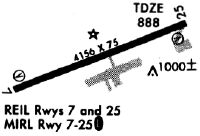
| A81-APT | ACTVT REIL RWY 07 & 25; PAPI RWY 07 & 25; MIRL RWY 07/25 - CTAF. |
Runways
Runway Summary
| Runways: | 07/25 |
| Longest Runway: | 07/25 is 5000 ft (1524 m) long |
| Runways with an Instrument Approach: |
CEU Airport Runway Details
| Runway 07/25 | 5000 ft x 100 ft (1524 m x 30 m) | |
| Runway Length Source: | 3RD PARTY SURVEY as of 06/09/2009 | |
| Surface: | Asphalt - Good condition - No special surface treatment | |
| Runway Pavement Class: | 10 /F/C/Y/T | |
| Runway Edge Lights: | Medium Intensity | |
Runway Weight Bearing Capacity (in thousands of pounds) |
||
| Single Wheel Landing Gear: | 28.5 | |
| Dual Wheel Landing Gear: | 44.0 | |
Runway 07 |
Runway 25 |
|
Elevation: |
888.1 | 874.4 |
Latitude: |
34-40-10.6608N | 34-40-29.3722N |
Longitude: |
082-53-36.9339W | 082-52-41.5213W |
|
Runway True Alignment: |
068 | 248 |
Glide Path Angle: |
3.0 degrees | 3.0 degrees |
Traffic Pattern: |
Right | Left |
Runway Markings Type: |
Nonprecision Instrument | Nonprecision Instrument |
Runway Markings Condition: |
Good | Good |
Object at End: |
TREE | TREE |
Object Height: |
95 | 30 |
Distance from End: |
1756 | 829 |
Object Centerline Offset: |
652 ft. right of centerline | 423 ft. right of centerline |
Visual Glide Slope Indicators: |
2-Light PAPI On Left Side Of Runway | 2-Light PAPI On Left Side Of Runway |
REIL: |
Yes | Yes |
Threshold Crossing Height: |
39 | 33 |
Services
Airframe Repair: |
Major |
Powerplant Repair: |
Major |
Bottled Oxygen: |
None |
Bulk Oxygen: |
None |
Fuel Available: |
100LL, Jet A+ |
Landing Fees: |
No |
Parking: |
Tiedowns available |
Maps & Diagrams
CEU Sectional
Flight Planning
at skyvector.com
at skyvector.com