Location
Latitude: |
41-25-29.1000N (41.42475) |
Longitude: |
088-25-07.2000W (-88.418667) |
Elevation: |
584.7 feet MSL (178 m MSL) |
Magnetic Variation: |
3.5 W (as of April 2024 from WMM2020 model) |
Time Zone: |
UTC -6.0 (Standard Time) UTC -5.0 (Daylight Savings Time) |
From City: |
04 N.M. N of Morris, Illinois |
Found On: |
Chicago Chart |
FAA Region: |
AGL |
Contacts
Manager: |
Publicly owned: |
| JEFF VOGEN 9980 NO. HIGHWAY 47 MORRIS, IL 60450 815-942-1600 |
CITY OF MORRIS 700 N. DIVISION ST MORRIS, IL 60450 815-942-5438 |
Operations
Airport Status: |
Operational |
Facility Use: |
Public |
Type: |
Airport |
Activation Date: |
12/1944 |
Control tower: |
No |
Attendance (Months/Days/Hours): |
Months/Days/Hours ALL/ALL/0600-1800 |
Boundary ARTCC: |
ZAU (Chicago) |
Responsible ARTCC: |
ZAU (Chicago) |
Lighting Schedule: |
SEE RMK |
Segmented Circle Indicator: |
Yes |
Traffic Pattern Altitude (MSL): |
1585 feet (483 m) |
NOTAMs Facility: |
C09 |
NOTAM-D Service: |
Yes |
International Airport of Entry: |
No |
Customs Landing Rights: |
No |
Military Landing Rights: |
Yes |
Civil/Military Joint Use: |
No |
Based Aircraft
| Single Engine: | 58 |
| Multi Engine: | 3 |
| Jet Engine: | 1 |
Annual Operations (as of 07/31/2023)
| Total Operations: | 42300 | |
| Air Taxi: | 1000 | 2.4% |
| GA Local: | 19000 | 44.9% |
| GA Itinerant: | 22000 | 52.0% |
| Military Aircraft: | 300 | 0.7% |
Communications
| CTAF: | 122.800 |
| Unicom: | 122.800 |
| Approach: | CHICAGO 119.35 119.35 |
| Departure: | CHICAGO 119.35 119.35 |
| AWOS-3: | 118.175 (815-941-1815) |
Fixed Based Operators (FBOs) & Fuel
(Click on a business for detail)
Please help us keep this information up to date. This is a FREE SERVICE just like everything else on Airport Guide! If you see that a business needs to be added, modified, or deleted please fill out our Update Form.
To add, modify, or delete a business click here.
Please help us keep this information up to date. This is a FREE SERVICE just like everything else on Airport Guide! If you see that a business needs to be added, modified, or deleted please fill out our Update Form.
Area Code: 815 |
| Business Name | Frequency | Phone | Fuel Grade |
|---|---|---|---|
| The Littlefield Aeroplane Co.
Update FBO info |
122.8 | 941-0063 | 80, 100LL |
Flight Service Stations
| Primary | Alternate | |
| FSS on Field: | N | |
| FSS Name (ID): | Kankakee(IKK) | |
| Frequency: | ||
| Toll Free Phone: | 1-800-WX-BRIEF |
Instrument Procedures / Charts
FAA Terminal Procedures valid from 0901Z 03/21/24 to 0901Z 04/18/24.
There are various types of charts available for an airport. They are listed in the Page Type column. Here is a legend for those types:
APD - Airport Diagram
DP - Departure Procedure Charts
HOT - Hot Spots
IAP - Instrument Approach Procedure Charts
MIN - Minimums
STAR - Standard Terminal Arrival Charts
| Page Type | Page Name | Volume | Action Since Last Cycle |
|---|---|---|---|
| IAP | RNAV (GPS) RWY 18 | EC-3 | |
| IAP | RNAV (GPS) RWY 36 | EC-3 | |
| IAP | VOR-A | EC-3 | |
| MIN | ALTERNATE MINIMUMS | EC-3 | |
| MIN | TAKEOFF MINIMUMS | EC-3 |
Terminal Procedures are only available for airports in several countries with more being added all the time. If you are looking for a specific country's charts, please send an email to support(at)airportguide.com stating the country name. This will be used to prioritize the implementation.
Navigation Aids (Navaids) near C09
| Dist (NM) | ID | Morse Code | Name | Type | Freq | True Hdg | Mag Hdg |
|---|---|---|---|---|---|---|---|
| 8.6 | JOT | . _ _ _ _ _ _ _ | Joliet | VOR-DME | 112.30 | 31 | 35 |
| 20.0 | OIX | _ _ _ . . _ . . _ | Ottawa | NDB | 266 | 259 | 262 |
| 28.1 | DPA | _ . . . _ _ . . _ | Dupage | VOR-DME | 108.40 | 6 | 10 |
| 29.8 | EON | . _ _ _ _ . | Peotone | VORTAC | 113.20 | 108 | 112 |
| 31.5 | HK | . . . . _ . _ | Ermin | NDB | 332 | 55 | 59 |
| 33.2 | IKK | . . _ . _ _ . _ | Kankakee | DME | 111.6 | 129 | 133 |
| 33.7 | IK | . . _ . _ | Lukow | NDB | 272 | 136 | 140 |
| 36.9 | MDW | _ _ _ . . . _ _ | Chicago Midway | VOT | 111.00 | 53 | 57 |
| 37.0 | ME | _ _ . | Deana | NDB | 350 | 28 | 32 |
| 37.8 | MX | _ _ _ . . _ | Kedzi | NDB | 248 | 59 | 63 |
| 38.4 | CGT | _ . _ . _ _ . _ | Chicago Heights | VORTAC | 114.20 | 82 | 86 |
| 38.9 | PNT | . _ _ . _ . _ | Pontiac | VOR-DME | 109.60 | 201 | 204 |
| 40.9 | ORD | _ _ _ . _ . _ . . | Chicago O'hare | VOR-DME | 113.90 | 34 | 38 |
| 41.3 | GCO | _ _ . _ . _ . _ _ _ | Chicago | DME | 108.25 | 33 | 37 |
| 51.4 | RF | . _ . . . _ . | Gilmy | NDB | 275 | 323 | 326 |
| 51.9 | RBS | . _ . _ . . . . . . | Roberts | VOR-DME | 116.80 | 167 | 171 |
| 52.2 | OBK | _ _ _ _ . . . _ . _ | Northbrook | VOR-DME | 113.00 | 23 | 27 |
| 55.1 | BDF | _ . . . _ . . . . _ . | Bradford | VORTAC | 114.70 | 253 | 256 |
| 55.8 | LH | . _ . . . . . . | Egrow | NDB | 334 | 201 | 204 |
| 59.2 | PLL | . _ _ . . _ . . . _ . . | Polo | VOR-DME | 111.20 | 303 | 306 |
Nearby Airports with Fuel
Notices to Airmen (NOTAMS)
Remarks
| A110-1 | FOR CD CTC CHICAGO APCH AT 847-289-0926. |
| A15 | EMAIL ADDRESS: JVAZTEC@MSN.COM (ALL LOWER CASE) |
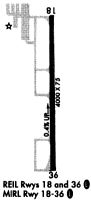
| A81-APT | RWY 18/36 MIRL AND RWY 18 & 36 REIL ON PHOTO CELL. MIRL RWY 18/36 PRESET ON LOW INTST; TO INCR INTST & ACTVT REIL RWY 18 & 36 - CTAF. |
| E111 | EXISTED PRIOR TO 1959. |
Runways
Runway Summary
| Runways: | 18/36 |
| Longest Runway: | 18/36 is 5501 ft (1677 m) long |
| Runways with an Instrument Approach: |
C09 Airport Runway Details
| Runway 18/36 | 5501 ft x 75 ft (1677 m x 23 m) | |
| Runway Length Source: | 3RD PARTY SURVEY as of 01/18/2017 | |
| Surface: | Asphalt - Good condition - No special surface treatment | |
| Runway Edge Lights: | Medium Intensity | |
Runway Weight Bearing Capacity (in thousands of pounds) |
||
| Single Wheel Landing Gear: | 4.0 | |
| Dual Wheel Landing Gear: | 125.0 | |
Runway 18 |
Runway 36 |
|
Elevation: |
584.1 | 564.6 |
Latitude: |
41-25-56.2543N | 41-25-01.9127N |
Longitude: |
088-25-07.8462W | 088-25-06.5656W |
|
Runway True Alignment: |
179 | 359 |
Glide Path Angle: |
3.0 degrees | 3.0 degrees |
Traffic Pattern: |
Left | Left |
Runway Markings Type: |
Nonprecision Instrument | Nonprecision Instrument |
Runway Markings Condition: |
Good | Good |
Visual Glide Slope Indicators: |
4-Light PAPI On Left Side Of Runway | 4-Light PAPI On Right Side Of Runway |
REIL: |
Yes | Yes |
Touchdown Lights: |
No | No |
Centerline Lights: |
No | No |
Threshold Crossing Height: |
44 | 43 |
Services
Airframe Repair: |
Major |
Powerplant Repair: |
Major |
Bottled Oxygen: |
High Pressure / Low Pressure |
Bulk Oxygen: |
High Pressure / Low Pressure |
Fuel Available: |
100LL, Jet A |
Landing Fees: |
No |
Parking: |
Hangars and tiedowns available |
Maps & Diagrams
C09 Sectional
Flight Planning
at skyvector.com
at skyvector.com