
Location
Latitude: |
59-21-15.8423N (59.354401) |
Longitude: |
017-56-30.1199E (17.9417) |
Elevation: |
47 feet MSL (14 m MSL) |
Magnetic Variation: |
7.4 E (as of April 2024 from WMM2020 model) |
Time Zone: |
UTC +1.0 (Standard Time) UTC +2.0 (Daylight Savings Time) |
Contacts
Manager: |
: |
Operations
Airport Status: |
Operational |
Facility Use: |
Public |
Type: |
Airport |
Traffic Pattern Altitude (MSL): |
1047 feet (319 m) |
Based Aircraft
Annual Operations (as of )
Communications
| CTAF: | 126.7 |
| CTAF: | 118.9 |
| CTAF: | 127.45 |
| CTAF: | 126.7 |
| CTAF: | 126.85 |
| CTAF: | 126 |
| CTAF: | 126.7 |
| CTAF: | 126.7 |
| CTAF: | 126.5 |
| CTAF: | 126.7 |
| TWR: | 118.1 |
| GND: | 121.6 |
| APP: | 120.15 |
| ATIS: | 122.45 |
| BRISBANE CNTR: | 118.2 |
| MELBOURNE CNTR: | 123.05 |
| BRISBANE CNTR: | 121.2 |
| AFIS: | 119.4 |
| BRISBANE CNTR: | 120.55 |
| BRISBANE CNTR: | 123.7 |
| MELBOURNE CNTR: | 123.9 |
| MELBOURNE CNTR: | 125.8 |
| MELBOURNE CNTR: | 122.1 |
| BRISBANE CNTR: | 123.95 |
| BRISBANE CNTR: | 120.3 |
Fixed Based Operators (FBOs) & Fuel
(Click on a business for detail)
Please help us keep this information up to date. This is a FREE SERVICE just like everything else on Airport Guide! If you see that a business needs to be added, modified, or deleted please fill out our Update Form.
To add, modify, or delete a business click here.
Please help us keep this information up to date. This is a FREE SERVICE just like everything else on Airport Guide! If you see that a business needs to be added, modified, or deleted please fill out our Update Form.
| Business Name | Frequency | Phone | Fuel Grade |
|---|
Flight Service Stations
| Primary | Alternate | |
| FSS on Field: | ||
| FSS Name (ID): | ||
| Frequency: | ||
| Toll Free Phone: |
Instrument Procedures / Charts
Terminal Procedures are only available for airports in several countries with more being added all the time. If you are looking for a specific country's charts, please send an email to support(at)airportguide.com stating the country name. This will be used to prioritize the implementation.
Navigation Aids (Navaids) near BMA
| Dist (NM) | ID | Morse Code | Name | Type | Freq | True Hdg | Mag Hdg |
|---|---|---|---|---|---|---|---|
| 3.9 | OU | Bromma | NDB | 322 | 125 | 118 | |
| 4.8 | NB | Bromma | NDB | 394 | 305 | 298 | |
| 8.1 | NAK | Nacka | NDB | 335 | 116 | 109 | |
| 11.1 | CG | Arlanda | NDB | 352 | 356 | 349 | |
| 13.3 | OHT | Arlanda | NDB | 370 | 353 | 346 | |
| 13.3 | TEB | Tebby | VOR-DME | 117.10 | 36 | 29 | |
| 14.5 | ASW | Arlanda | DME | 113.75 | 345 | 338 | |
| 15.1 | COR | Corner | NDB | 388 | 248 | 241 | |
| 18.0 | ARL | Arlanda | VOR-DME | 116.00 | 357 | 350 | |
| 20.7 | ANE | Arlanda | DME | 113.30 | 9 | 2 | |
| 21.0 | LNA | Lena | NDB | 330 | 302 | 295 | |
| 21.3 | DL | Arlanda | NDB | 360 | 3 | 356 | |
| 21.7 | ANW | Arlanda | DME | 112.05 | 352 | 345 | |
| 22.5 | LA | Arlanda | NDB | 404 | 0 | 353 | |
| 28.4 | TRS | Trosa | VOR-DME | 114.30 | 208 | 201 | |
| 29.8 | DKR | Dunker | VOR | 116.80 | 253 | 246 | |
| 34.5 | NTL | Nortel | VOR-DME | 116.30 | 46 | 38 | |
| 34.6 | ERK | Erken | NDB | 383 | 20 | 12 | |
| 38.3 | UP | Uppsala | NDB | 366 | 349 | 342 | |
| 41.7 | ARS | Aros | VOR-DME | 112.80 | 290 | 283 |
Nearby Airports with Fuel
| Dist (NM) | Name (Airport IDs) | True Hdg | Mag Hdg | Fuel Grade |
|---|
Notices to Airmen (NOTAMS)
Remarks
No remarks for this landing facility
Runways
Runway Summary
| Runways: | 12/30 |
| Longest Runway: | 12/30 is 5472 ft (1668 m) long |
| Runways with an Instrument Approach: |
BMA Airport Runway Details
| Runway 12/30 | 5472 ft x 148 ft (1668 m x 45 m) | |
| Runway Edge Lights: | Yes Intensity | |
Runway 12 |
Runway 30 |
|
Elevation: |
46 | 42 |
Latitude: |
59.35869979858 | 59.35010147094 |
Longitude: |
17.929599761962 | 17.953699111938 |
|
Runway True Alignment: |
125 | 305 |
Glide Path Angle: |
0.0 degrees | 0.0 degrees |
REIL: |
Yes | Yes |
Threshold Elevation: |
46 | 42 |
Services
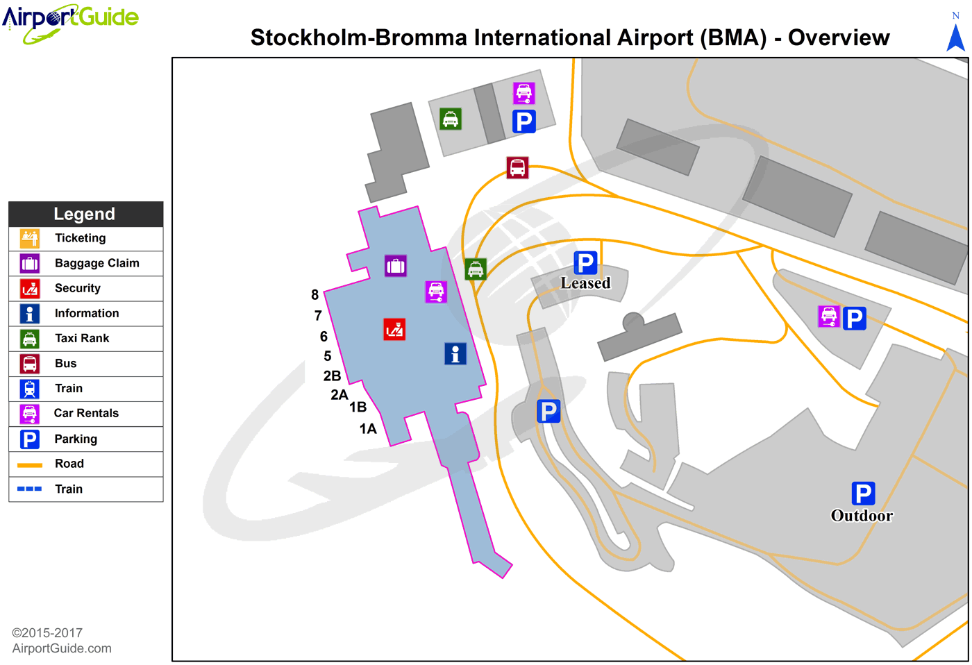
Maps & Diagrams
BMA Sectional
Flight Planning
at skyvector.com
at skyvector.com
