Location
Latitude: |
32-43-07.5220N (32.718756) |
Longitude: |
098-53-29.7470W (-98.891596) |
Elevation: |
1284.2 feet MSL (391 m MSL) |
Magnetic Variation: |
3.9 E (as of April 2024 from WMM2020 model) |
Time Zone: |
UTC -6.0 (Standard Time) UTC -5.0 (Daylight Savings Time) |
From City: |
02 N.M. S of Breckenridge, Texas |
Found On: |
Dallas-Ft Worth Chart |
FAA Region: |
ASW |
Contacts
Manager: |
Publicly owned: |
| MICHAEL ROACH STEPHENS COUNTY COURTHOUSE, 200 WEST WALKER BRECKENRIDGE, TX 76424 254-559-2190 |
STEPHENS COUNTY STEPHENS COUNTY COURTHOUSE, 200 WEST WALKER BRECKENRIDGE, TX 76424 254-559-2190 |
Operations
Airport Status: |
Operational |
Facility Use: |
Public |
Type: |
Airport |
Activation Date: |
10/1937 |
Control tower: |
No |
Attendance (Months/Days/Hours): |
Months/Days/Hours ALL/MON-FRI/0800-1700 |
Boundary ARTCC: |
ZFW (Fort Worth) |
Responsible ARTCC: |
ZFW (Fort Worth) |
Lighting Schedule: |
SEE RMK |
Segmented Circle Indicator: |
Yes |
Traffic Pattern Altitude (MSL): |
2284 feet (696 m) |
NOTAMs Facility: |
FTW |
NOTAM-D Service: |
Yes |
International Airport of Entry: |
No |
Customs Landing Rights: |
No |
Military Landing Rights: |
Yes |
Civil/Military Joint Use: |
No |
Based Aircraft
| Single Engine: | 11 |
| Multi Engine: | 3 |
Annual Operations (as of 11/13/2023)
| Total Operations: | 15200 | |
| GA Local: | 11400 | 75.0% |
| GA Itinerant: | 3800 | 25.0% |
Communications
| CTAF: | 122.800 |
| Unicom: | 122.800 |
| AWOS-3: | 120.175 (254-559-5525) |
- APCH/DEP CTL SVC PRVDD BY FORT WORTH ARTCC (ZFW) ON FREQS 127.0/360.6 (MINERAL WELLS RCAG).
Fixed Based Operators (FBOs) & Fuel
(Click on a business for detail)
Please help us keep this information up to date. This is a FREE SERVICE just like everything else on Airport Guide! If you see that a business needs to be added, modified, or deleted please fill out our Update Form.
To add, modify, or delete a business click here.
Please help us keep this information up to date. This is a FREE SERVICE just like everything else on Airport Guide! If you see that a business needs to be added, modified, or deleted please fill out our Update Form.
Area Code: 254 |
| Business Name | Frequency | Phone | Fuel Grade |
|---|---|---|---|
| Breck Airways
Update FBO info |
Unicom 122.8 | 559-9129 | 100LL, Jet A |
Flight Service Stations
| Primary | Alternate | |
| FSS on Field: | N | |
| FSS Name (ID): | Fort Worth(FTW) | |
| Frequency: | ||
| Toll Free Phone: | 1-800-WX-BRIEF |
Instrument Procedures / Charts
FAA Terminal Procedures valid from 0901Z 03/21/24 to 0901Z 04/18/24.
There are various types of charts available for an airport. They are listed in the Page Type column. Here is a legend for those types:
APD - Airport Diagram
DP - Departure Procedure Charts
HOT - Hot Spots
IAP - Instrument Approach Procedure Charts
MIN - Minimums
STAR - Standard Terminal Arrival Charts
| Page Type | Page Name | Volume | Action Since Last Cycle |
|---|---|---|---|
| IAP | RNAV (GPS) RWY 17 | SC-2 | |
| IAP | RNAV (GPS) RWY 35 | SC-2 | |
| MIN | ALTERNATE MINIMUMS | SC-2 | |
| MIN | TAKEOFF MINIMUMS | SC-2 |
Terminal Procedures are only available for airports in several countries with more being added all the time. If you are looking for a specific country's charts, please send an email to support(at)airportguide.com stating the country name. This will be used to prioritize the implementation.
Navigation Aids (Navaids) near BKD
| Dist (NM) | ID | Morse Code | Name | Type | Freq | True Hdg | Mag Hdg |
|---|---|---|---|---|---|---|---|
| 19.7 | OIP | _ _ _ . . . _ _ . | Old Rip | NDB | 410 | 167 | 163 |
| 33.4 | GHX | _ _ . . . . . _ . . _ | Graham | NDB | 371 | 36 | 32 |
| 45.1 | MQP | _ _ _ _ . _ . _ _ . | Millsap | VORTAC | 117.70 | 89 | 85 |
| 46.9 | AB | . _ _ . . . | Tomhi | NDB | 353 | 237 | 233 |
| 49.7 | BWD | _ . . . . _ _ _ . . | Brownwood | VOR-DME | 113.55 | 183 | 179 |
| 50.4 | AKL | . _ _ . _ . _ . . | Haskell | NDB | 407 | 304 | 300 |
| 51.2 | ABI | . _ _ . . . . . | Abilene | VORTAC | 113.70 | 254 | 250 |
| 52.0 | DYS | _ . . _ . _ _ . . . | Dyess | TACAN | 133.60 | 250 | 246 |
| 55.1 | TQA | _ _ _ . _ . _ | Tuscola | VOR-DME | 111.60 | 238 | 234 |
| 61.3 | JEN | . _ _ _ . _ . | Glen Rose | TACAN | 115.00 | 122 | 118 |
| 66.9 | SKB | . . . _ . _ _ . . . | Scotland | NDB | 344 | 17 | 13 |
| 72.8 | UKW | . . _ _ . _ . _ _ | Bowie | VORTAC | 117.15 | 47 | 43 |
| 73.4 | NFW | _ . . . _ . . _ _ | Nas Jrb Fort Worth | TACAN | 108.70 | 87 | 84 |
| 74.8 | ICF | . . _ . _ . . . _ . | Madison | NDB | 296 | 16 | 12 |
| 75.9 | MNZ | _ _ _ . _ _ . . | Hamilton | NDB | 251 | 149 | 145 |
| 77.3 | FT | . . _ . _ | Mufin | NDB | 365 | 81 | 78 |
| 77.3 | FTW | . . _ . _ . _ _ | Fort Worth | VOT | 108.20 | 85 | 82 |
| 77.3 | GMZ | _ _ . _ _ _ _ . . | Grindstone Mountain | NDB | 356 | 46 | 42 |
| 77.6 | SPS | . . . . _ _ . . . . | Wichita Falls | VORTAC | 112.70 | 11 | 7 |
| 78.5 | SHP | . . . . . . . . _ _ . | Sheppard | TACAN | 110.80 | 14 | 10 |
Nearby Airports with Fuel
Notices to Airmen (NOTAMS)
Remarks
| A17 | AFTR HRS ON CALL. |
| A57-17 | APCH SLOPE 8:1 TO DSPLCD THR OVR 25 FT TREE, 218 FT DSTC. |
| A58-04 | 4 FT FENCE 150 FT DSTC ACRS APCH; 18 FT TREES 150 FT - 200 FT DSTC. |
| A58-13 | 4 FT FENCE 39-141 FT DSTC; 125 FT R. |
| A58-22 | 10 FT BRUSH, FT 0-199 FT DSTC, 85 FT L. |
| A58-31 | 5 FT FENCE 150 FT DSTC ACRS APCH; 20 FT TREES AND BRUSH 150 FT DSTC. |
| A58-35 | 21 FT TREES 89 DSTC, 130 FT R. |
| A81-APT | MIRL RWY 17/35 PRESET LOW INTST; TO INCR INTST & ACTVT PAPI RWYS 17 & 35 - CTAF. |
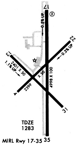
Runways
Runway Summary
| Runways: | 04/22 13/31 17/35 |
| Longest Runway: | 17/35 is 5002 ft (1525 m) long |
| Runways with an Instrument Approach: |
BKD Airport Runway Details
| Runway 04/22 | 2398 ft x 50 ft (731 m x 15 m) | |
| Runway Length Source: | 3RD PARTY SURVEY as of 08/09/2011 | |
| Surface: | Asphalt - Fair condition - No special surface treatment | |
Runway Weight Bearing Capacity (in thousands of pounds) |
||
| Single Wheel Landing Gear: | 4.0 | |
Runway 04 |
Runway 22 |
|
Elevation: |
1263.0 | 1254.3 |
Latitude: |
32-43-00.1817N | 32-43-17.0635N |
Longitude: |
098-53-40.4668W | 098-53-20.7427W |
|
Runway True Alignment: |
045 | 225 |
Glide Path Angle: |
0.0 degrees | 0.0 degrees |
Traffic Pattern: |
Left | Left |
Runway Markings Type: |
Basic | Basic |
Runway Markings Condition: |
Good | Good |
Object at End: |
TREE | TREES |
Object Height: |
20 | 25 |
Distance from End: |
250 | 400 |
Object Centerline Offset: |
85 ft. right of centerline | 0 ft. left and right of centerline |
| Runway 13/31 | 2401 ft x 50 ft (732 m x 15 m) | |
| Runway Length Source: | 3RD PARTY SURVEY as of 08/09/2011 | |
| Surface: | Asphalt - Fair condition - No special surface treatment | |
Runway Weight Bearing Capacity (in thousands of pounds) |
||
| Single Wheel Landing Gear: | 4.0 | |
Runway 13 |
Runway 31 |
|
Elevation: |
1246.9 | 1272.4 |
Latitude: |
32-43-14.2128N | 32-42-57.5335N |
Longitude: |
098-53-43.8027W | 098-53-23.8037W |
|
Runway True Alignment: |
135 | 315 |
Glide Path Angle: |
0.0 degrees | 0.0 degrees |
Traffic Pattern: |
Left | Left |
Runway Markings Type: |
Basic | Basic |
Runway Markings Condition: |
Good | Good |
Object at End: |
TREES | TREES |
Object Height: |
25 | 20 |
Distance from End: |
305 | 200 |
Object Centerline Offset: |
85 ft. right of centerline | 0 ft. left and right of centerline |
Threshold Elevation: |
1272.2 | |
Displaced Threshold: |
120 | |
Threshold Latitude: |
32-42-58.3739N | |
Threshold Longitude: |
098-53-24.8099W |
| Runway 17/35 | 5002 ft x 100 ft (1525 m x 30 m) | |
| Runway Length Source: | STATE as of 11/04/2020 | |
| Surface: | Asphalt - Fair condition - No special surface treatment | |
| Runway Edge Lights: | Medium Intensity | |
Runway Weight Bearing Capacity (in thousands of pounds) |
||
| Single Wheel Landing Gear: | 19.0 | |
Runway 17 |
Runway 35 |
|
Elevation: |
1255.0 | 1284.0 |
Latitude: |
32-43-32.5319N | 32-42-43.0385N |
Longitude: |
098-53-27.5822W | 098-53-27.1983W |
|
Runway True Alignment: |
180 | 360 |
Glide Path Angle: |
3.0 degrees | 3.0 degrees |
Traffic Pattern: |
Left | Left |
Runway Markings Type: |
Nonprecision Instrument | Nonprecision Instrument |
Runway Markings Condition: |
Good | Good |
Object at End: |
TREES | TREES |
Object Height: |
22 | 17 |
Distance from End: |
528 | 201 |
Object Centerline Offset: |
85 ft. right of centerline | 0 ft. left and right of centerline |
Visual Glide Slope Indicators: |
2-Light PAPI On Left Side Of Runway | 2-Light PAPI On Left Side Of Runway |
Threshold Crossing Height: |
40 | 40 |
Services
Airframe Repair: |
Major |
Powerplant Repair: |
Major |
Fuel Available: |
100LL |
Parking: |
Tiedowns available |
Maps & Diagrams
BKD Sectional
Flight Planning
at skyvector.com
at skyvector.com