Location
Latitude: |
42-28-11.8000N (42.469944) |
Longitude: |
071-17-20.4000W (-71.289) |
Elevation: |
132.0 feet MSL (40 m MSL) |
Magnetic Variation: |
14.1 W (as of April 2024 from WMM2020 model) |
Time Zone: |
UTC -5.0 (Standard Time) UTC -4.0 (Daylight Savings Time) |
From City: |
00 N.M. NE of Bedford, Massachusetts |
Found On: |
New York Chart |
FAA Region: |
ANE |
Contacts
Manager: |
Publicly owned: |
| SHARON M. WILLIAMS MASSPORT, 200 HANSCOM DR BEDFORD, MA 01730 617-212-6592 |
MASS PORT AUTHORITY ONE HARBORSIDE DR E BOSTON, MA 02128 617-212-6592 |
Operations
Airport Status: |
Operational |
Facility Use: |
Public |
Type: |
Airport |
Activation Date: |
04/1943 |
Control tower: |
Yes |
Attendance (Months/Days/Hours): |
Months/Days/Hours ALL/ALL/ALL |
Boundary ARTCC: |
ZBW (Boston) |
Responsible ARTCC: |
ZBW (Boston) |
Lighting Schedule: |
SEE RMK |
Segmented Circle Indicator: |
Yes |
Traffic Pattern Altitude (MSL): |
1132 feet (345 m) |
NOTAMs Facility: |
BED |
NOTAM-D Service: |
Yes |
International Airport of Entry: |
No |
Customs Landing Rights: |
No |
Military Landing Rights: |
Yes |
Civil/Military Joint Use: |
No |
Aircraft Rescue and Firefighting: |
Class I ARFF Index: B Air Carrier Service: Scheduled Certification Date: 09/1999 |
Based Aircraft
| Single Engine: | 121 |
| Multi Engine: | 22 |
| Jet Engine: | 68 |
| GA Helicopters: | 11 |
Annual Operations (as of 08/31/2023)
| Total Operations: | 98968 | |
| Commercial: | 579 | 0.6% |
| Air Taxi: | 23516 | 23.8% |
| GA Local: | 30422 | 30.7% |
| GA Itinerant: | 44196 | 44.7% |
| Military Aircraft: | 255 | 0.3% |
Communications
| CTAF: | 118.500 |
| Unicom: | 122.950 |
| Tower: | HANSCOM 118.5 257.2 Hrs: 0700-2300 |
| Clearance Del.: | 121.85 |
| Ground: | 121.7 |
| Approach: | BOSTON |
| Departure: | BOSTON |
| ATIS: | 124.6 Hrs: 24 |
| ASOS: | 124.6 (781-372-5512) |
| EMERG: | 121.5 |
| EMERG: | 243.0 |
| COMD POST: | 362.95 |
Fixed Based Operators (FBOs) & Fuel
(Click on a business for detail)
Please help us keep this information up to date. This is a FREE SERVICE just like everything else on Airport Guide! If you see that a business needs to be added, modified, or deleted please fill out our Update Form.
To add, modify, or delete a business click here.
Please help us keep this information up to date. This is a FREE SERVICE just like everything else on Airport Guide! If you see that a business needs to be added, modified, or deleted please fill out our Update Form.
Area Code: 781 |
| Business Name | Frequency | Phone | Fuel Grade |
|---|---|---|---|
| Aviation Electronics
Website Update FBO info |
274-7070 | ||
| East Coast Aero Club
Website Update FBO info |
274-6322 | ||
| East Coast Aviation
Update FBO info |
274-0105 | ||
| East Coast Aviation
Update FBO info |
274-0105 | ||
| Executive Flyers Aviation, Inc.
Website Update FBO info |
123.50 | 274-7227 | |
| Jet Aviation
Website Update FBO info |
Unicom 122.95 | 274-0030, 800-538-0233 | 100LL, Jet A |

|
 Exxon Avitat |
100LL - 3.36 USD per gallon on 10/13/01 |
Trucks Volume discounts: $0.05/gal for 250-499 gallons $0.15/gal for 500-999 gallons $0.25/gal for 1000-1999 gallons $0.35/gal for 2000+ gallons |
|
|
Exxon Avitat |
Jet A - 2.84 USD per gallon on 10/13/01 |
Trucks Volume discounts: $0.05/gal for 250-499 gallons $0.15/gal for 500-999 gallons $0.25/gal for 1000-1999 gallons $0.35/gal for 2000+ gallons |
| Mercury Air Center
Website Update FBO info |
Unicom 122.95 | 274-0010, 800-367-2961 | 100LL, Jet A |
| Signature Flight Support
Update FBO info |
Unicom: 122.95, Arinc: 130.8 | +1 781 274 0010 |
Flight Service Stations
| Primary | Alternate | |
| FSS on Field: | N | |
| FSS Name (ID): | Bridgeport(BDR) | |
| Frequency: | ||
| Toll Free Phone: | 1-800-WX-BRIEF |
Instrument Procedures / Charts
FAA Terminal Procedures valid from 0901Z 03/21/24 to 0901Z 04/18/24.
There are various types of charts available for an airport. They are listed in the Page Type column. Here is a legend for those types:
APD - Airport Diagram
DP - Departure Procedure Charts
HOT - Hot Spots
IAP - Instrument Approach Procedure Charts
MIN - Minimums
STAR - Standard Terminal Arrival Charts
| Page Type | Page Name | Volume | Action Since Last Cycle |
|---|---|---|---|
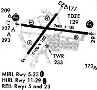
| APD | AIRPORT DIAGRAM | NE-1 | |
| DP | HANSCOM FIVE | NE-1 | |
| DP | HANSCOM FIVE[DELIMITER] CONT.1 | NE-1 | |
| HOT | HOT SPOT | NE-1 | |
| IAP | ILS OR LOC RWY 11 | NE-1 | |
| IAP | ILS OR LOC RWY 29 | NE-1 | |
| IAP | RNAV (GPS) RWY 23 | NE-1 | |
| IAP | RNAV (GPS) Z RWY 11 | NE-1 | |
| IAP | RNAV (GPS) Z RWY 29 | NE-1 | |
| IAP | RNAV (RNP) Y RWY 11 | NE-1 | |
| IAP | RNAV (RNP) Y RWY 29 | NE-1 | |
| LAH | LAHSO | NE-1 | |
| MIN | ALTERNATE MINIMUMS | NE-1 | |
| MIN | TAKEOFF MINIMUMS | NE-1 | |
| STAR | DREEM TWO (RNAV) | NE-1 | |
| STAR | GRAYM SIX | NE-1 | |
| STAR | ZELKA TWO (RNAV) | NE-1 |
Terminal Procedures are only available for airports in several countries with more being added all the time. If you are looking for a specific country's charts, please send an email to support(at)airportguide.com stating the country name. This will be used to prioritize the implementation.
Navigation Aids (Navaids) near BED
| Dist (NM) | ID | Morse Code | Name | Type | Freq | True Hdg | Mag Hdg |
|---|---|---|---|---|---|---|---|
| 0.3 | BED | _ . . . . _ . . | Bedford | VOT | 110.00 | 180 | 194 |
| 4.5 | BE | _ . . . . | Bedds | NDB | 332 | 277 | 291 |
| 5.0 | SKR | . . . _ . _ . _ . | Shaker Hill | NDB | 251 | 99 | 113 |
| 11.2 | LW | . _ . . . _ _ | Haget | NDB | 402 | 21 | 35 |
| 14.5 | LQ | . _ . . _ _ . _ | Lyndy | NDB | 382 | 94 | 108 |
| 14.9 | BOS | _ . . . _ _ _ . . . | Boston | VOT | 111.00 | 117 | 131 |
| 14.9 | BOS | _ . . . _ _ _ . . . | Boston | VOR-DME | 112.70 | 116 | 130 |
| 17.5 | BVY | _ . . . . . . _ _ . _ _ | Beverly | FAN MARKER | 60 | 74 | |
| 18.4 | LWM | . _ . . . _ _ _ _ | Lawrence | DME | 112.5 | 27 | 41 |
| 21.3 | FIT | . . _ . . . _ | Fitchburg | NDB | 365 | 283 | 297 |
| 22.2 | OW | _ _ _ . _ _ | Stoge | NDB | 397 | 161 | 175 |
| 24.2 | MHT | _ _ . . . . _ | Manchester | VOR-DME | 114.40 | 351 | 365 |
| 25.3 | AS | . _ . . . | Chern | NDB | 359 | 327 | 341 |
| 25.9 | MJ | _ _ . _ _ _ | Fitzy | NDB | 209 | 335 | 349 |
| 28.3 | IHM | . . . . . . _ _ | Mansfield | NDB | 220 | 171 | 185 |
| 28.4 | ORH | _ _ _ . _ . . . . . | Worcester | VOT | 108.20 | 244 | 258 |
| 34.3 | GDM | _ _ . _ . . _ _ | Gardner | VOR-DME | 110.60 | 277 | 291 |
| 35.2 | IMR | . . _ _ . _ . | Marshfield | NDB | 368 | 129 | 143 |
| 37.7 | TAN | _ . _ _ . | Taunton | NDB | 227 | 161 | 175 |
| 39.5 | PUT | . _ _ . . . _ _ | Putnam | VOR-DME | 117.40 | 218 | 232 |
Nearby Airports with Fuel
Notices to Airmen (NOTAMS)
Remarks
| A110-1 | PPR FOR ALL ACFT CARRYING EXPLOSIVES CALL 617-212-6592. |
| A110-10 | TWY C, F, J, N, R, S, T, TWY M SOUTH OF TWY E & TWY G BTN RWY 11/29 & RWY 05/23 CLSD TO ACFT GTR THAN 118 FT WINGSPAN. TWY R CLSD TO ACR OPS-GA USE ONLY. |
| A110-14 | NO PLAS/TGLS FOR ACFT UNDER 12500 LBS BTN 2300-0700. |
| A110-16 | SVC-TRAN ALERT: OPR 1200-0400Z++ WKD; 1400-2200Z++ SUN; PPR OT AND HOL DSN 845-5589/5592. DE-ICING AVBL FR VENDOR. |
| A110-18 | AF: PPR ALL MIL ACFT, PAX MNFST REQ ALL INBD PAX, CTC BASE OPS DSN 845-5589/5592, C781-225-5589/5592. |
| A110-19 | AF: COMD POST DSN 845-6960/6961, C781-225-6960/6961. |
| A110-2 | NO PLAS/TGLS FOR ACFT 12500 LBS & OVER. |
| A110-20 | VOLUNTARY NOISE ABATEMENT PROCS IN EFCT CTC AMGR 617-212-6592. NOISE SENSITIVE HISTORIC AREA S OF ARPT; FOR RWY 23 DEP CONT RWY HDG TO 1000 FT AGL, TURNING CROSSWIND OVR RTE 2. |
| A110-21 | PPR FOR MAINT ENG RUN - CTC AMGR. |
| A110-22 | SERVICE: MIL ACFT MUST ARNG FOR PRKG ON EAST RAMP WITH TRAN ALERT OR VENDOR. |
| A110-23 | TWY R1, R2 CLSD TO ACFT GTR THAN 49 FT WINGSPAN. |
| A110-3 | NOISE RULES IN EFCT - HELS OPERG WI CNTLD ASP ARE RQRD TO MNTN HIST PSBL ALT. |
| A110-4 | SUPPORT: OPR 1200-0400Z++ MON-FRI, 1300-1900Z++ SAT & SUN, CLSD HOL. CTC BASE OPS PRIOR TO 1700Z++ FRI FOR OT SUPPORT. |
| A110-6 | BIRDS & WILDLIFE ON & INVOF ARPT. |
| A110-8 | BE ALERT FOR SML ACFT PARKED ON RAMPS. |
| A110-9 | (A23) RWY 29 RIGHT TFC ACFT OVR 12500 LBS. |
| A24 | SURCHARGE FOR EACH LDG & DEP 2300-0700. COML & TSNT LDG FEE. |
| A26 | CLSD TO PART 121 ACR OPS WITH OVER 60 SEATS EXCP 24 HR PPR CALL 781-869-8000. |
| A81-APT | ACTVT MALSR RWY 11 & 29; REIL RWY 05 & 23; HIRL RWY 11/29; MIRL RWY 05/23; TWY LGTS - 118.5. |
| E147 | 1000 FT AGL FIXED WING; 1500 FT AGL TURBOJET; 1800 FT AGL HEAVY JET ACFT. |
| E80 | US CUSTOMS USER FEE ARPT. |
Runways
Runway Summary
| Runways: | 05/23 11/29 |
| Longest Runway: | 11/29 is 7011 ft (2137 m) long |
| Runways with an Instrument Approach: | 11, 29 |
BED Airport Runway Details
| Runway 05/23 | 5107 ft x 150 ft (1557 m x 46 m) | |
| Runway Length Source: | 3RD PARTY SURVEY as of 05/26/2010 | |
| Surface: | Asphalt - Good condition - Saw-cut or plastic grooved | |
| Runway Pavement Class: | 79 /F/C/W/T | |
| Runway Edge Lights: | Medium Intensity | |
Runway Weight Bearing Capacity (in thousands of pounds) |
||
| Single Wheel Landing Gear: | 120.0 | |
| Dual Wheel Landing Gear: | 250.0 | |
| Dual Tandem Wheel Landing Gear: | 436.0 | |
Runway 05 |
Runway 23 |
|
Elevation: |
128.0 | 127.8 |
Latitude: |
42-27-48.3688N | 42-28-28.5910N |
Longitude: |
071-17-48.7253W | 071-17-07.5937W |
|
Runway True Alignment: |
037 | 217 |
Glide Path Angle: |
3.5 degrees | 3.2 degrees |
Traffic Pattern: |
Left | Left |
Runway Markings Type: |
Nonprecision Instrument | Nonprecision Instrument |
Runway Markings Condition: |
Good | Good |
Visual Glide Slope Indicators: |
4-Light PAPI On Left Side Of Runway | 4-Light PAPI On Right Side Of Runway |
REIL: |
Yes | Yes |
Touchdown Lights: |
No | No |
Centerline Lights: |
No | No |
Threshold Crossing Height: |
55 | 55 |
Declared Distances |
||
Take Off Run Avbl. (TORA): |
5107 | 5107 |
Take Off Distance Avbl. (TODA): |
5107 | 5107 |
Actual Stop Dist. Avbl. (ASDA): |
5107 | 5107 |
Landing Dist. Avbl. (LDA): |
5107 | 5107 |
| Runway 11/29 | 7011 ft x 150 ft (2137 m x 46 m) | |
| Runway Length Source: | 3RD PARTY SURVEY as of 05/26/2010 | |
| Surface: | Asphalt - Good condition - Saw-cut or plastic grooved | |
| Runway Pavement Class: | 82 /F/C/W/T | |
| Runway Edge Lights: | High Intensity | |
Runway Weight Bearing Capacity (in thousands of pounds) |
||
| Single Wheel Landing Gear: | 120.0 | |
| Dual Wheel Landing Gear: | 250.0 | |
| Dual Tandem Wheel Landing Gear: | 455.0 | |
Runway 11 |
Runway 29 |
|
Elevation: |
132.0 | 123.0 |
Latitude: |
42-28-18.5654N | 42-28-09.9695N |
Longitude: |
071-18-01.2347W | 071-16-28.4156W |
|
Runway True Alignment: |
097 | 277 |
ILS Type: |
ILS/DME | ILS/DME |
Glide Path Angle: |
3.0 degrees | 3.0 degrees |
Traffic Pattern: |
Left | Left |
Runway Markings Type: |
Precision Instrument | Precision Instrument |
Runway Markings Condition: |
Good | Good |
Object at End: |
HILL | |
Object Height: |
120 | |
Object Marked/Lighted?: |
Lighted | |
Distance from End: |
1050 | |
Visual Glide Slope Indicators: |
4-Light PAPI On Left Side Of Runway | 4-Light PAPI On Right Side Of Runway |
Runway Visual Range (RVR): |
Touchdown | Rollout |
Approach Light System: |
1,400 Foot Medium Intensity Approach Lighting System With Runway Alignment Indicator Lights | 1,400 Foot Medium Intensity Approach Lighting System With Runway Alignment Indicator Lights |
REIL: |
No | No |
Touchdown Lights: |
No | No |
Centerline Lights: |
No | No |
Threshold Crossing Height: |
67 | 52 |
Declared Distances |
||
Take Off Run Avbl. (TORA): |
7011 | 7011 |
Take Off Distance Avbl. (TODA): |
7011 | 7011 |
Actual Stop Dist. Avbl. (ASDA): |
7011 | 7011 |
Landing Dist. Avbl. (LDA): |
7011 | 7011 |
Services
Airframe Repair: |
Major |
Powerplant Repair: |
Major |
Bottled Oxygen: |
Low Pressure |
Bulk Oxygen: |
Low Pressure |
Fuel Available: |
100LL, Jet A |
Landing Fees: |
No |
Parking: |
Hangars and tiedowns available |
Maps & Diagrams
BED Sectional
Flight Planning
at skyvector.com
at skyvector.com