
Location
Latitude: |
32-21-50.5000N (32.364028) |
Longitude: |
064-40-43.3000W (-64.678694) |
Elevation: |
18.4 feet MSL (6 m MSL) |
Magnetic Variation: |
14.5 W (as of April 2024 from WMM2020 model) |
Time Zone: |
UTC -4.0 (Standard Time) UTC -3.0 (Daylight Savings Time) |
From City: |
06 N.M. NE of Hamilton, Bermuda |
Contacts
Manager: |
Publicly owned: |
| AIRPORT GENERAL MANAGER DEPARTMENT OF AERODROME OPERATIONS, 3 CAHOW WAY ST GEORGES GE CX 1-441-293-2470 |
Operations
Airport Status: |
Operational |
Facility Use: |
Public |
Type: |
Airport |
Control tower: |
Yes |
Attendance (Months/Days/Hours): |
Months/Days/Hours ALL/ALL/ALL |
Boundary ARTCC: |
ZNY (New York) |
Responsible ARTCC: |
ZNY (New York) |
Lighting Schedule: |
SEE RMK |
Traffic Pattern Altitude (MSL): |
1018 feet (310 m) |
International Airport of Entry: |
No |
Based Aircraft
Annual Operations (as of )
Communications
| Unicom: | 122.800 |
| Tower: | BERMUDA 118.1 Hrs: 1100-0300Z++ UTC-4(-3DT) |
| Clearance Del.: | 124.5 |
| Ground: | 124.5 |
| ATIS: | 119.6 Hrs: 24 |
| AWOS-3PT: | 119.6 |
- APCH/DEP SVC PRVDD BY NEW YORK APCH 119.1.
- CD SVC PRVDD BY NEW YORK ARTCC 128.5 WHEN ATCT CLSD.
- (AIRSPACE_HRS) CLASS E AIRSPACE OTR HR.
Fixed Based Operators (FBOs) & Fuel
(Click on a business for detail)
Please help us keep this information up to date. This is a FREE SERVICE just like everything else on Airport Guide! If you see that a business needs to be added, modified, or deleted please fill out our Update Form.
To add, modify, or delete a business click here.
Please help us keep this information up to date. This is a FREE SERVICE just like everything else on Airport Guide! If you see that a business needs to be added, modified, or deleted please fill out our Update Form.
| Business Name | Frequency | Phone | Fuel Grade |
|---|
Flight Service Stations
| Primary | Alternate | |
| FSS on Field: | ||
| FSS Name (ID): | New York(ISP) | |
| Frequency: | ||
| Toll Free Phone: | 1-800-WX-BRIEF |
Instrument Procedures / Charts
Terminal Procedures are only available for airports in several countries with more being added all the time. If you are looking for a specific country's charts, please send an email to support(at)airportguide.com stating the country name. This will be used to prioritize the implementation.
Navigation Aids (Navaids) near BDA
| Dist (NM) | ID | Morse Code | Name | Type | Freq | True Hdg | Mag Hdg |
|---|---|---|---|---|---|---|---|
| 0.6 | BDA | _ . . . _ . . . _ | Bermuda | VOR-DME | 113.90 | 272 | 287 |
Nearby Airports with Fuel
| Dist (NM) | Name (Airport IDs) | True Hdg | Mag Hdg | Fuel Grade |
|---|
Notices to Airmen (NOTAMS)
Remarks
| A110-1 | 180 DEG TURNS ON RY 12/30 PROHIBITED UNLESS INSTRUCTED BY ATC. |
| A110-2 | ACFT MOVEMENTS ON APRON ARE UNCONTROLLED. |
| A110-3 | ACFT FLT PROHIBITED WI 3NM OF RSTR AREA R-3017. |
| A110-4 | FIREFIGHT EQUIP: FOUR FOAM VEHICLES: EACH, 3,000 GALS WATER, 420 GALS FOAM, 500 LBS DRY CHEM; ONE FOAM VEHICLE, 1,500 GALS WATER, 210 GALS FOAM; ONE LIGHT RESCUE VEHICLE & ONE COMMAND VEHICLE AVBL 1100-0300Z++ UTC-4 (-3DT). |
| A110-5 | WILDLIFE CTL SVC UNAVBL 0300-1100Z++ UTC-4(-3DT). |
| A110-6 | POTENTIAL FOR LGT TO MOD TURBULENCE AND/OR WIND SHEAR ON APCH RY 30. |
| A18 | FOREIGN CIV GOVT. LNDG FEES & DIPLOMATIC CLNC MAY BE RQR. |
| A43-12 | RY 12 PAPI UNUSBL 9 DEG RIGHT AND 9 DEG LEFT OF CNTRLN. |
| A76 | LIMITED. |
| A81-APT | WHEN ATCT CLSD, ACTVT MIRL RY 12/30, PAPI RYS 12 & 30, REIL RY 12, SALS RY 12 & ALSF-1 RY 30 - 122.8. |
| A86 | LCL AIS BRF ON APRT. |
Runways
Runway Summary
| Runways: | 12/30 |
| Longest Runway: | 12/30 is 9706 ft (2958 m) long |
| Runways with an Instrument Approach: |
BDA Airport Runway Details
| Runway 12/30 | 9706 ft x 150 ft (2958 m x 46 m) | |
| Runway Length Source: | 3RD PARTY SURVEY as of 09/24/2013 | |
| Surface: | Asphalt/Concrete - No special surface treatment | |
| Runway Pavement Class: | 80 /F/A/W/U | |
| Runway Edge Lights: | High Intensity | |
Runway 12 |
Runway 30 |
|
Elevation: |
17.8 | 18.0 |
Latitude: |
32-22-00.0819N | 32-21-41.0040N |
Longitude: |
064-41-38.7111W | 064-39-47.8128W |
|
Runway True Alignment: |
101 | 281 |
Glide Path Angle: |
3.4 degrees | 3.0 degrees |
Visual Glide Slope Indicators: |
4-Light PAPI On Right Side Of Runway | 4-Light PAPI On Left Side Of Runway |
Approach Light System: |
Standard 2,400 Foot High Intensity Approach Lighting System With Sequenced Flashers, Cat. I Config. | |
REIL: |
Yes | |
Touchdown Lights: |
Yes | Yes |
Centerline Lights: |
Yes | Yes |
Threshold Crossing Height: |
50 | 65 |
Threshold Elevation: |
17.8 | |
Displaced Threshold: |
579 | |
Threshold Latitude: |
32-21-58.9455N | |
Threshold Longitude: |
064-41-32.1004W | |
Declared Distances |
||
Take Off Run Avbl. (TORA): |
9669 | 9669 |
Take Off Distance Avbl. (TODA): |
10620 | 10243 |
Actual Stop Dist. Avbl. (ASDA): |
9669 | 9669 |
Landing Dist. Avbl. (LDA): |
9669 | 9669 |
Services
Fuel Available: |
Jet A-1 |
Maps & Diagrams
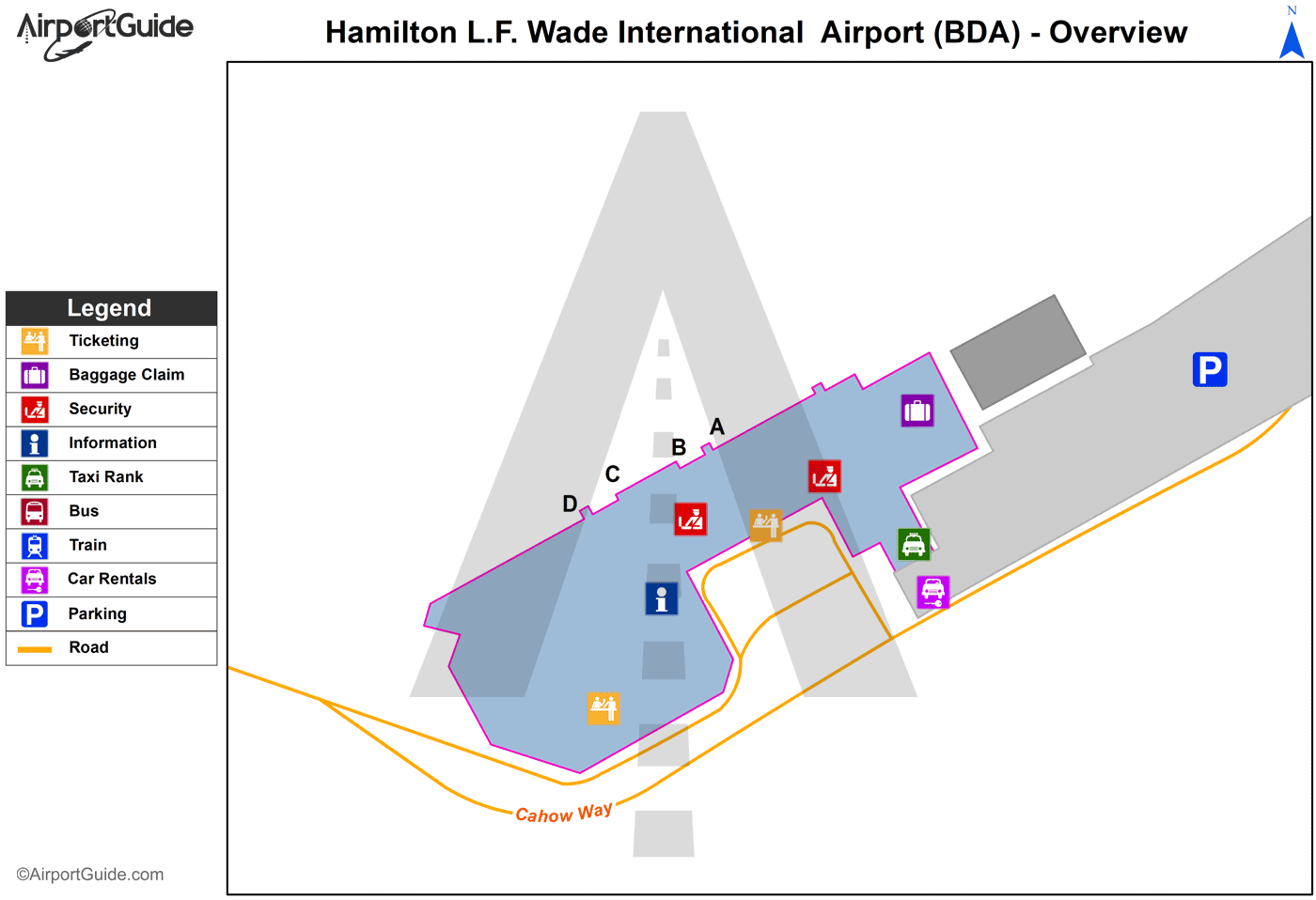
BDA Sectional
Flight Planning
at skyvector.com
at skyvector.com
