Location
Latitude: |
47-12-41.8000N (47.211611) |
Longitude: |
119-50-23.4000W (-119.839833) |
Elevation: |
1271.1 feet MSL (387 m MSL) |
Magnetic Variation: |
14.6 E (as of April 2024 from WMM2020 model) |
Time Zone: |
UTC -8.0 (Standard Time) UTC -7.0 (Daylight Savings Time) |
From City: |
02 N.M. SE of Quincy, Washington |
Found On: |
Seattle Chart |
FAA Region: |
ANM |
Contacts
Manager: |
Publicly owned: |
| PAT CONNELLY PORT OF QUINCY, 101 F STREET SW QUINCY, WA 98848 509-787-3715 |
CITY OF QUINCY 101 F STREET SW QUINCY, WA 98848 509-787-3715 |
Operations
Airport Status: |
Operational |
Facility Use: |
Public |
Type: |
Airport |
Activation Date: |
03/1979 |
Control tower: |
No |
Attendance (Months/Days/Hours): |
Months/Days/Hours Unattended |
Boundary ARTCC: |
ZSE (Seattle) |
Responsible ARTCC: |
ZSE (Seattle) |
Lighting Schedule: |
SS-SR |
Segmented Circle Indicator: |
No |
Traffic Pattern Altitude (MSL): |
2271 feet (692 m) |
NOTAMs Facility: |
SEA |
NOTAM-D Service: |
Yes |
Military Landing Rights: |
Yes |
Based Aircraft
| Single Engine: | 6 |
Annual Operations (as of 12/31/2021)
| Total Operations: | 1700 | |
| GA Local: | 700 | 41.2% |
| GA Itinerant: | 1000 | 58.8% |
Communications
| CTAF: | 122.900 |
- APCH/DEP SVC PRVDD BY SEATTLE ARTCC ON FREQS 126.1/291.6 (MARLIN RCAG) WHEN GRANT COUNTY APCH CTL CLSD.
Fixed Based Operators (FBOs) & Fuel
(Click on a business for detail)
Please help us keep this information up to date. This is a FREE SERVICE just like everything else on Airport Guide! If you see that a business needs to be added, modified, or deleted please fill out our Update Form.
To add, modify, or delete a business click here.
Please help us keep this information up to date. This is a FREE SERVICE just like everything else on Airport Guide! If you see that a business needs to be added, modified, or deleted please fill out our Update Form.
Area Code: 509 |
| Business Name | Frequency | Phone | Fuel Grade |
|---|
Flight Service Stations
| Primary | Alternate | |
| FSS on Field: | N | |
| FSS Name (ID): | Seattle(SEA) | |
| Frequency: | ||
| Toll Free Phone: | 1-800-WX-BRIEF |
Instrument Procedures / Charts
Terminal Procedures are only available for airports in several countries with more being added all the time. If you are looking for a specific country's charts, please send an email to support(at)airportguide.com stating the country name. This will be used to prioritize the implementation.
Navigation Aids (Navaids) near 80T
| Dist (NM) | ID | Morse Code | Name | Type | Freq | True Hdg | Mag Hdg |
|---|---|---|---|---|---|---|---|
| 18.8 | EAT | . . _ _ | Wenatchee | VOR-DME | 111.00 | 306 | 291 |
| 19.6 | EPH | . . _ _ . . . . . | Ephrata | VORTAC | 112.60 | 59 | 44 |
| 21.3 | MWH | _ _ . _ _ . . . . | Moses Lake | VOR-DME | 115.00 | 89 | 74 |
| 23.8 | MW | _ _ . _ _ | Pelly | NDB | 408 | 103 | 88 |
| 27.6 | ELN | . . _ . . _ . | Ellensburg | VOR-DME | 117.90 | 246 | 231 |
| 45.8 | YKM | _ . _ _ _ . _ _ _ | Yakima | VORTAC | 116.00 | 213 | 198 |
| 46.6 | YK | _ . _ _ _ . _ | Donny | NDB | 371 | 208 | 193 |
| 63.8 | PSC | . _ _ . . . . _ . _ . | Pasco | VOR-DME | 113.75 | 151 | 137 |
| 75.6 | OMK | _ _ _ _ _ _ . _ | Omak | NDB | 219 | 9 | 354 |
| 91.6 | SKA | . . . _ . _ . _ | Fairchild | TACAN | 111.40 | 74 | 60 |
| 91.9 | AL | . _ . _ . . | Trina | NDB | 353 | 131 | 117 |
| 92.4 | GEG | _ _ . . _ _ . | Spokane | VORTAC | 115.50 | 75 | 61 |
| 92.8 | ALW | . _ . _ . . . _ _ | Walla Walla | VOR-DME | 116.40 | 136 | 122 |
| 96.9 | GEG | _ _ . . _ _ . | Spokane Intl | VOT | 109.60 | 74 | 60 |
| 98.0 | RNT | . _ . _ . _ | Renton | NDB | 353 | 280 | 265 |
| 98.1 | PDT | . _ _ . _ . . _ | Pendleton | VORTAC | 114.70 | 157 | 143 |
Nearby Airports with Fuel
Notices to Airmen (NOTAMS)
Remarks
| A11 | LESSOR: GRANT CO PORT DIST NO 1. |
| A110*G | THIS AIRPORT HAS BEEN SURVEYED BY THE NATIONAL GEODETIC SURVEY. |
| A110-2 | GRVL ROADS CROSS RY 27 2175' FM APCH END WHERE DITCHES PASS UNDER RY. |
| A110-3 | BERMS, BRUSH, ROADS, FENCES AND -20 FT DITCHES IN PRIM SFC. |
| A110-4 | TWYS MARKED WITH REFLECTIVE DEVICES. |
| A110-5 | FOR CD CTC SEATTLE ARTCC AT 253-351-3694. |
| A110-6 | 15 FT HI IRRIGATION PIVOT POINT W SIDE OF RWY, MID-FLD. |
| A58-27 | RWY 27 +4 FT FENCE AT 133 FT FM TRD; 4 FT FENCE, 101 FT L, EVEN WITH THR. |
| A75 | PILOTS BRING OWN ROPES. |
Runways
Runway Summary
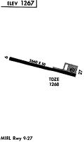
| Runways: | 09/27 |
| Longest Runway: | 09/27 is 3660 ft (1116 m) long |
| Runways with an Instrument Approach: |
80T Airport Runway Details
| Runway 09/27 | 3660 ft x 50 ft (1116 m x 15 m) | |
| Runway Length Source: | NGS as of 08/15/1997 | |
| Surface: | Asphalt - Good condition - Aggregate friction seal coat | |
| Runway Edge Lights: | Medium Intensity | |
Runway 09 |
Runway 27 |
|
Elevation: |
1270.6 | 1260.2 |
Latitude: |
47-12-46.7936N | 47-12-36.7264N |
Longitude: |
119-50-48.8501W | 119-49-57.9372W |
|
Runway True Alignment: |
106 | 286 |
Glide Path Angle: |
0.0 degrees | 0.0 degrees |
Runway Markings Type: |
Basic | Basic |
Runway Markings Condition: |
Good | Good |
Object at End: |
ROAD | TREE |
Object Height: |
18 | 54 |
Distance from End: |
200 | 340 |
Object Centerline Offset: |
48 ft. left of centerline | 125 ft. right of centerline |
Threshold Elevation: |
1262.5 | |
Displaced Threshold: |
200 | |
Threshold Latitude: |
47-12-37.3000N | |
Threshold Longitude: |
119-50-00.7700W | |
Declared Distances |
||
Take Off Run Avbl. (TORA): |
3460 | 3660 |
Take Off Distance Avbl. (TODA): |
3460 | 3660 |
Actual Stop Dist. Avbl. (ASDA): |
3660 | 3460 |
Landing Dist. Avbl. (LDA): |
3660 | 3460 |
Services
Airframe Repair: |
None |
Powerplant Repair: |
None |
Bottled Oxygen: |
None |
Bulk Oxygen: |
None |
Fuel Available: |
100LL, Jet A+ |
Landing Fees: |
No |
Parking: |
Tiedowns available |
Maps & Diagrams
80T Sectional
Flight Planning
at skyvector.com
at skyvector.com