Location
Latitude: |
41-22-27.3710N (41.37427) |
Longitude: |
084-04-04.3650W (-84.067879) |
Elevation: |
682.9 feet MSL (208 m MSL) |
Magnetic Variation: |
6.7 W (as of April 2024 from WMM2020 model) |
Time Zone: |
UTC -5.0 (Standard Time) UTC -4.0 (Daylight Savings Time) |
From City: |
03 N.M. E of Napoleon, Ohio |
Found On: |
Detroit Chart |
FAA Region: |
AGL |
Contacts
Manager: |
Publicly owned: |
| JARED AMES, ACTING AMGR 10646 COUNTY ROAD O NAPOLEON, OH 43545-6217 419-599-6494 |
HENRY CO ARPT AUTH 10646 COUNTY ROAD O NAPOLEON, OH 43545-6217 419-599-6494 |
Operations
Airport Status: |
Operational |
Facility Use: |
Public |
Type: |
Airport |
Activation Date: |
11/1971 |
Control tower: |
No |
Attendance (Months/Days/Hours): |
Months/Days/Hours ALL/MON-FRI/0800-1730 |
Boundary ARTCC: |
ZOB (Cleveland) |
Responsible ARTCC: |
ZOB (Cleveland) |
Lighting Schedule: |
SEE RMK |
Segmented Circle Indicator: |
No |
Traffic Pattern Altitude (MSL): |
1683 feet (513 m) |
NOTAMs Facility: |
CLE |
NOTAM-D Service: |
Yes |
International Airport of Entry: |
No |
Customs Landing Rights: |
No |
Military Landing Rights: |
No |
Civil/Military Joint Use: |
No |
Based Aircraft
| Single Engine: | 15 |
| Multi Engine: | 1 |
Annual Operations (as of 10/03/2023)
| Total Operations: | 5520 | |
| Air Taxi: | 10 | 0.2% |
| GA Local: | 5000 | 90.6% |
| GA Itinerant: | 500 | 9.1% |
| Military Aircraft: | 10 | 0.2% |
Communications
| CTAF: | 123.000 |
| Unicom: | 123.000 |
| Approach: | TOLEDO 134.35 134.35 |
| Departure: | TOLEDO 134.35 134.35 |
Fixed Based Operators (FBOs) & Fuel
(Click on a business for detail)
Please help us keep this information up to date. This is a FREE SERVICE just like everything else on Airport Guide! If you see that a business needs to be added, modified, or deleted please fill out our Update Form.
To add, modify, or delete a business click here.
Please help us keep this information up to date. This is a FREE SERVICE just like everything else on Airport Guide! If you see that a business needs to be added, modified, or deleted please fill out our Update Form.
Area Code: 419 |
| Business Name | Frequency | Phone | Fuel Grade |
|---|---|---|---|
| Classic Aviation Helicopters
Update FBO info |
Unicom 123.0 | 592-4008 | 100LL, Jet A |
Flight Service Stations
| Primary | Alternate | |
| FSS on Field: | N | |
| FSS Name (ID): | Cleveland(CLE) | |
| Frequency: | ||
| Toll Free Phone: | 1-800-WX-BRIEF |
Instrument Procedures / Charts
FAA Terminal Procedures valid from 0901Z 03/21/24 to 0901Z 04/18/24.
There are various types of charts available for an airport. They are listed in the Page Type column. Here is a legend for those types:
APD - Airport Diagram
DP - Departure Procedure Charts
HOT - Hot Spots
IAP - Instrument Approach Procedure Charts
MIN - Minimums
STAR - Standard Terminal Arrival Charts
| Page Type | Page Name | Volume | Action Since Last Cycle |
|---|---|---|---|
| IAP | RNAV (GPS) RWY 28 | EC-2 | |
| MIN | TAKEOFF MINIMUMS | EC-2 |
Terminal Procedures are only available for airports in several countries with more being added all the time. If you are looking for a specific country's charts, please send an email to support(at)airportguide.com stating the country name. This will be used to prioritize the implementation.
Navigation Aids (Navaids) near 7W5
| Dist (NM) | ID | Morse Code | Name | Type | Freq | True Hdg | Mag Hdg |
|---|---|---|---|---|---|---|---|
| 12.6 | TO | _ _ _ _ | Tophr | NDB | 219 | 31 | 38 |
| 14.4 | USE | . . _ . . . . | Fulton | NDB | 375 | 348 | 355 |
| 17.9 | TOL | _ _ _ _ . _ . . | Toledo | TACAN | 112.50 | 42 | 49 |
| 19.9 | VWV | . . . _ . _ _ . . . _ | Waterville | VOR-DME | 113.10 | 76 | 83 |
| 27.8 | BNR | _ . . . _ . . _ . | Benton Ridge | NDB | 334 | 139 | 146 |
| 28.8 | FBC | . . _ . _ . . . _ . _ . | Flag City | VORTAC | 108.20 | 150 | 157 |
| 29.7 | ADG | . _ _ . . _ _ . | Adrian | NDB | 278 | 359 | 366 |
| 32.2 | FZI | . . _ . _ _ . . . . | Fostoria | NDB | 379 | 109 | 116 |
| 39.4 | VFU | . . . _ . . _ . . . _ | Stanley | NDB | 411 | 219 | 225 |
| 39.7 | GW | _ _ . . _ _ | Shenk | NDB | 227 | 264 | 270 |
| 40.3 | AOH | . _ _ _ _ . . . . | Allen County | VOR | 108.40 | 173 | 180 |
| 40.4 | TCU | _ _ . _ . . . _ | Tecumseh | NDB | 239 | 11 | 18 |
| 42.0 | TII | _ . . . . | Tiffin | NDB | 269 | 113 | 120 |
| 48.5 | ANQ | . _ _ . _ _ . _ | Angola | NDB | 347 | 289 | 295 |
| 48.8 | CRL | _ . _ . . _ . . _ . . | Carleton | VOR-DME | 115.70 | 33 | 40 |
| 51.8 | LFD | . _ . . . . _ . _ . . | Litchfield | VOR-DME | 111.20 | 323 | 330 |
| 54.6 | PCW | . _ _ . _ . _ . . _ _ | Port Clinton | NDB | 423 | 80 | 87 |
| 55.9 | FWA | . . _ . . _ _ . _ | Fort Wayne | VORTAC | 117.80 | 245 | 251 |
| 55.9 | JXN | . _ _ _ _ . . _ _ . | Jackson | DME | 115.45 | 341 | 348 |
| 56.0 | FWA | . . _ . . _ _ . _ | Fort Wayne Baer | VOT | 111.00 | 245 | 251 |
Nearby Airports with Fuel
Notices to Airmen (NOTAMS)
Remarks
| A110-1 | FOR CD CTC TOLEDO APCH AT 419-865-1495. |
| A16 | CELL 419-388-9259. |
| A17 | FOR SVC CALL AMGR CELL. |
| A57-10 | CTLG OBSTN EXCEEDS A 45 DEG SLP. |
| A57-28 | CTLG OBSTN EXCEEDS A 45 DEG SLP. |
| A58-10 | +5 FT CROPS/CULTIVATED FLD, 140-200 FT DIST, 95-125 FT R. |
| A58-28 | +6 FT CROPS/CULTIVATED FLD, 0-200 FT DIST, 125 FT L TO 130 FT R. |
| A75 | PRIOR CDN RQRD. |
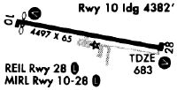
| A81-APT | ACTVT REIL RWY 10 & 28; PAPI RWY 10 & 28; MIRL RWY 10/28 - CTAF. |
Runways
Runway Summary
| Runways: | 10/28 |
| Longest Runway: | 10/28 is 4001 ft (1220 m) long |
| Runways with an Instrument Approach: |
7W5 Airport Runway Details
| Runway 10/28 | 4001 ft x 60 ft (1220 m x 18 m) | |
| Runway Length Source: | 3RD PARTY SURVEY as of 12/22/2020 | |
| Surface: | Asphalt - Excellent condition - No special surface treatment | |
| Runway Edge Lights: | Medium Intensity | |
Runway 10 |
Runway 28 |
|
Elevation: |
680.8 | 682.8 |
Latitude: |
41-22-31.0595N | 41-22-23.6801N |
Longitude: |
084-04-30.1408W | 084-03-38.5906W |
|
Runway True Alignment: |
101 | 281 |
Glide Path Angle: |
3.0 degrees | 3.0 degrees |
Traffic Pattern: |
Left | |
Runway Markings Type: |
Nonprecision Instrument | Nonprecision Instrument |
Runway Markings Condition: |
Good | Good |
Object at End: |
CROPS | CROPS |
Object Height: |
5 | 6 |
Distance from End: |
200 | 200 |
Object Centerline Offset: |
95 ft. right of centerline | 125 ft. left of centerline |
Visual Glide Slope Indicators: |
2-Light PAPI On Left Side Of Runway | 2-Light PAPI On Left Side Of Runway |
REIL: |
Yes | Yes |
Touchdown Lights: |
No | No |
Centerline Lights: |
No | No |
Threshold Crossing Height: |
25 | 25 |
Services
Airframe Repair: |
Major |
Powerplant Repair: |
Major |
Bottled Oxygen: |
High Pressure |
Bulk Oxygen: |
High Pressure |
Fuel Available: |
100LL, Jet A+ |
Landing Fees: |
No |
Parking: |
Hangars and tiedowns available |
Maps & Diagrams
7W5 Sectional
Flight Planning
at skyvector.com
at skyvector.com