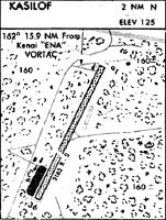
Location
Latitude: |
60-21-01.8750N (60.350521) |
Longitude: |
151-15-46.2830W (-151.262856) |
Elevation: |
125.0 feet MSL (38 m MSL) |
Magnetic Variation: |
14.2 E (as of April 2024 from WMM2020 model) |
Time Zone: |
UTC -9.0 (Standard Time) UTC -8.0 (Daylight Savings Time) |
From City: |
02 N.M. N of Kasilof, Alaska |
Found On: |
Anchorage Chart |
FAA Region: |
AAL |
Contacts
Manager: |
Publicly owned: |
| ROB SMITH PO BOX 1327 SOLDOTNA, AK 99669 907-953-6733 |
ALASKA DOT&PF CENTRAL REGION PO BOX 196900 ANCHORAGE, AK 99519-6900 (907) 269-0760 |
Operations
Airport Status: |
Operational |
Facility Use: |
Public |
Type: |
Airport |
Activation Date: |
05/1947 |
Control tower: |
No |
Attendance (Months/Days/Hours): |
Months/Days/Hours Unattended |
Boundary ARTCC: |
ZAN (Anchorage) |
Responsible ARTCC: |
ZAN (Anchorage) |
Segmented Circle Indicator: |
Yes |
Traffic Pattern Altitude (MSL): |
1125 feet (343 m) |
NOTAMs Facility: |
ENA |
NOTAM-D Service: |
Yes |
International Airport of Entry: |
No |
Customs Landing Rights: |
No |
Military Landing Rights: |
Yes |
Civil/Military Joint Use: |
No |
Based Aircraft
| Single Engine: | 1 |
Annual Operations (as of 12/31/2022)
Communications
| CTAF: | 122.500 |
Fixed Based Operators (FBOs) & Fuel
(Click on a business for detail)
Please help us keep this information up to date. This is a FREE SERVICE just like everything else on Airport Guide! If you see that a business needs to be added, modified, or deleted please fill out our Update Form.
To add, modify, or delete a business click here.
Please help us keep this information up to date. This is a FREE SERVICE just like everything else on Airport Guide! If you see that a business needs to be added, modified, or deleted please fill out our Update Form.
Area Code: 907 |
| Business Name | Frequency | Phone | Fuel Grade |
|---|
Flight Service Stations
| Primary | Alternate | |
| FSS on Field: | N | |
| FSS Name (ID): | Kenai(ENA) | |
| Frequency: | ||
| Toll Free Phone: | 1-866-864-1737 |
Instrument Procedures / Charts
Terminal Procedures are only available for airports in several countries with more being added all the time. If you are looking for a specific country's charts, please send an email to support(at)airportguide.com stating the country name. This will be used to prioritize the implementation.
Navigation Aids (Navaids) near 5KS
| Dist (NM) | ID | Morse Code | Name | Type | Freq | True Hdg | Mag Hdg |
|---|---|---|---|---|---|---|---|
| 13.6 | OLT | _ _ _ . _ . . _ | Soldotna | NDB-DME | 346 | 56 | 42 |
| 15.0 | IWW | . . . _ _ . _ _ | Wildwood | NDB | 379 | 5 | 351 |
| 16.0 | ENA | . _ . . _ | Kenai | VOR-DME | 117.60 | 7 | 353 |
| 38.9 | HOM | . . . . _ _ _ _ _ | Homer | VOR-DME | 114.60 | 188 | 174 |
| 43.1 | ACE | . _ _ . _ . . | Kachemak | NDB | 277 | 189 | 175 |
| 60.8 | CMQ | _ . _ . _ _ _ _ . _ | Campbell Lake | NDB | 338 | 35 | 21 |
| 61.5 | ANC | . _ _ . _ . _ . | Anchorage | VOT | 108.40 | 36 | 22 |
| 62.2 | TED | _ . _ . . | Anchorage | VOR-DME | 113.15 | 37 | 23 |
| 66.5 | MRI | _ _ . _ . . . | Anchorage | VOT | 111.00 | 38 | 24 |
| 69.7 | EDF | . _ . . . . _ . | Elmendorf | TACAN | 113.40 | 38 | 24 |
| 82.3 | BGQ | _ . . . _ _ . _ _ . _ | Big Lake | VORTAC | 112.50 | 26 | 12 |
Nearby Airports with Fuel
| Dist (NM) | Name (Airport IDs) | True Hdg | Mag Hdg | Fuel Grade |
|---|---|---|---|---|
| 10.0 | Soldotna Airport (SXQ PASX SXQ) |
41 | 27 | 100LL, Jet A |
| 13.4 | Kenai Municipal Airport (ENA PAEN ENA) |
2 | 348 | 100LL, Jet A |
| 42.9 | Homer Airport (HOM PAHO HOM) |
189 | 175 | 100LL, Jet A |
| 43.2 | Homer-Beluga Lake Seaplane Base (5BL) |
190 | 176 | 100LL |
| 61.8 | Ted Stevens Anchorage International Airport (ANC PANC ANC) |
36 | 21 | 100, 100LL, Jet A, Jet A-1 |
| 66.4 | Merrill Field Airport (MRI PAMR MRI) |
38 | 23 | 100, Jet A |
| 66.7 | Alaska Regional Hospital Heliport (2OK) |
38 | 23 | 100LL, Jet A |
| 81.9 | Birchwood Airport (PABV BCV) |
37 | 22 | 100LL |
| 88.8 | Wasilla Airport (WWA PAWS IYS) |
33 | 18 | 100LL, Jet A |
| 91.7 | Wasilla Lake Seaplane Base (5L6) |
35 | 20 | 100LL |
| 97.9 | Warren 'Bud' Woods Palmer Municipal Airport (PAQ PAAQ PAQ) |
39 | 24 | 100LL, Jet A-1 |
Notices to Airmen (NOTAMS)
Remarks
| A110-2 | RWY COND UNMNT; RCMND VISUAL INSP PRIOR TO USE. |
| A110-3 | KENAI FSS - 283-7211. |
| A110-5 | MAINT IREG. |
| A110-7 | ATV TFC ON RWY. |
| A110-8 | PRKG AREA S END. |
| A33-01/19 | 3 IN RUTS. |
| A42-01 | RWY EDGE NOT MKD. |
| A83 | WINDSOCK BLW TREE LINE & MAY BE UNRELBL. |
Runways
Runway Summary
| Runways: | 01/19 |
| Longest Runway: | 01/19 is 2400 ft (732 m) long |
| Runways with an Instrument Approach: |
5KS Airport Runway Details
| Runway 01/19 | 2400 ft x 60 ft (732 m x 18 m) | |
| Runway Length Source: | ADO as of 07/29/2014 | |
| Surface: | Gravel - Good condition - No special surface treatment | |
Runway 01 |
Runway 19 |
|
Elevation: |
104.0 | 106.5 |
Latitude: |
60-20-51.5300N | 60-21-12.2200N |
Longitude: |
151-15-57.8100W | 151-15-34.7600W |
|
Runway True Alignment: |
029 | 209 |
Glide Path Angle: |
0.0 degrees | 0.0 degrees |
Traffic Pattern: |
Left | Left |
Object at End: |
TREES | BRUSH |
Object Height: |
60 | 4 |
Distance from End: |
57 | 2 |
Object Centerline Offset: |
105 ft. right of centerline | 57 ft. left of centerline |
Services
Airframe Repair: |
Major |
Powerplant Repair: |
Major |
Bottled Oxygen: |
None |
Bulk Oxygen: |
None |
Fuel Available: |
100LL, Jet A-1 |
Landing Fees: |
No |
Maps & Diagrams
5KS Sectional
Flight Planning
at skyvector.com
at skyvector.com