Location
Latitude: |
40-53-07.6000N (40.885444) |
Longitude: |
083-52-07.1000W (-83.868639) |
Elevation: |
850.6 feet MSL (259 m MSL) |
Magnetic Variation: |
6.8 W (as of April 2024 from WMM2020 model) |
Time Zone: |
UTC -5.0 (Standard Time) UTC -4.0 (Daylight Savings Time) |
From City: |
01 N.M. SE of Bluffton, Ohio |
Found On: |
Detroit Chart |
FAA Region: |
AGL |
Contacts
Manager: |
Publicly owned: |
| NICK VANCE 1080 NAVAJO DR BLUFFTON, OH 45817-9691 419-358-7045 |
VILLAGE OF BLUFFTON PO BOX 63 BLUFFTON, OH 45817-0063 419-358-2066 |
Operations
Airport Status: |
Operational |
Facility Use: |
Public |
Type: |
Airport |
Activation Date: |
01/1947 |
Control tower: |
No |
Attendance (Months/Days/Hours): |
Months/Days/Hours ALL/ALL/0900-1700 |
Boundary ARTCC: |
ZOB (Cleveland) |
Responsible ARTCC: |
ZOB (Cleveland) |
Lighting Schedule: |
SEE RMK |
Segmented Circle Indicator: |
No |
Traffic Pattern Altitude (MSL): |
1851 feet (564 m) |
NOTAMs Facility: |
CLE |
NOTAM-D Service: |
Yes |
International Airport of Entry: |
No |
Customs Landing Rights: |
No |
Military Landing Rights: |
No |
Civil/Military Joint Use: |
No |
Based Aircraft
| Single Engine: | 18 |
| GA Helicopters: | 1 |
Annual Operations (as of 08/11/2022)
| Total Operations: | 42580 | |
| Air Taxi: | 2900 | 6.8% |
| GA Local: | 16000 | 37.6% |
| GA Itinerant: | 23500 | 55.2% |
| Military Aircraft: | 180 | 0.4% |
Communications
| CTAF: | 122.800 |
| Unicom: | 122.800 |
| Approach: | TOLEDO 120.8 120.8 |
| Departure: | TOLEDO 120.8 120.8 |
Fixed Based Operators (FBOs) & Fuel
(Click on a business for detail)
Please help us keep this information up to date. This is a FREE SERVICE just like everything else on Airport Guide! If you see that a business needs to be added, modified, or deleted please fill out our Update Form.
To add, modify, or delete a business click here.
Please help us keep this information up to date. This is a FREE SERVICE just like everything else on Airport Guide! If you see that a business needs to be added, modified, or deleted please fill out our Update Form.
Area Code: 419 |
| Business Name | Frequency | Phone | Fuel Grade |
|---|---|---|---|
| Bluffton Flying Service Co.
Update FBO info |
358-7045 | 80, 100LL | |
| Grob Systems, Inc.
Update FBO info |
358-9015 |
Flight Service Stations
| Primary | Alternate | |
| FSS on Field: | N | |
| FSS Name (ID): | Cleveland(CLE) | |
| Frequency: | ||
| Toll Free Phone: | 1-800-WX-BRIEF |
Instrument Procedures / Charts
FAA Terminal Procedures valid from 0901Z 03/21/24 to 0901Z 04/18/24.
There are various types of charts available for an airport. They are listed in the Page Type column. Here is a legend for those types:
APD - Airport Diagram
DP - Departure Procedure Charts
HOT - Hot Spots
IAP - Instrument Approach Procedure Charts
MIN - Minimums
STAR - Standard Terminal Arrival Charts
| Page Type | Page Name | Volume | Action Since Last Cycle |
|---|---|---|---|
| IAP | RNAV (GPS) RWY 23 | EC-2 | |
| IAP | VOR RWY 23 | EC-2 | |
| MIN | TAKEOFF MINIMUMS | EC-2 |
Terminal Procedures are only available for airports in several countries with more being added all the time. If you are looking for a specific country's charts, please send an email to support(at)airportguide.com stating the country name. This will be used to prioritize the implementation.
Navigation Aids (Navaids) near 5G7
| Dist (NM) | ID | Morse Code | Name | Type | Freq | True Hdg | Mag Hdg |
|---|---|---|---|---|---|---|---|
| 6.6 | FBC | . . _ . _ . . . _ . _ . | Flag City | VORTAC | 108.20 | 50 | 57 |
| 11.6 | AOH | . _ _ _ _ . . . . | Allen County | VOR | 108.40 | 202 | 209 |
| 12.2 | BNR | _ . . . _ . . _ . | Benton Ridge | NDB | 334 | 47 | 54 |
| 27.2 | RUV | . _ . . . _ . . . _ | Rushsylvania | NDB | 326 | 160 | 167 |
| 28.1 | FZI | . . _ . _ _ . . . . | Fostoria | NDB | 379 | 49 | 56 |
| 32.2 | TII | _ . . . . | Tiffin | NDB | 269 | 66 | 73 |
| 33.9 | VFU | . . . _ . . _ . . . _ | Stanley | NDB | 411 | 267 | 274 |
| 35.5 | VWV | . . . _ . _ _ . . . _ | Waterville | VOR-DME | 113.10 | 16 | 23 |
| 36.7 | ROD | . _ . _ _ _ _ . . | Rosewood | VORTAC | 117.50 | 192 | 199 |
| 39.9 | CQA | _ . _ . _ _ . _ . _ | Lakefield | NDB | 205 | 232 | 239 |
| 40.0 | BUD | _ . . . . . _ _ . . | Buckeye | VOR | 109.80 | 113 | 120 |
| 40.1 | TO | _ _ _ _ | Tophr | NDB | 219 | 356 | 363 |
| 42.6 | TOL | _ _ _ _ . _ . . | Toledo | TACAN | 112.50 | 4 | 11 |
| 45.0 | USE | . . _ . . . . | Fulton | NDB | 375 | 344 | 351 |
| 54.8 | GW | _ _ . . _ _ | Shenk | NDB | 227 | 297 | 303 |
| 57.5 | DQN | _ . . _ _ . _ _ . | Dayton | VOR-DME | 114.50 | 204 | 211 |
| 57.5 | OS | _ _ _ . . . | Fuler | NDB | 515 | 147 | 154 |
| 58.0 | MFD | _ _ . . _ . _ . . | Mansfield | VORTAC | 108.80 | 90 | 97 |
| 59.0 | PCW | . _ _ . _ . _ . . _ _ | Port Clinton | NDB | 423 | 49 | 56 |
| 59.8 | ADG | . _ _ . . _ _ . | Adrian | NDB | 278 | 351 | 358 |
Nearby Airports with Fuel
Notices to Airmen (NOTAMS)
Remarks
| A110-1 | FOR CD CTC TOLEDO APCH AT 419-865-1495. |
| A110-2 | DEER & BIRDS ON & INVOF ARPT. |
| A43-23 | PAPI UNUSBL BYD 9 DEGS RIGHT OF CNTRLN. |
| A58-23 | +8 FT CROPS, 125 FT DIST, 250 FT L EXTDG TO 200 FT DIST, 158 FT L. |
| A81-APT | ACTVT REIL RWY 05 & 23; PAPI RWY 23; MIRL RWY 05/23 - CTAF. |
| A82 | UNICOM MNT IREGLY. |
Runways
Runway Summary
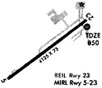
| Runways: | 05/23 |
| Longest Runway: | 05/23 is 4126 ft (1258 m) long |
| Runways with an Instrument Approach: |
5G7 Airport Runway Details
| Runway 05/23 | 4126 ft x 75 ft (1258 m x 23 m) | |
| Runway Length Source: | 3RD PARTY SURVEY as of 12/05/2017 | |
| Surface: | Asphalt - Good condition - No special surface treatment | |
| Runway Edge Lights: | Medium Intensity | |
Runway Weight Bearing Capacity (in thousands of pounds) |
||
| Single Wheel Landing Gear: | 12.5 | |
Runway 05 |
Runway 23 |
|
Elevation: |
850.6 | 846.7 |
Latitude: |
40-52-54.9640N | 40-53-20.2083N |
Longitude: |
083-52-28.1881W | 083-51-46.0181W |
|
Runway True Alignment: |
052 | 232 |
Glide Path Angle: |
0.0 degrees | 3.0 degrees |
Traffic Pattern: |
Left | Left |
Runway Markings Type: |
Nonprecision Instrument | Nonprecision Instrument |
Runway Markings Condition: |
Good | Good |
Object at End: |
TREES | CROPS |
Object Height: |
52 | 8 |
Distance from End: |
634 | 201 |
Object Centerline Offset: |
130 ft. left of centerline | 160 ft. left of centerline |
Visual Glide Slope Indicators: |
4-Light PAPI On Left Side Of Runway | |
REIL: |
Yes | Yes |
Touchdown Lights: |
No | No |
Centerline Lights: |
No | No |
Threshold Crossing Height: |
43 |
Services
Airframe Repair: |
Minor |
Powerplant Repair: |
Minor |
Bottled Oxygen: |
None |
Bulk Oxygen: |
None |
Fuel Available: |
100LL, Jet A-1+ |
Landing Fees: |
No |
Parking: |
Hangars and tiedowns available |
Maps & Diagrams
5G7 Sectional
Flight Planning
at skyvector.com
at skyvector.com