Location
Latitude: |
41-13-26.1950N (41.223943) |
Longitude: |
082-57-27.6860W (-82.957691) |
Elevation: |
805.0 feet MSL (245 m MSL) |
Magnetic Variation: |
7.4 W (as of April 2024 from WMM2020 model) |
Time Zone: |
UTC -5.0 (Standard Time) UTC -4.0 (Daylight Savings Time) |
From City: |
05 N.M. S of Clyde, Ohio |
Found On: |
Detroit Chart |
FAA Region: |
AGL |
Contacts
Manager: |
Privately owned: |
| MICHAEL MATESICK 6610 TOWNSHIP ROAD 78 GREEN SPRINGS, OH 44836 419-483-3607 |
MICHAEL MATESICK 6606 TOWNSHIP ROAD 78 GREEN SPRINGS, OH 44836-9714 419-483-3607 |
Operations
Airport Status: |
Operational |
Facility Use: |
Public |
Type: |
Airport |
Activation Date: |
01/1973 |
Control tower: |
No |
Attendance (Months/Days/Hours): |
Months/Days/Hours ALL/ALL/IREG |
Boundary ARTCC: |
ZOB (Cleveland) |
Responsible ARTCC: |
ZOB (Cleveland) |
Segmented Circle Indicator: |
No |
Traffic Pattern Altitude (MSL): |
1805 feet (550 m) |
NOTAMs Facility: |
CLE |
NOTAM-D Service: |
Yes |
Based Aircraft
| Single Engine: | 2 |
Annual Operations (as of 09/29/2021)
| Total Operations: | 100 | |
| GA Itinerant: | 100 | 100.0% |
Communications
| CTAF: | 122.900 |
Fixed Based Operators (FBOs) & Fuel
(Click on a business for detail)
Please help us keep this information up to date. This is a FREE SERVICE just like everything else on Airport Guide! If you see that a business needs to be added, modified, or deleted please fill out our Update Form.
To add, modify, or delete a business click here.
Please help us keep this information up to date. This is a FREE SERVICE just like everything else on Airport Guide! If you see that a business needs to be added, modified, or deleted please fill out our Update Form.
Area Code: 419 |
| Business Name | Frequency | Phone | Fuel Grade |
|---|
Flight Service Stations
| Primary | Alternate | |
| FSS on Field: | N | |
| FSS Name (ID): | Cleveland(CLE) | |
| Frequency: | ||
| Toll Free Phone: | 1-800-WX-BRIEF |
Instrument Procedures / Charts
Terminal Procedures are only available for airports in several countries with more being added all the time. If you are looking for a specific country's charts, please send an email to support(at)airportguide.com stating the country name. This will be used to prioritize the implementation.
Navigation Aids (Navaids) near 5D9
| Dist (NM) | ID | Morse Code | Name | Type | Freq | True Hdg | Mag Hdg |
|---|---|---|---|---|---|---|---|
| 14.0 | TII | _ . . . . | Tiffin | NDB | 269 | 236 | 243 |
| 18.1 | PCW | . _ _ . _ . _ . . _ _ | Port Clinton | NDB | 423 | 12 | 20 |
| 18.6 | SKY | . . . _ . _ _ . _ _ | Sandusky | VOR-DME | 109.20 | 47 | 55 |
| 19.9 | FZI | . . _ . _ _ . . . . | Fostoria | NDB | 379 | 264 | 271 |
| 27.0 | MFD | _ _ . . _ . _ . . | Mansfield | VORTAC | 108.80 | 141 | 149 |
| 33.6 | VWV | . . . _ . _ _ . . . _ | Waterville | VOR-DME | 113.10 | 294 | 301 |
| 34.4 | BNR | _ . . . _ . . _ . | Benton Ridge | NDB | 334 | 249 | 256 |
| 35.5 | AAU | . _ . _ . . _ | Ashland | NDB | 329 | 115 | 123 |
| 36.0 | MF | _ _ . . _ . | Manns | NDB | 372 | 139 | 147 |
| 36.8 | BUD | _ . . . . . _ _ . . | Buckeye | VOR | 109.80 | 187 | 194 |
| 36.8 | DJB | _ . . . _ _ _ _ . . . | Dryer | VOR-DME | 113.60 | 77 | 85 |
| 39.5 | FBC | . . _ . _ . . . _ . _ . | Flag City | VORTAC | 108.20 | 246 | 253 |
| 43.9 | TOL | _ _ _ _ . _ . . | Toledo | TACAN | 112.50 | 300 | 307 |
| 47.7 | TO | _ _ _ _ | Tophr | NDB | 219 | 294 | 301 |
| 51.3 | CLE | _ . _ . . _ . . . | Cleveland | VOT | 110.40 | 76 | 84 |
| 53.4 | RYS | . _ . _ . _ _ . . . | Grosse Ile | NDB | 419 | 350 | 357 |
| 54.3 | CRL | _ . _ . . _ . . _ . . | Carleton | VOR-DME | 115.70 | 335 | 342 |
| 55.3 | AOH | . _ _ _ _ . . . . | Allen County | VOR | 108.40 | 236 | 243 |
| 56.1 | RUV | . _ . . . _ . . . _ | Rushsylvania | NDB | 326 | 215 | 222 |
| 57.7 | USE | . . _ . . . . | Fulton | NDB | 375 | 293 | 300 |
Nearby Airports with Fuel
Notices to Airmen (NOTAMS)
Remarks
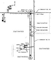
| A110-1 | PVT RD CROSSES RWY 18/36 550 FT N OF THE AER RWY 36 |
| A110-2 | OCCL DEER, BIRDS & OTHER WILDLIFE ON & INVOF ARPT |
| A110-3 | FOR CD CTC CLEVELAND APCH AT 216-352-2323, WHEN APCH CLSD CTC CLEVELAND ARTCC AT 440-774-0222. |
| A42-18 | RWY ENDS & DTHR MKD WITH RED/YELLOW CHECKERBOARD PANELS. |
| A42-36 | RWY ENDS MKD WITH RED/YELLOW CHECKERBOARD PANELS. |
| A57-18 | +8 CROPS OBST CLNS SLOPE 0:1 TO DTHR. |
| A75 | TNST HNGR STORAGE ON AVAILABILITY, PRIOR CDN REQUIRED |
| A75 1 | TNST TIE-DOWN, PRIOR COORDINATION REQUIRED, USER SUPPLIED ROPES REQUIRED |
| E111 | PVT RD XING RWY 500'N OF AER 36 CREATING UNSAFE COND FOR ACFT USING RWY. |
Runways
Runway Summary
| Runways: | 18/36 |
| Longest Runway: | 18/36 is 2630 ft (802 m) long |
| Runways with an Instrument Approach: |
5D9 Airport Runway Details
| Runway 18/36 | 2630 ft x 80 ft (802 m x 24 m) | |
| Surface: | Turf - Fair condition - No special surface treatment | |
Runway 18 |
Runway 36 |
|
Elevation: |
805.0 | 805.0 |
Latitude: |
41-13-39.1800N | 41-13-13.2000N |
Longitude: |
082-57-27.5200W | 082-57-27.8300W |
|
Runway True Alignment: |
181 | 001 |
Glide Path Angle: |
0.0 degrees | 0.0 degrees |
Traffic Pattern: |
Left | Left |
Object at End: |
ROAD | CROPS |
Object Height: |
16 | 8 |
Distance from End: |
22 | 10 |
Object Centerline Offset: |
125 ft. left and right of centerline | 125 ft. left and right of centerline |
REIL: |
No | No |
Touchdown Lights: |
No | No |
Centerline Lights: |
No | No |
Displaced Threshold: |
255 | |
Threshold Latitude: |
41-13-36.6606N | |
Threshold Longitude: |
082-57-27.5501W |
Services
Airframe Repair: |
Major |
Powerplant Repair: |
Major |
Bottled Oxygen: |
None |
Bulk Oxygen: |
None |
Fuel Available: |
100LL, Jet A+ |
Landing Fees: |
No |
Parking: |
Hangars and tiedowns available |
Maps & Diagrams
5D9 Sectional
Flight Planning
at skyvector.com
at skyvector.com