Location
Latitude: |
43-07-39.1000N (43.127528) |
Longitude: |
121-48-31.4000W (-121.808722) |
Elevation: |
4638.0 feet MSL (1414 m MSL) |
Magnetic Variation: |
14.1 E (as of April 2024 from WMM2020 model) |
Time Zone: |
UTC -8.0 (Standard Time) UTC -7.0 (Daylight Savings Time) |
From City: |
01 N.M. SW of Beaver Marsh, Oregon |
Found On: |
Klamath Falls Chart |
FAA Region: |
ANM |
Contacts
Manager: |
Privately owned: |
| PAUL EHRHARDT 92790 SOVERN PLACE JUNCTION CITY, OR 97448 (541) 554-6143 |
GREGORY KACKSTETTER PO BOX 192 SAN LUIS REY, CA 92068 (559) 760-6698 |
Operations
Airport Status: |
Operational |
Facility Use: |
Public |
Type: |
Airport |
Activation Date: |
12/1944 |
Control tower: |
No |
Attendance (Months/Days/Hours): |
Months/Days/Hours Unattended |
Boundary ARTCC: |
ZSE (Seattle) |
Responsible ARTCC: |
ZSE (Seattle) |
Lighting Schedule: |
SS-SR |
Segmented Circle Indicator: |
No |
Traffic Pattern Altitude (MSL): |
5638 feet (1718 m) |
NOTAMs Facility: |
MMV |
NOTAM-D Service: |
Yes |
International Airport of Entry: |
No |
Customs Landing Rights: |
No |
Civil/Military Joint Use: |
No |
Based Aircraft
Annual Operations (as of 11/18/2019)
| Total Operations: | 150 | |
| GA Itinerant: | 150 | 100.0% |
Communications
| CTAF: | 122.900 |
Fixed Based Operators (FBOs) & Fuel
(Click on a business for detail)
Please help us keep this information up to date. This is a FREE SERVICE just like everything else on Airport Guide! If you see that a business needs to be added, modified, or deleted please fill out our Update Form.
To add, modify, or delete a business click here.
Please help us keep this information up to date. This is a FREE SERVICE just like everything else on Airport Guide! If you see that a business needs to be added, modified, or deleted please fill out our Update Form.
Area Code: 503 |
| Business Name | Frequency | Phone | Fuel Grade |
|---|
Flight Service Stations
| Primary | Alternate | |
| FSS on Field: | N | |
| FSS Name (ID): | Mc Minnville(MMV) | |
| Frequency: | ||
| Toll Free Phone: | 1-800-WX-BRIEF |
Instrument Procedures / Charts
Terminal Procedures are only available for airports in several countries with more being added all the time. If you are looking for a specific country's charts, please send an email to support(at)airportguide.com stating the country name. This will be used to prioritize the implementation.
Navigation Aids (Navaids) near 2S2
| Dist (NM) | ID | Morse Code | Name | Type | Freq | True Hdg | Mag Hdg |
|---|---|---|---|---|---|---|---|
| 58.6 | LMT | . _ . . _ _ _ | Klamath Falls | VORTAC | 115.90 | 176 | 162 |
| 62.2 | OED | _ _ _ . _ . . | Rogue Valley | VORTAC | 113.60 | 231 | 217 |
| 64.6 | MEF | _ _ . . . _ . | Medford | NDB | 356 | 227 | 213 |
| 65.6 | MFR | _ _ . . _ . . _ . | Medford | VOT | 117.20 | 225 | 211 |
| 67.6 | RBG | . _ . _ . . . _ _ . | Roseburg | VOR-DME | 108.20 | 273 | 259 |
| 68.1 | RBG | . _ . _ . . . _ _ . | Roseburg | NDB | 400 | 275 | 261 |
| 68.8 | LKV | . _ . . _ . _ . . . _ | Lakeview | VORTAC | 112.00 | 123 | 109 |
| 71.0 | DSD | _ . . . . . _ . . | Deschutes | VORTAC | 117.60 | 17 | 3 |
| 78.7 | RD | . _ . _ . . | Bodey | NDB | 411 | 25 | 11 |
| 85.6 | EUG | . . . _ _ _ . | Eugene | VORTAC | 112.90 | 314 | 300 |
| 89.1 | MOG | _ _ _ _ _ _ _ . | Montague | NDB | 404 | 199 | 185 |
| 89.4 | EU | . . . _ | Frakk | NDB | 260 | 317 | 303 |
Nearby Airports with Fuel
Notices to Airmen (NOTAMS)
Remarks
| A110-1 | CLSD WINTER MONTHS EXCEPT TO SKI EQUIPPED ACFT. |
| A110-2 | 10 FT-20 FT TREES WITHIN 50 FT OF EAST EDGE OF RY. |
| A110-3 | FOR CD CTC SEATTLE ARTCC AT 253-351-3694. |
| A32-18/36 | 25 FT RY WIDTH USBL IN CENTER. |
| A33-18/36 | 1-2 FT TREES AND SHRUBS |
| A33-18/36 1 | RY 18/36 DIRT SFC LOOSE & POWDERY, CREATES CLOUDS OF DUST; LOOSE 2-5' ROCKS ON SFC, ROUGH. NUMEROUS PATCHES OF 1 FT BRUSH ON RY. |
| E111 | ESTABLISHED PRIOR TO 1959. |
Runways
Runway Summary
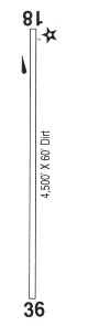
| Runways: | 18/36 |
| Longest Runway: | 18/36 is 4500 ft (1372 m) long |
| Runways with an Instrument Approach: |
2S2 Airport Runway Details
| Runway 18/36 | 4500 ft x 60 ft (1372 m x 18 m) | |
| Surface: | Dirt - Poor condition - No special surface treatment | |
| Runway Edge Lights: | Low Intensity | |
Runway 18 |
Runway 36 |
|
Elevation: |
4632.0 | 4626.0 |
Latitude: |
43-08-00.3476N | 43-07-17.8966N |
Longitude: |
121-48-22.3760W | 121-48-40.4053W |
|
Runway True Alignment: |
197 | 017 |
Glide Path Angle: |
0.0 degrees | 0.0 degrees |
Traffic Pattern: |
Left | Left |
Object at End: |
TREES | TREES |
Object Height: |
35 | 25 |
Distance from End: |
225 | 375 |
Object Centerline Offset: |
50 ft. right of centerline | 0 ft. left and right of centerline |
Services
Airframe Repair: |
Major |
Powerplant Repair: |
Major |
Bottled Oxygen: |
None |
Bulk Oxygen: |
None |
Fuel Available: |
100LL, MOGAS |
Landing Fees: |
No |
Parking: |
Tiedowns available |
Maps & Diagrams
2S2 Sectional
Flight Planning
at skyvector.com
at skyvector.com