Location
Latitude: |
37-22-51.3000N (37.380917) |
Longitude: |
096-16-16.0000W (-96.271111) |
Elevation: |
1063.0 feet MSL (324 m MSL) |
Magnetic Variation: |
2.4 E (as of April 2024 from WMM2020 model) |
Time Zone: |
UTC -6.0 (Standard Time) UTC -5.0 (Daylight Savings Time) |
From City: |
03 N.M. NE of Moline, Kansas |
Found On: |
Kansas City Chart |
FAA Region: |
ACE |
Contacts
Manager: |
Publicly owned: |
| BETH KOEHLER POST OFFICE BOX 623 HOWARD, KS 67349 620-374-3597 |
ELK COUNTY COURTHOUSE HOWARD, KS 67349 620-374-2490 |
Operations
Airport Status: |
Operational |
Facility Use: |
Public |
Type: |
Airport |
Activation Date: |
12/1946 |
Control tower: |
No |
Attendance (Months/Days/Hours): |
Months/Days/Hours Unattended |
Boundary ARTCC: |
ZKC (Kansas City) |
Responsible ARTCC: |
ZKC (Kansas City) |
Segmented Circle Indicator: |
No |
Traffic Pattern Altitude (MSL): |
2063 feet (629 m) |
NOTAMs Facility: |
ICT |
NOTAM-D Service: |
Yes |
Based Aircraft
| Single Engine: | 2 |
Annual Operations (as of 08/19/2020)
| Total Operations: | 10 | |
| GA Local: | 10 | 100.0% |
Communications
| CTAF: | 122.900 |
Fixed Based Operators (FBOs) & Fuel
(Click on a business for detail)
Please help us keep this information up to date. This is a FREE SERVICE just like everything else on Airport Guide! If you see that a business needs to be added, modified, or deleted please fill out our Update Form.
To add, modify, or delete a business click here.
Please help us keep this information up to date. This is a FREE SERVICE just like everything else on Airport Guide! If you see that a business needs to be added, modified, or deleted please fill out our Update Form.
Area Code: 620 |
| Business Name | Frequency | Phone | Fuel Grade |
|---|
Flight Service Stations
| Primary | Alternate | |
| FSS on Field: | N | |
| FSS Name (ID): | Wichita(ICT) | |
| Frequency: | ||
| Toll Free Phone: | 1-800-WX-BRIEF |
Instrument Procedures / Charts
Terminal Procedures are only available for airports in several countries with more being added all the time. If you are looking for a specific country's charts, please send an email to support(at)airportguide.com stating the country name. This will be used to prioritize the implementation.
Navigation Aids (Navaids) near 2K6
| Dist (NM) | ID | Morse Code | Name | Type | Freq | True Hdg | Mag Hdg |
|---|---|---|---|---|---|---|---|
| 34.7 | BV | _ . . . . . . _ | Dewie | NDB | 201 | 159 | 157 |
| 35.0 | BVO | _ . . . . . . _ _ _ _ | Bartlesville | VOR-DME | 117.90 | 159 | 157 |
| 35.5 | CNU | _ . _ . _ . . . _ | Chanute | VOR-DME | 109.20 | 65 | 63 |
| 37.6 | CFV | _ . _ . . . _ . . . . _ | Coffeyville | NDB | 212 | 117 | 115 |
| 40.5 | SO | . . . _ _ _ | Sawcy | NDB | 353 | 244 | 241 |
| 47.6 | MSB | _ _ . . . _ . . . | Monarch | NDB | 410 | 58 | 56 |
| 49.6 | IAB | . . . _ _ . . . | Mc Connell | TACAN | 116.50 | 287 | 284 |
| 51.8 | PN | . _ _ . _ . | Ponca | NDB | 515 | 230 | 227 |
| 52.7 | OSW | _ _ _ . . . . _ _ | Oswego | DME | 117.6 | 104 | 102 |
| 53.5 | EGT | . _ _ . _ | Wellington | NDB | 414 | 266 | 263 |
| 55.0 | EMP | . _ _ . _ _ . | Emporia | VORTAC | 112.80 | 6 | 4 |
| 57.1 | PER | . _ _ . . . _ . | Pioneer | VORTAC | 113.20 | 228 | 225 |
| 57.4 | ICT | . . _ . _ . _ | Wichita | VOT | 114.00 | 285 | 282 |
| 57.6 | IC | . . _ . _ . | Piche | NDB | 332 | 282 | 279 |
| 61.0 | UKL | . . _ _ . _ . _ . . | Boyd | NDB | 245 | 25 | 23 |
| 62.8 | EWK | . . _ _ _ . _ | Newton | NDB | 281 | 311 | 308 |
| 66.1 | CA | _ . _ . . _ | Harvs | NDB | 395 | 314 | 311 |
| 66.1 | ICT | . . _ . _ . _ | Wichita | VORTAC | 113.80 | 289 | 286 |
| 72.7 | OWP | _ _ _ . _ _ . _ _ . | William Pogue | NDB | 362 | 175 | 173 |
| 73.3 | TUL | _ . . _ . _ . . | Tulsa Intl | VOT | 109.00 | 165 | 163 |
Nearby Airports with Fuel
Notices to Airmen (NOTAMS)
Remarks
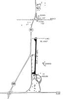
| A110-1 | WILDLIFE ON & INVOF ARPT. |
| A110-2 | FOR CD CTC KANSAS CITY ARTCC AT 913-254-8508. |
| A30-18/36 | RWY 18/36 HAS CENTERLINE MARKING ONLY |
| A53-36 | THE POLES THAT CONSTITUTE THE CONTROLLING OBSTRUCTION ON THE RIGHT ARE NOT VISIBLY MARKED OR LGTD. |
| A58-18 | OVERGROWN GRASS WATERWAY 20 FT FM RY END. SMALL TREE 25 FT TALL, 115 FT RIGHT OF RWY. |
| A58-36 | +15 FT ROAD AT THLD. |
Runways
Runway Summary
| Runways: | 18/36 |
| Longest Runway: | 18/36 is 2510 ft (765 m) long |
| Runways with an Instrument Approach: |
2K6 Airport Runway Details
| Runway 18/36 | 2510 ft x 40 ft (765 m x 12 m) | |
| Surface: | Asphalt - Good condition - No special surface treatment | |
Runway 18 |
Runway 36 |
|
Elevation: |
1063.0 | 1053.0 |
Latitude: |
37-23-03.7353N | 37-22-38.9494N |
Longitude: |
096-16-15.1151W | 096-16-16.7955W |
|
Runway True Alignment: |
183 | 003 |
Glide Path Angle: |
0.0 degrees | 0.0 degrees |
Traffic Pattern: |
Left | Left |
Runway Markings Type: |
Nonstandard (other than numbers only) | Nonstandard (other than numbers only) |
Runway Markings Condition: |
Fair | Fair |
Object at End: |
POLE | |
Object Height: |
38 | |
Distance from End: |
289 | |
Object Centerline Offset: |
119 ft. right of centerline |
Services
Airframe Repair: |
Major |
Powerplant Repair: |
Major |
Bottled Oxygen: |
None |
Bulk Oxygen: |
Low Pressure |
Fuel Available: |
100LL, Jet A |
Landing Fees: |
No |
Parking: |
Hangars and tiedowns available |
Maps & Diagrams
2K6 Sectional
Flight Planning
at skyvector.com
at skyvector.com