Location
Latitude: |
36-57-44.3000N (36.962306) |
Longitude: |
093-41-43.2000W (-93.695333) |
Elevation: |
1433.6 feet MSL (437 m MSL) |
Magnetic Variation: |
0.6 E (as of April 2024 from WMM2020 model) |
Time Zone: |
UTC -6.0 (Standard Time) UTC -5.0 (Daylight Savings Time) |
From City: |
02 N.M. SE of Aurora, Missouri |
Found On: |
Kansas City Chart |
FAA Region: |
ACE |
Contacts
Manager: |
Publicly owned: |
| JUSTIN RICHMOND 1525 E. HIGHLAND AURORA, MO 65605 417-235-4118 |
CITY OF AURORA PO BOX 30 AURORA, MO 65605 417-678-5121 |
Operations
Airport Status: |
Operational |
Facility Use: |
Public |
Type: |
Airport |
Activation Date: |
03/1958 |
Control tower: |
No |
Attendance (Months/Days/Hours): |
Months/Days/Hours Unattended |
Boundary ARTCC: |
ZKC (Kansas City) |
Responsible ARTCC: |
ZKC (Kansas City) |
Lighting Schedule: |
SEE RMK |
Segmented Circle Indicator: |
Yes |
Traffic Pattern Altitude (MSL): |
2434 feet (742 m) |
NOTAMs Facility: |
COU |
NOTAM-D Service: |
Yes |
International Airport of Entry: |
No |
Customs Landing Rights: |
No |
Military Landing Rights: |
Yes |
Civil/Military Joint Use: |
No |
Based Aircraft
| Single Engine: | 14 |
Annual Operations (as of 12/31/2019)
| Total Operations: | 10875 | |
| Air Taxi: | 75 | 0.7% |
| GA Local: | 7900 | 72.6% |
| GA Itinerant: | 2600 | 23.9% |
| Military Aircraft: | 300 | 2.8% |
Communications
| CTAF: | 122.800 |
| Unicom: | 122.800 |
| Approach: | SPRINGFIELD 124.95 124.95 |
| Departure: | SPRINGFIELD 124.95 124.95 |
Fixed Based Operators (FBOs) & Fuel
(Click on a business for detail)
Please help us keep this information up to date. This is a FREE SERVICE just like everything else on Airport Guide! If you see that a business needs to be added, modified, or deleted please fill out our Update Form.
To add, modify, or delete a business click here.
Please help us keep this information up to date. This is a FREE SERVICE just like everything else on Airport Guide! If you see that a business needs to be added, modified, or deleted please fill out our Update Form.
Area Code: 417 |
| Business Name | Frequency | Phone | Fuel Grade |
|---|---|---|---|
| Aurora Aviation
Update FBO info |
Unicom 122.8 | 678-3000 | 100LL, MOGAS |
Flight Service Stations
| Primary | Alternate | |
| FSS on Field: | N | |
| FSS Name (ID): | Columbia(COU) | |
| Frequency: | ||
| Toll Free Phone: | 1-800-WX-BRIEF |
Instrument Procedures / Charts
FAA Terminal Procedures valid from 0901Z 03/21/24 to 0901Z 04/18/24.
There are various types of charts available for an airport. They are listed in the Page Type column. Here is a legend for those types:
APD - Airport Diagram
DP - Departure Procedure Charts
HOT - Hot Spots
IAP - Instrument Approach Procedure Charts
MIN - Minimums
STAR - Standard Terminal Arrival Charts
| Page Type | Page Name | Volume | Action Since Last Cycle |
|---|---|---|---|
| IAP | RNAV (GPS) RWY 18 | NC-3 | |
| IAP | RNAV (GPS) RWY 36 | NC-3 | |
| MIN | TAKEOFF MINIMUMS | NC-3 |
Terminal Procedures are only available for airports in several countries with more being added all the time. If you are looking for a specific country's charts, please send an email to support(at)airportguide.com stating the country name. This will be used to prioritize the implementation.
Navigation Aids (Navaids) near 2H2
| Dist (NM) | ID | Morse Code | Name | Type | Freq | True Hdg | Mag Hdg |
|---|---|---|---|---|---|---|---|
| 29.3 | SGF | . . . _ _ . . . _ . | Springfield | VORTAC | 116.90 | 36 | 36 |
| 35.0 | RO | . _ . _ _ _ | Rogrs | NDB | 263 | 211 | 210 |
| 36.2 | EOS | . _ _ _ . . . | Neosho | DME | 117.3 | 258 | 257 |
| 39.4 | DGD | _ . . _ _ . _ . . | Dogwood | VORTAC | 109.40 | 84 | 84 |
| 43.1 | LLU | . _ . . . _ . . . . _ | Spring River | NDB | 356 | 317 | 316 |
| 43.8 | JL | . _ _ _ . _ . . | Lunns | NDB | 344 | 289 | 288 |
| 45.1 | HRO | . . . . . _ . _ _ _ | Harrison | VOR-DME | 112.50 | 148 | 148 |
| 47.6 | RZC | . _ . _ _ . . _ . _ . | Razorback | VORTAC | 116.40 | 205 | 204 |
| 53.0 | HR | . . . . . _ . | Bakky | NDB | 395 | 150 | 150 |
| 57.1 | PTS | . _ _ . _ . . . | Pittsburg | NDB | 365 | 300 | 299 |
| 60.1 | SLG | . . . . _ . . _ _ . | Siloam Springs | NDB | 284 | 219 | 218 |
| 60.2 | DAK | _ . . . _ _ . _ | Drake | DME | 115.25 | 203 | 202 |
| 61.6 | IEB | . . . _ . . . | Lebanon | NDB | 414 | 53 | 53 |
| 71.5 | FSK | . . _ . . . . _ . _ | Fort Scott | NDB | 379 | 314 | 313 |
| 71.6 | FLP | . . _ . . _ . . . _ _ . | Flippin | DME | 116.05 | 123 | 123 |
| 73.2 | OSW | _ _ _ . . . . _ _ | Oswego | DME | 117.6 | 279 | 278 |
| 83.0 | SHY | . . . . . . . _ . _ _ | Sunshine | VOR-DME | 108.40 | 38 | 38 |
| 83.8 | GLY | _ _ . . _ . . _ . _ _ | Golden Valley | NDB | 388 | 0 | 359 |
| 86.2 | UNO | . . _ _ . _ _ _ | Pomona | NDB | 335 | 92 | 92 |
| 86.3 | HUW | . . . . . . _ . _ _ | Hutton | DME | 111.6 | 93 | 93 |
Nearby Airports with Fuel
Notices to Airmen (NOTAMS)
Remarks
| A110-1 | MECHANIC ON DUTY; MON THRU SAT; MAJOR POWERPLANT REPAIR AVBL CALL 417-678-3000. |
| A110-2 | FOR CD CTC SPRINGFIELD APCH AT 417-868-5620/5619. |
| A81-APT | ACTVT MIRL RWY 18/36 - CTAF. |
Runways
Runway Summary
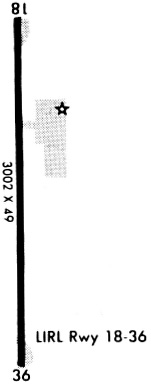
| Runways: | 18/36 |
| Longest Runway: | 18/36 is 3001 ft (915 m) long |
| Runways with an Instrument Approach: |
2H2 Airport Runway Details
| Runway 18/36 | 3001 ft x 60 ft (915 m x 18 m) | |
| Runway Length Source: | 3RD PARTY SURVEY as of 03/26/2014 | |
| Surface: | Asphalt - Good condition - No special surface treatment | |
| Runway Edge Lights: | Medium Intensity | |
Runway 18 |
Runway 36 |
|
Elevation: |
1433.1 | 1424.0 |
Latitude: |
36-57-59.1010N | 36-57-29.4364N |
Longitude: |
093-41-42.7485W | 093-41-43.5531W |
|
Runway True Alignment: |
181 | 001 |
Glide Path Angle: |
0.0 degrees | 0.0 degrees |
Traffic Pattern: |
Right | |
Runway Markings Type: |
Nonprecision Instrument | Nonprecision Instrument |
Runway Markings Condition: |
Good | Good |
Object at End: |
ROAD | |
Object Height: |
18 | |
Distance from End: |
420 | |
Object Centerline Offset: |
290 ft. left and right of centerline |
Services
Airframe Repair: |
Minor |
Powerplant Repair: |
Minor |
Bulk Oxygen: |
None |
Fuel Available: |
100LL, Jet A |
Landing Fees: |
No |
Parking: |
Tiedowns available |
Maps & Diagrams
2H2 Sectional
Flight Planning
at skyvector.com
at skyvector.com