Location
Latitude: |
40-21-38.2000N (40.360611) |
Longitude: |
080-42-06.1000W (-80.701694) |
Elevation: |
1198.0 feet MSL (365 m MSL) |
Magnetic Variation: |
8.8 W (as of April 2024 from WMM2020 model) |
Time Zone: |
UTC -5.0 (Standard Time) UTC -4.0 (Daylight Savings Time) |
From City: |
04 N.M. W of Steubenville, Ohio |
Found On: |
Detroit Chart |
FAA Region: |
AGL |
Contacts
Manager: |
Publicly owned: |
| BRIAN THAXTON 600 AIRPARK DR WINTERSVILLE, OH 43953-9237 740-264-5388 |
JEFFERSON CO COMMISSIONERS PO BOX 383 STEUBENVILLE, OH 43952-5383 740-283-8500 |
Operations
Airport Status: |
Operational |
Facility Use: |
Public |
Type: |
Airport |
Activation Date: |
01/1948 |
Control tower: |
No |
Attendance (Months/Days/Hours): |
Months/Days/Hours ALL/ALL/0900-1700 |
Boundary ARTCC: |
ZOB (Cleveland) |
Responsible ARTCC: |
ZOB (Cleveland) |
Lighting Schedule: |
SEE RMK |
Segmented Circle Indicator: |
Yes |
Traffic Pattern Altitude (MSL): |
2198 feet (670 m) |
NOTAMs Facility: |
2G2 |
NOTAM-D Service: |
Yes |
International Airport of Entry: |
No |
Customs Landing Rights: |
No |
Military Landing Rights: |
No |
Civil/Military Joint Use: |
No |
Based Aircraft
| Single Engine: | 31 |
| Multi Engine: | 1 |
| Jet Engine: | 1 |
| GA Helicopters: | 1 |
Annual Operations (as of 09/27/2022)
| Total Operations: | 10425 | |
| Air Taxi: | 246 | 2.4% |
| GA Local: | 9573 | 91.8% |
| GA Itinerant: | 456 | 4.4% |
| Military Aircraft: | 150 | 1.4% |
Communications
| CTAF: | 122.800 |
| Unicom: | 122.800 |
| Approach: | PITTSBURGH 124.75 124.75 124.75 124.75 |
| Departure: | PITTSBURGH 124.75 124.75 124.75 124.75 |
| AWOS-3: | 121.625 (740-275-4862) |
Fixed Based Operators (FBOs) & Fuel
(Click on a business for detail)
Please help us keep this information up to date. This is a FREE SERVICE just like everything else on Airport Guide! If you see that a business needs to be added, modified, or deleted please fill out our Update Form.
To add, modify, or delete a business click here.
Please help us keep this information up to date. This is a FREE SERVICE just like everything else on Airport Guide! If you see that a business needs to be added, modified, or deleted please fill out our Update Form.
Area Code: 740 |
| Business Name | Frequency | Phone | Fuel Grade |
|---|---|---|---|
| Jefferson County Airpark
Update FBO info |
Unicom 122.8 | 264-5388 | 80, 100LL |
Flight Service Stations
| Primary | Alternate | |
| FSS on Field: | N | |
| FSS Name (ID): | Cleveland(CLE) | |
| Frequency: | ||
| Toll Free Phone: | 1-800-WX-BRIEF |
Instrument Procedures / Charts
FAA Terminal Procedures valid from 0901Z 03/21/24 to 0901Z 04/18/24.
There are various types of charts available for an airport. They are listed in the Page Type column. Here is a legend for those types:
APD - Airport Diagram
DP - Departure Procedure Charts
HOT - Hot Spots
IAP - Instrument Approach Procedure Charts
MIN - Minimums
STAR - Standard Terminal Arrival Charts
| Page Type | Page Name | Volume | Action Since Last Cycle |
|---|---|---|---|
| IAP | RNAV (GPS) RWY 14 | EC-2 | |
| IAP | RNAV (GPS) RWY 32 | EC-2 | |
| MIN | ALTERNATE MINIMUMS | EC-2 | |
| MIN | TAKEOFF MINIMUMS | EC-2 |
Terminal Procedures are only available for airports in several countries with more being added all the time. If you are looking for a specific country's charts, please send an email to support(at)airportguide.com stating the country name. This will be used to prioritize the implementation.
Navigation Aids (Navaids) near 2G2
| Dist (NM) | ID | Morse Code | Name | Type | Freq | True Hdg | Mag Hdg |
|---|---|---|---|---|---|---|---|
| 8.6 | HLG | . . . . . _ . . _ _ . | Wheeling | VOR-DME | 114.25 | 134 | 143 |
| 16.1 | CFX | _ . _ . . . _ . _ . . _ | Cadiz | NDB | 239 | 242 | 251 |
| 21.3 | AIR | . _ . . . _ . | Bellaire | VOR-DME | 117.10 | 194 | 203 |
| 24.4 | MMJ | _ _ _ _ . _ _ _ | Montour | DME | 112 | 71 | 80 |
| 30.6 | AGC | . _ _ _ . _ . _ . | Allegheny | VOR-DME | 110.00 | 99 | 108 |
| 35.7 | EWC | . . _ _ _ . _ . | Ellwood City | VOR-DME | 115.80 | 38 | 47 |
| 36.3 | CTW | _ . _ . _ . _ _ | Newcomerstown | DME | 111.8 | 257 | 266 |
| 40.4 | BSV | _ . . . . . . . . . _ | Briggs | VOR-DME | 112.40 | 304 | 313 |
| 41.8 | UCP | . . _ _ . _ . . _ _ . | Castle | NDB | 272 | 18 | 27 |
| 42.1 | MKP | _ _ _ . _ . _ _ . | Mc Keesport | NDB | 287 | 90 | 99 |
| 47.4 | CAK | _ . _ . . _ _ . _ | Akron/Canton Regional | VOT | 110.60 | 314 | 323 |
| 48.2 | HBD | . . . . _ . . . _ . . | Hubbard | NDB | 408 | 9 | 18 |
| 50.3 | ACO | . _ _ . _ . _ _ _ | Akron | VOR-DME | 114.40 | 333 | 342 |
| 50.6 | YN | _ . _ _ _ . | Fetch | NDB | 338 | 5 | 14 |
| 52.4 | VV | . . . _ . . . _ | Camor | NDB | 299 | 122 | 131 |
| 52.7 | AK | . _ _ . _ | Akron | NDB | 362 | 323 | 332 |
| 54.6 | MLR | _ _ . _ . . . _ . | Millersburg/Dcmsnd | NDB | 382 | 281 | 289 |
| 58.2 | YNG | _ . _ _ _ . _ _ . | Youngstown | VORTAC | 109.00 | 1 | 10 |
| 60.1 | ZZV | _ _ . . _ _ . . . . . _ | Zanesville | VOR-DME | 114.95 | 245 | 253 |
| 61.8 | MGW | _ _ _ _ . . _ _ | Morgantown | VOR-DME | 111.60 | 140 | 149 |
Nearby Airports with Fuel
Notices to Airmen (NOTAMS)
Remarks
| A110-1 | OCNL DEER, BIRDS, & OTR WILDLIFE ON & INVOF ARPT. |
| A110-2 | FOR CD CTC PITTSBURGH APCH AT 412-472-5591. |
| A17 | UNATNDD MAJOR HOLS. |
| A42-14 | MKGS FADED. |
| A70-FUEL-10 | 0LL AVBL 24 HRS WITH CREDIT CARD. |
| A70-FUEL-A | AVBL 24 HRS WITH CREDIT CARD. |
| A75 | PPR FOR TSNT HNGR STORAGE. |
| A81-APT | ACTVT REIL RWY 14 & 32; MIRL RWY 14/32 - CTAF. PAPI RWY 32 OPR CONSLY. |
| E111 | ESTABD BFR 1959. |
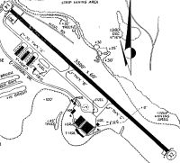
Runways
Runway Summary
| Runways: | 14/32 |
| Longest Runway: | 14/32 is 5001 ft (1524 m) long |
| Runways with an Instrument Approach: |
2G2 Airport Runway Details
| Runway 14/32 | 5001 ft x 75 ft (1524 m x 23 m) | |
| Runway Length Source: | 3RD PARTY SURVEY as of 08/20/2013 | |
| Surface: | Asphalt - Fair condition - No special surface treatment | |
| Runway Pavement Class: | 12 /F/D/X/T | |
| Runway Edge Lights: | Medium Intensity | |
Runway Weight Bearing Capacity (in thousands of pounds) |
||
| Single Wheel Landing Gear: | 31.0 | |
| Dual Wheel Landing Gear: | 42.5 | |
Runway 14 |
Runway 32 |
|
Elevation: |
1198.0 | 1190.5 |
Latitude: |
40-21-55.4670N | 40-21-21.0205N |
Longitude: |
080-42-29.2651W | 080-41-42.9551W |
|
Runway True Alignment: |
134 | 314 |
Glide Path Angle: |
0.0 degrees | 3.6 degrees |
Traffic Pattern: |
Left | Left |
Runway Markings Type: |
Nonprecision Instrument | Nonprecision Instrument |
Runway Markings Condition: |
Poor | Fair |
Object at End: |
TREES | |
Object Height: |
70 | |
Distance from End: |
1514 | |
Object Centerline Offset: |
365 ft. left of centerline | |
Visual Glide Slope Indicators: |
4-Light PAPI On Left Side Of Runway | |
REIL: |
Yes | Yes |
Touchdown Lights: |
No | No |
Centerline Lights: |
No | No |
Threshold Crossing Height: |
41 |
Services
Airframe Repair: |
Major |
Powerplant Repair: |
Major |
Bottled Oxygen: |
None |
Bulk Oxygen: |
None |
Fuel Available: |
100LL, Jet A, Jet A+ |
Landing Fees: |
No |
Parking: |
Hangars and tiedowns available |
Maps & Diagrams
2G2 Sectional
Flight Planning
at skyvector.com
at skyvector.com