Location
Latitude: |
39-19-41.2500N (39.328125) |
Longitude: |
082-26-30.5580W (-82.441822) |
Elevation: |
958.0 feet MSL (292 m MSL) |
Magnetic Variation: |
7.5 W (as of April 2024 from WMM2020 model) |
Time Zone: |
UTC -5.0 (Standard Time) UTC -4.0 (Daylight Savings Time) |
From City: |
05 N.M. NE of Mc Arthur, Ohio |
Found On: |
Cincinnati Chart |
FAA Region: |
AGL |
Contacts
Manager: |
Publicly owned: |
| NICK RUPERT 66285 AIRPORT RD NEW PLYMOUTH, OH 45654-8927 740-357-0268 |
VINTON COUNTY 100 E MAIN ST MC ARTHUR, OH 45651-1267 740-357-0268 |
Operations
Airport Status: |
Operational |
Facility Use: |
Public |
Type: |
Airport |
Control tower: |
No |
Attendance (Months/Days/Hours): |
Months/Days/Hours ALL/ALL/IREG |
Boundary ARTCC: |
ZID (Indianapolis) |
Responsible ARTCC: |
ZID (Indianapolis) |
Lighting Schedule: |
SEE RMK |
Segmented Circle Indicator: |
No |
Traffic Pattern Altitude (MSL): |
1958 feet (597 m) |
NOTAMs Facility: |
DAY |
NOTAM-D Service: |
Yes |
Based Aircraft
| Single Engine: | 8 |
Annual Operations (as of 10/05/2021)
| Total Operations: | 5225 | |
| GA Local: | 2750 | 52.6% |
| GA Itinerant: | 2200 | 42.1% |
| Military Aircraft: | 275 | 5.3% |
Communications
| CTAF: | 122.800 |
| Unicom: | 122.800 |
Fixed Based Operators (FBOs) & Fuel
(Click on a business for detail)
Please help us keep this information up to date. This is a FREE SERVICE just like everything else on Airport Guide! If you see that a business needs to be added, modified, or deleted please fill out our Update Form.
To add, modify, or delete a business click here.
Please help us keep this information up to date. This is a FREE SERVICE just like everything else on Airport Guide! If you see that a business needs to be added, modified, or deleted please fill out our Update Form.
Area Code: 740 |
| Business Name | Frequency | Phone | Fuel Grade |
|---|
Flight Service Stations
| Primary | Alternate | |
| FSS on Field: | N | |
| FSS Name (ID): | Dayton(DAY) | |
| Frequency: | ||
| Toll Free Phone: | 1-800-WX-BRIEF |
Instrument Procedures / Charts
Terminal Procedures are only available for airports in several countries with more being added all the time. If you are looking for a specific country's charts, please send an email to support(at)airportguide.com stating the country name. This will be used to prioritize the implementation.
Navigation Aids (Navaids) near 22I
| Dist (NM) | ID | Morse Code | Name | Type | Freq | True Hdg | Mag Hdg |
|---|---|---|---|---|---|---|---|
| 13.0 | UNI | . . _ _ . . . | Athens | FAN MARKER | 118 | 126 | |
| 15.3 | UGS | . . _ _ _ . . . . | University | NDB | 250 | 106 | 114 |
| 24.7 | EOP | . _ _ _ . _ _ . | Waverly | NDB | 385 | 247 | 254 |
| 27.6 | XUB | _ . . _ . . _ _ . . . | Yellow Bud | VOR | 112.50 | 295 | 302 |
| 28.0 | RZT | . _ . _ _ . . _ | Ross County | NDB | 236 | 283 | 290 |
| 36.6 | DD | _ . . _ . . | Cobbs | NDB | 253 | 313 | 320 |
| 36.6 | LCK | . _ . . _ . _ . _ . _ | Rickenbacker | TACAN | 69X | 322 | 329 |
| 37.9 | LC | . _ . . _ . _ . | Pickl | NDB | 376 | 331 | 338 |
| 39.5 | HNN | . . . . _ . _ . | Henderson | DME | 115.9 | 150 | 158 |
| 41.9 | HEH | . . . . . . . . . | Newark | NDB | 524 | 358 | 366 |
| 42.0 | CM | _ . _ . _ _ | Sumie | NDB | 391 | 340 | 347 |
| 42.3 | HRA | . . . . . _ . . _ | Zanesville | NDB | 204 | 34 | 42 |
| 44.7 | PK | . _ _ . _ . _ | Versi | NDB | 388 | 95 | 103 |
| 44.7 | ZZV | _ _ . . _ _ . . . . . _ | Zanesville | VOR-DME | 114.95 | 34 | 42 |
| 44.9 | CMH | _ . _ . _ _ . . . . | Port Columbus | VOT | 111.00 | 333 | 340 |
| 46.0 | BU | _ . . . . . _ | Boutn | NDB | 230 | 310 | 317 |
| 46.9 | CSS | _ . _ . . . . . . . | Court House | NDB | 414 | 290 | 297 |
| 47.8 | PKB | . _ _ . _ . _ _ . . . | Marietta Ohio | FAN MARKER | 85 | 93 | |
| 47.9 | PZO | . _ _ . _ _ . . _ _ _ | Peebles | NDB | 329 | 239 | 246 |
| 48.1 | YRK | _ . _ _ . _ . _ . _ | York | VORTAC | 112.80 | 211 | 218 |
Nearby Airports with Fuel
Notices to Airmen (NOTAMS)
Remarks
| A110-1 | OCNL DEER & GEESE ON & INVOF ARPT. |
| A110-2 | FOR CD CTC INDIANAPOLIS ARTCC AT 317-247-2411. |
| A33-09/27 | WDSPR, OPN, & UNSEALED CRACKS WITH VEGETATION GROWTH. |
| A42-09 | FADED. |
| A42-09 1 | NSTD DUE TO CNTRLN. |
| A42-27 | FADED. |
| A42-27 1 | NSTD DUE TO CNTRLN & THR BAR. |
| A70-FUEL-10 | 0LL FOR FUEL CALL 740-357-0268. |
| A81-APT | ACTVT PAPI RWY 27; MIRL RWY 09/27 - 122.9. |
| E111 | VFR USE ONLY. |
Runways
Runway Summary
| Runways: | 09/27 |
| Longest Runway: | 09/27 is 3725 ft (1135 m) long |
| Runways with an Instrument Approach: |
22I Airport Runway Details
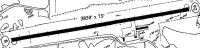
| Runway 09/27 | 3725 ft x 75 ft (1135 m x 23 m) | |
| Runway Length Source: | STATE as of 12/15/2006 | |
| Surface: | Asphalt - Poor condition - No special surface treatment | |
| Runway Edge Lights: | Medium Intensity | |
Runway 09 |
Runway 27 |
|
Elevation: |
956.0 | 958.0 |
Latitude: |
39-19-37.8458N | 39-19-44.8700N |
Longitude: |
082-26-53.0285W | 082-26-06.5000W |
Glide Path Angle: |
0.0 degrees | 4.0 degrees |
Traffic Pattern: |
Left | Left |
Runway Markings Type: |
Nonstandard (other than numbers only) | Nonstandard (other than numbers only) |
Runway Markings Condition: |
Poor | Poor |
Object at End: |
TREES | BRUSH |
Object Height: |
53 | 10 |
Distance from End: |
460 | 256 |
Object Centerline Offset: |
110 ft. right of centerline | 82 ft. right of centerline |
Visual Glide Slope Indicators: |
2-Light PAPI On Left Side Of Runway | |
REIL: |
No | No |
Touchdown Lights: |
No | No |
Centerline Lights: |
No | No |
Services
Airframe Repair: |
None |
Powerplant Repair: |
None |
Bottled Oxygen: |
None |
Bulk Oxygen: |
None |
Fuel Available: |
100LL, Jet A+ |
Landing Fees: |
No |
Parking: |
Hangars and tiedowns available |
Maps & Diagrams
22I Sectional
Flight Planning
at skyvector.com
at skyvector.com