Location
Latitude: |
43-27-58.5000N (43.46625) |
Longitude: |
115-18-36.1000W (-115.310028) |
Elevation: |
4232.0 feet MSL (1290 m MSL) |
Magnetic Variation: |
12.6 E (as of April 2024 from WMM2020 model) |
Time Zone: |
UTC -7.0 (Standard Time) UTC -6.0 (Daylight Savings Time) |
From City: |
01 N.M. S of Pine, Idaho |
Found On: |
Salt Lake City Chart |
FAA Region: |
ANM |
Contacts
Manager: |
Publicly owned: |
| DIV ADMIN P.O. BOX 7129 BOISE, ID 83707-1129 208-334-8775 |
STATE OF ID, ITD DIV OF AERO P.O. BOX 7129 BOISE, ID 83707-1129 208-334-8775 |
Operations
Airport Status: |
Operational |
Facility Use: |
Public |
Type: |
Airport |
Activation Date: |
05/1950 |
Control tower: |
No |
Attendance (Months/Days/Hours): |
Months/Days/Hours Unattended |
Boundary ARTCC: |
ZLC (Salt Lake City) |
Responsible ARTCC: |
ZLC (Salt Lake City) |
Segmented Circle Indicator: |
Yes |
Traffic Pattern Altitude (MSL): |
5232 feet (1595 m) |
NOTAMs Facility: |
BOI |
NOTAM-D Service: |
Yes |
International Airport of Entry: |
No |
Customs Landing Rights: |
No |
Based Aircraft
Annual Operations (as of 07/30/2023)
| Total Operations: | 1025 | |
| GA Itinerant: | 1000 | 97.6% |
| Military Aircraft: | 25 | 2.4% |
Communications
| CTAF: | 122.900 |
Fixed Based Operators (FBOs) & Fuel
(Click on a business for detail)
Please help us keep this information up to date. This is a FREE SERVICE just like everything else on Airport Guide! If you see that a business needs to be added, modified, or deleted please fill out our Update Form.
To add, modify, or delete a business click here.
Please help us keep this information up to date. This is a FREE SERVICE just like everything else on Airport Guide! If you see that a business needs to be added, modified, or deleted please fill out our Update Form.
Area Code: 208 |
| Business Name | Frequency | Phone | Fuel Grade |
|---|
Flight Service Stations
| Primary | Alternate | |
| FSS on Field: | N | |
| FSS Name (ID): | Boise(BOI) | |
| Frequency: | ||
| Toll Free Phone: | 1-800-WX-BRIEF |
Instrument Procedures / Charts
Terminal Procedures are only available for airports in several countries with more being added all the time. If you are looking for a specific country's charts, please send an email to support(at)airportguide.com stating the country name. This will be used to prioritize the implementation.
Navigation Aids (Navaids) near 1U9
| Dist (NM) | ID | Morse Code | Name | Type | Freq | True Hdg | Mag Hdg |
|---|---|---|---|---|---|---|---|
| 26.1 | STI | . . . _ . . | Sturgeon | NDB | 333 | 215 | 202 |
| 35.4 | LIA | . _ . . . . . _ | Liberator | VOR | 114.90 | 215 | 202 |
| 35.5 | MUO | _ _ . . _ _ _ _ | Mountain Home | TACAN | 114.00 | 224 | 211 |
| 38.7 | BOI | _ . . . _ _ _ . . | Boise | VORTAC | 113.30 | 278 | 265 |
| 39.9 | BOI | _ . . . _ _ _ . . | Boise | VOT | 116.70 | 278 | 265 |
| 43.2 | HDG | . . . . _ . . _ _ . | Steelhead | NDB | 211 | 139 | 127 |
| 44.4 | BO | _ . . . _ _ _ | Ustik | NDB | 359 | 280 | 267 |
| 47.2 | HLE | . . . . . _ . . . | Hailey | NDB-DME | 220 | 99 | 87 |
| 54.1 | MPA | _ _ . _ _ . . _ | Meridian | NDB | 238 | 279 | 266 |
| 69.3 | TWF | _ . _ _ . . _ . | Twin Falls | VORTAC | 113.10 | 148 | 136 |
| 72.6 | TW | _ . _ _ | Strik | NDB | 389 | 144 | 132 |
| 80.8 | ONO | _ _ _ _ . _ _ _ | Ontario | NDB | 305 | 294 | 281 |
| 82.7 | BYI | _ . . . _ . _ _ . . | Burley | VOR-DME | 114.10 | 129 | 117 |
| 87.1 | DNJ | _ . . _ . . _ _ _ | Donnelly | VOR-DME | 116.20 | 333 | 320 |
Nearby Airports with Fuel
Notices to Airmen (NOTAMS)
Remarks
| A110-1 | NO WINTER MAINTENANCE. |
| A110-3 | NO LINE OF SIGHT BETWEEN RWY ENDS. |
| A110-4 | RECOMMEND LAND RY 34 & TAKEOFF R\Y 16 WHEN WIND CONDITIONS PERMIT. |
| A110-5 | RY HAS SIDESLOPE, DOWNHILL FM WEST TO EAST. |
| A110-6 | FOR CD CTC BIG SKY APCH AT 208-364-5860/5861. |
| A42-16 | 16/34 EDGES & THRS MARKED WITH WHITE ROCKS. |
| A52-16 | RWY 16 +450 FT TIMBERED RIDGE AT 2000 FT ON CNTRLN; +50 FT TREE AT 300 FT, 80 FT LEFT; +75 FT TREES AT 550 FT ON CNTRLN; +30 FT TREE AT 100 FT, 70 FT RIGHT. |
| E111 | ESTABD PRIOR TO 1959. |
Runways
Runway Summary
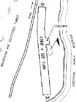
| Runways: | 16/34 |
| Longest Runway: | 16/34 is 2300 ft (701 m) long |
| Runways with an Instrument Approach: |
1U9 Airport Runway Details
| Runway 16/34 | 2300 ft x 125 ft (701 m x 38 m) | |
| Surface: | Turf - Fair condition - No special surface treatment | |
Runway 16 |
Runway 34 |
|
Elevation: |
4222.0 | 4206.0 |
Latitude: |
43-28-09.8336N | 43-27-47.1572N |
Longitude: |
115-18-37.1090W | 115-18-35.1457W |
|
Runway True Alignment: |
176 | 356 |
Glide Path Angle: |
0.0 degrees | 0.0 degrees |
Traffic Pattern: |
Left | Right |
Object at End: |
ROAD | ROAD |
Object Height: |
17 | 12 |
Distance from End: |
0 | 75 |
Object Centerline Offset: |
115 ft. right of centerline | 0 ft. left and right of centerline |
Services
Airframe Repair: |
None |
Powerplant Repair: |
None |
Bottled Oxygen: |
None |
Bulk Oxygen: |
None |
Fuel Available: |
100LL |
Landing Fees: |
No |
Parking: |
Tiedowns available |
Other Services: |
Cactus Pete's is 1/4 mile from airport. Call casino (755-6020) for code to restroom (current code is 2314). |
Maps & Diagrams
1U9 Sectional
Flight Planning
at skyvector.com
at skyvector.com