Location
Latitude: |
40-52-22.3000N (40.872861) |
Longitude: |
082-41-50.6000W (-82.697389) |
Elevation: |
1120.4 feet MSL (341 m MSL) |
Magnetic Variation: |
7.6 W (as of April 2024 from WMM2020 model) |
Time Zone: |
UTC -5.0 (Standard Time) UTC -4.0 (Daylight Savings Time) |
From City: |
02 N.M. W of Shelby, Ohio |
Found On: |
Detroit Chart |
FAA Region: |
AGL |
Contacts
Manager: |
Privately owned: |
| DOUG SCHMIDT 5085 STATE ROUTE 39 W SHELBY, OH 44875-9061 419-347-1185 |
SHELBY AIRPORT LLC PO BOX 29 SHELBY, OH 44875-0029 419-347-1185 |
Operations
Airport Status: |
Operational |
Facility Use: |
Public |
Type: |
Airport |
Activation Date: |
12/1948 |
Control tower: |
No |
Attendance (Months/Days/Hours): |
Months/Days/Hours ALL/ALL/0600-1700 |
Boundary ARTCC: |
ZOB (Cleveland) |
Responsible ARTCC: |
ZOB (Cleveland) |
Lighting Schedule: |
SS-SR |
Segmented Circle Indicator: |
No |
Traffic Pattern Altitude (MSL): |
2120 feet (646 m) |
NOTAMs Facility: |
CLE |
NOTAM-D Service: |
Yes |
International Airport of Entry: |
No |
Customs Landing Rights: |
No |
Military Landing Rights: |
No |
Civil/Military Joint Use: |
No |
Based Aircraft
| Single Engine: | 11 |
| Ultralights: | 1 |
Annual Operations (as of 07/28/2021)
| Total Operations: | 2012 | |
| Air Taxi: | 12 | 0.6% |
| GA Local: | 1500 | 74.6% |
| GA Itinerant: | 500 | 24.9% |
Communications
| CTAF: | 122.800 |
| Unicom: | 122.800 |
| Approach: | CLEVELAND 124.2 124.2 CLEVELAND ARTCC |
| Departure: | CLEVELAND 124.2 124.2 CLEVELAND ARTCC |
- APCH/DEP SVC PRVDD BY CLEVELAND APCH (CLE) 0600-0100. APCH/DEP SVC PRVDD BY CLEVELAND ARTCC (ZOB) ON FREQS 134.9/269.475 (MANSFIELD RCAG) 0100-0600.
Fixed Based Operators (FBOs) & Fuel
(Click on a business for detail)
Please help us keep this information up to date. This is a FREE SERVICE just like everything else on Airport Guide! If you see that a business needs to be added, modified, or deleted please fill out our Update Form.
To add, modify, or delete a business click here.
Please help us keep this information up to date. This is a FREE SERVICE just like everything else on Airport Guide! If you see that a business needs to be added, modified, or deleted please fill out our Update Form.
Area Code: 419 |
| Business Name | Frequency | Phone | Fuel Grade |
|---|---|---|---|
| Shelby Community Airport
Update FBO info |
347-1185, -5445 |
Flight Service Stations
| Primary | Alternate | |
| FSS on Field: | N | |
| FSS Name (ID): | Cleveland(CLE) | |
| Frequency: | ||
| Toll Free Phone: | 1-800-WX-BRIEF |
Instrument Procedures / Charts
FAA Terminal Procedures valid from 0901Z 03/21/24 to 0901Z 04/18/24.
There are various types of charts available for an airport. They are listed in the Page Type column. Here is a legend for those types:
APD - Airport Diagram
DP - Departure Procedure Charts
HOT - Hot Spots
IAP - Instrument Approach Procedure Charts
MIN - Minimums
STAR - Standard Terminal Arrival Charts
| Page Type | Page Name | Volume | Action Since Last Cycle |
|---|---|---|---|
| IAP | VOR-A | EC-2 | |
| MIN | TAKEOFF MINIMUMS | EC-2 |
Terminal Procedures are only available for airports in several countries with more being added all the time. If you are looking for a specific country's charts, please send an email to support(at)airportguide.com stating the country name. This will be used to prioritize the implementation.
Navigation Aids (Navaids) near 12G
| Dist (NM) | ID | Morse Code | Name | Type | Freq | True Hdg | Mag Hdg |
|---|---|---|---|---|---|---|---|
| 4.8 | MFD | _ _ . . _ . _ . . | Mansfield | VORTAC | 108.80 | 92 | 100 |
| 13.1 | MF | _ _ . . _ . | Manns | NDB | 372 | 119 | 127 |
| 20.8 | AAU | . _ . _ . . _ | Ashland | NDB | 329 | 74 | 82 |
| 22.7 | BUD | _ . . . . . _ _ . . | Buckeye | VOR | 109.80 | 227 | 234 |
| 27.0 | TII | _ . . . . | Tiffin | NDB | 269 | 299 | 306 |
| 33.8 | SKY | . . . _ . _ _ . _ _ | Sandusky | VOR-DME | 109.20 | 3 | 11 |
| 36.9 | FZI | . . _ . _ _ . . . . | Fostoria | NDB | 379 | 301 | 308 |
| 37.9 | DJB | _ . . . _ _ _ _ . . . | Dryer | VOR-DME | 113.60 | 39 | 47 |
| 39.5 | PCW | . _ _ . _ . _ . . _ _ | Port Clinton | NDB | 423 | 348 | 356 |
| 42.5 | MLR | _ _ . _ . . . _ . | Millersburg/Dcmsnd | NDB | 382 | 117 | 125 |
| 43.6 | APE | . _ . _ _ . . | Appleton | VORTAC | 116.70 | 173 | 181 |
| 44.9 | BNR | _ . . . _ . . _ . | Benton Ridge | NDB | 334 | 281 | 288 |
| 48.3 | FBC | . . _ . _ . . . _ . _ . | Flag City | VORTAC | 108.20 | 276 | 283 |
| 50.4 | CLE | _ . _ . . _ . . . | Cleveland | VOT | 110.40 | 49 | 57 |
| 50.7 | RUV | . _ . . . _ . . . _ | Rushsylvania | NDB | 326 | 240 | 247 |
| 51.9 | HEH | . . . . . . . . . | Newark | NDB | 524 | 168 | 176 |
| 53.1 | OS | _ _ _ . . . | Fuler | NDB | 515 | 205 | 212 |
| 53.3 | CM | _ . _ . _ _ | Sumie | NDB | 391 | 182 | 190 |
| 53.4 | CMH | _ . _ . _ _ . . . . | Port Columbus | VOT | 111.00 | 189 | 196 |
| 53.9 | CHC | _ . _ . . . . . _ . _ . | Grens | NDB | 272 | 196 | 203 |
Nearby Airports with Fuel
Notices to Airmen (NOTAMS)
Remarks
| A110*G | THIS AIRPORT HAS BEEN SURVEYED BY THE NATIONAL GEODETIC SURVEY. |
| A110-1 | FOR CD CTC CLEVELAND APCH AT 216-352-2323, WHEN APCH CLSD CTC CLEVELAND ARTCC AT 440-774-0223. |
| A110-2 | RWY 18/36: 35 FT PLINE, 975 FT NORTH OF RWY END 18, NOT MKD; 95 FT PLINE, 1810 FT SOUTH OF RWY END 36, NOT MKD. |
| A16 | HOME 419-347-8543. |
| A40-18/36 | NSTD LIRL DUE TO RWY 18 THR LGTS 220 FT FM RWY END; RWY LGTS 62 FT FM EAST EDGE & 47 FT FM WEST EDGE. |
| A58-18 | ROAD 165'FM RWY END 125'R. |
| A58-36 | SEASONAL CROPS 75 FT L/R, UP TO 10 FT. |
| E111 | ESTABD BFR 1959. |
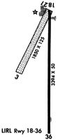
Runways
Runway Summary
| Runways: | 03/21 18/36 |
| Longest Runway: | 18/36 is 3174 ft (967 m) long |
| Runways with an Instrument Approach: |
12G Airport Runway Details
| Runway 03/21 | 1890 ft x 125 ft (576 m x 38 m) | |
| Runway Length Source: | NGS as of 11/26/2001 | |
| Surface: | Turf - Good condition - No special surface treatment | |
Runway 03 |
Runway 21 |
|
Elevation: |
1120.4 | 1118.3 |
Latitude: |
40-52-19.7843N | 40-52-36.6936N |
Longitude: |
082-41-59.2996W | 082-41-48.8553W |
|
Runway True Alignment: |
025 | 205 |
Glide Path Angle: |
0.0 degrees | 0.0 degrees |
Traffic Pattern: |
Left | Left |
Runway Markings Type: |
None | None |
Object at End: |
TREE | BLDG |
Object Height: |
75 | 42 |
Distance from End: |
345 | 427 |
Object Centerline Offset: |
70 ft. left of centerline | 68 ft. left of centerline |
REIL: |
No | No |
Touchdown Lights: |
No | No |
Centerline Lights: |
No | No |
| Runway 18/36 | 3174 ft x 50 ft (967 m x 15 m) | |
| Runway Length Source: | NGS as of 11/26/2001 | |
| Surface: | Turf - Good condition - No special surface treatment | |
| Runway Edge Lights: | Non-standard lighting system Intensity | |
Runway Weight Bearing Capacity (in thousands of pounds) |
||
| Single Wheel Landing Gear: | 5.0 | |
Runway 18 |
Runway 36 |
|
Elevation: |
1117.5 | 1119.4 |
Latitude: |
40-52-34.3915N | 40-52-03.0360N |
Longitude: |
082-41-48.8020W | 082-41-48.1906W |
|
Runway True Alignment: |
179 | 359 |
Glide Path Angle: |
0.0 degrees | 0.0 degrees |
Traffic Pattern: |
Left | Left |
Runway Markings Type: |
Basic | Basic |
Runway Markings Condition: |
Good | Good |
Object at End: |
ROAD | PLINE |
Object Height: |
15 | 94 |
Distance from End: |
201 | 1810 |
Object Centerline Offset: |
70 ft. left of centerline | 68 ft. left of centerline |
REIL: |
No | No |
Touchdown Lights: |
No | No |
Centerline Lights: |
No | No |
Services
Airframe Repair: |
Major |
Powerplant Repair: |
Major |
Bottled Oxygen: |
None |
Bulk Oxygen: |
None |
Fuel Available: |
100LL, Jet A-1, Jet A-1+ |
Landing Fees: |
No |
Parking: |
Hangars and tiedowns available |
Maps & Diagrams
12G Sectional
Flight Planning
at skyvector.com
at skyvector.com