Location
Latitude: |
37-06-27.8000N (37.107722) |
Longitude: |
079-35-32.9000W (-79.592472) |
Elevation: |
892.2 feet MSL (272 m MSL) |
Magnetic Variation: |
9 W (as of April 2024 from WMM2020 model) |
Time Zone: |
UTC -5.0 (Standard Time) UTC -4.0 (Daylight Savings Time) |
From City: |
04 N.M. SE of Moneta, Virginia |
Found On: |
Cincinnati Chart |
FAA Region: |
AEA |
Contacts
Manager: |
Privately owned: |
| MOE BAZAZAN 1090 CUTLASS RD MONETA, VA 24121 540-297-4859 |
SMITH MOUNTAIN LAKE AIRPORT, LLC. 1090 CUTLASS RD MONETA, VA 24121 540-297-4859 |
Operations
Airport Status: |
Operational |
Facility Use: |
Public |
Type: |
Airport |
Activation Date: |
03/1962 |
Control tower: |
No |
Attendance (Months/Days/Hours): |
Months/Days/Hours ALL/ALL/ALL |
Boundary ARTCC: |
ZDC (Washington) |
Responsible ARTCC: |
ZDC (Washington) |
Segmented Circle Indicator: |
No |
Traffic Pattern Altitude (MSL): |
1892 feet (577 m) |
NOTAMs Facility: |
DCA |
NOTAM-D Service: |
Yes |
International Airport of Entry: |
No |
Customs Landing Rights: |
No |
Military Landing Rights: |
No |
Civil/Military Joint Use: |
No |
Based Aircraft
| Single Engine: | 34 |
| Multi Engine: | 3 |
Annual Operations (as of 07/31/2023)
| Total Operations: | 5460 | |
| Air Taxi: | 7 | 0.1% |
| GA Local: | 4971 | 91.0% |
| GA Itinerant: | 479 | 8.8% |
| Military Aircraft: | 3 | 0.1% |
Communications
| CTAF: | 122.975 |
| Unicom: | 122.975 |
| Approach: | ROANOKE 135.0 135.0 |
| Departure: | ROANOKE 135.0 135.0 |
Fixed Based Operators (FBOs) & Fuel
(Click on a business for detail)
Please help us keep this information up to date. This is a FREE SERVICE just like everything else on Airport Guide! If you see that a business needs to be added, modified, or deleted please fill out our Update Form.
To add, modify, or delete a business click here.
Please help us keep this information up to date. This is a FREE SERVICE just like everything else on Airport Guide! If you see that a business needs to be added, modified, or deleted please fill out our Update Form.
Area Code: 540 |
| Business Name | Frequency | Phone | Fuel Grade |
|---|
Flight Service Stations
| Primary | Alternate | |
| FSS on Field: | N | |
| FSS Name (ID): | Leesburg(DCA) | |
| Frequency: | ||
| Toll Free Phone: | 1-800-WX-BRIEF |
Instrument Procedures / Charts
FAA Terminal Procedures valid from 0901Z 03/21/24 to 0901Z 04/18/24.
There are various types of charts available for an airport. They are listed in the Page Type column. Here is a legend for those types:
APD - Airport Diagram
DP - Departure Procedure Charts
HOT - Hot Spots
IAP - Instrument Approach Procedure Charts
MIN - Minimums
STAR - Standard Terminal Arrival Charts
| Page Type | Page Name | Volume | Action Since Last Cycle |
|---|---|---|---|
| IAP | RNAV (GPS) RWY 23 | NE-3 | |
| MIN | TAKEOFF MINIMUMS | NE-3 |
Terminal Procedures are only available for airports in several countries with more being added all the time. If you are looking for a specific country's charts, please send an email to support(at)airportguide.com stating the country name. This will be used to prioritize the implementation.
Navigation Aids (Navaids) near W91
| Dist (NM) | ID | Morse Code | Name | Type | Freq | True Hdg | Mag Hdg |
|---|---|---|---|---|---|---|---|
| 15.0 | VIT | . . . _ . . _ | Vinton | NDB | 277 | 292 | 301 |
| 19.1 | LY | . _ . . _ . _ _ | Bojar | NDB | 385 | 60 | 69 |
| 19.2 | LYH | . _ . . _ . _ _ . . . . | Lynchburg | VOR-DME | 109.20 | 62 | 71 |
| 22.6 | ODR | _ _ _ _ . . . _ . | Woodrum | VOR | 114.90 | 305 | 314 |
| 26.9 | ROA | . _ . _ _ _ . _ | Roanoke | VOR-DME | 109.40 | 301 | 310 |
| 34.6 | DAN | _ . . . _ _ . | Danville | VOR | 113.10 | 159 | 168 |
| 34.8 | UV | . . _ . . . _ | Bales | NDB | 396 | 206 | 215 |
| 38.0 | SBV | . . . _ . . . . . . _ | South Boston | VORTAC | 110.40 | 132 | 141 |
| 39.2 | TEC | _ . _ . _ . | Tech | NDB | 368 | 279 | 288 |
| 42.4 | OQA | _ _ _ _ _ . _ . _ | Rockingham County | FAN MARKER | 195 | 204 | |
| 44.3 | SIF | . . . . . . . _ . | Slammer | NDB | 423 | 190 | 199 |
| 52.9 | MOL | _ _ _ _ _ . _ . . | Montebello | VOR-DME | 115.30 | 25 | 34 |
| 53.6 | PSK | . _ _ . . . . _ . _ | Pulaski | VORTAC | 116.80 | 269 | 278 |
| 57.1 | FVX | . . _ . . . . _ _ . . _ | Farmville | NDB | 367 | 74 | 83 |
| 58.1 | LW | . _ . . . _ _ | Bushi | NDB | 346 | 314 | 323 |
| 58.3 | HUR | . . . . . . _ . _ . | Person | NDB | 220 | 154 | 163 |
| 59.2 | LWB | . _ . . . _ _ _ . . . | Greenbrier | DME | 116.05 | 320 | 329 |
| 62.5 | HLX | . . . . . _ . . _ . . _ | Hillsville | NDB | 269 | 250 | 259 |
| 63.1 | AZW | . _ _ _ . . . _ _ | Mount Airy | NDB | 223 | 226 | 235 |
| 66.4 | GSO | _ _ . . . . _ _ _ | Greensboro | VORTAC | 116.20 | 196 | 205 |
Nearby Airports with Fuel
Notices to Airmen (NOTAMS)
Remarks
| A110-1 | DEER ON & INVOF ARPT. |
| A110-2 | ROA TWR SVCS AVBL AT 540-563-1307. |
| A110-3 | LNDG FEE FOR ALL ACFT OVR 5500 LBS PUBLISHED MAX GW. |
| A110-4 | CLSD TO TRANSIENT PRACTICE LANDINGS. CLSD TO TRANSIENT ACFT PERFORMING TGL AND PLA. |
| A42-05 | RWY 05 MRKGS WRONG SIZE ARROWS. |
| A42-23 | RWY 23 MRKGS WRONG RWY WIDTH. |
| A57-05 | APCH SLOPE 7:1 TO DSPLCD THR BASED. |
| A58-05 | RY 05 HAS +12 FT ROAD AT THLD 100 FT R. PWR POLE 128 FT RIGHT OF APCH 86 FT FM THLD. |
| A70-FUEL-10 | 0LL 24-HR SELF-SERVE FUEL AVAILABLE WITH CREDIT CARD. |
| A75 | OVERNIGHT FEE |
Runways
Runway Summary
| Runways: | 05/23 |
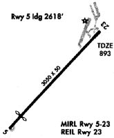
| Longest Runway: | 05/23 is 3058 ft (932 m) long |
| Runways with an Instrument Approach: |
W91 Airport Runway Details
| Runway 05/23 | 3058 ft x 50 ft (932 m x 15 m) | |
| Runway Length Source: | OWNER as of 11/05/2020 | |
| Surface: | Asphalt - Fair condition - No special surface treatment | |
| Runway Edge Lights: | Medium Intensity | |
Runway 05 |
Runway 23 |
|
Elevation: |
854.7 | 892.0 |
Latitude: |
37-06-17.1160N | 37-06-38.5190N |
Longitude: |
079-35-46.2470W | 079-35-19.5940W |
|
Runway True Alignment: |
045 | 225 |
Glide Path Angle: |
0.0 degrees | 0.0 degrees |
Traffic Pattern: |
Left | Left |
Runway Markings Type: |
Nonstandard (other than numbers only) | Nonstandard (other than numbers only) |
Runway Markings Condition: |
Good | Good |
Object at End: |
TREES | TREE |
Object Height: |
43 | 23 |
Distance from End: |
290 | 238 |
Object Centerline Offset: |
127 ft. right of centerline | 122 ft. left of centerline |
REIL: |
No | Yes |
Threshold Elevation: |
864.5 | |
Displaced Threshold: |
250 | |
Threshold Latitude: |
37-06-18.8500N | |
Threshold Longitude: |
079-35-44.0600W |
Services
Airframe Repair: |
Major |
Powerplant Repair: |
Major |
Bottled Oxygen: |
None |
Bulk Oxygen: |
None |
Fuel Available: |
100LL, Jet A, Jet A+ |
Landing Fees: |
No |
Parking: |
Hangars and tiedowns available |
Maps & Diagrams
W91 Sectional
Flight Planning
at skyvector.com
at skyvector.com