Location
Latitude: |
61-42-01.8340N (61.700509) |
Longitude: |
157-09-57.0590W (-157.16585) |
Elevation: |
191.6 feet MSL (58 m MSL) |
Magnetic Variation: |
11.9 E (as of April 2024 from WMM2020 model) |
Time Zone: |
UTC -9.0 (Standard Time) UTC -8.0 (Daylight Savings Time) |
From City: |
00 N.M. E of Sleetmute, Alaska |
Found On: |
Mc Grath Chart |
FAA Region: |
AAL |
Contacts
Manager: |
Publicly owned: |
| ROXANNE EVAN P.O. BOX 73 ANIAK, AK 99557-7300 907-675-4345 |
ALASKA DOT&PF CENTRAL REGION PO BOX 196900 ANCHORAGE, AK 99519-6900 907-269-0749 |
Operations
Airport Status: |
Operational |
Facility Use: |
Public |
Type: |
Airport |
Activation Date: |
11/1949 |
Control tower: |
No |
Attendance (Months/Days/Hours): |
Months/Days/Hours Unattended |
Boundary ARTCC: |
ZAN (Anchorage) |
Responsible ARTCC: |
ZAN (Anchorage) |
Lighting Schedule: |
SEE RMK |
Segmented Circle Indicator: |
No |
Traffic Pattern Altitude (MSL): |
1192 feet (363 m) |
NOTAMs Facility: |
SLQ |
NOTAM-D Service: |
Yes |
International Airport of Entry: |
No |
Customs Landing Rights: |
No |
Military Landing Rights: |
Yes |
Civil/Military Joint Use: |
No |
Based Aircraft
Annual Operations (as of 12/31/2022)
| Total Operations: | 500 | |
| Air Taxi: | 500 | 100.0% |
Communications
| CTAF: | 122.800 |
| Unicom: | 122.800 |
| AWOS-3P: | 134.85 (907-449-4226) |
- APCH/DEP CTL SVC PRVVD ANCHORAGE ARTCC (ZAN) ON 128.5/379.9 (SPARREVOHN RCAG).
Fixed Based Operators (FBOs) & Fuel
(Click on a business for detail)
Please help us keep this information up to date. This is a FREE SERVICE just like everything else on Airport Guide! If you see that a business needs to be added, modified, or deleted please fill out our Update Form.
To add, modify, or delete a business click here.
Please help us keep this information up to date. This is a FREE SERVICE just like everything else on Airport Guide! If you see that a business needs to be added, modified, or deleted please fill out our Update Form.
Area Code: 907 |
| Business Name | Frequency | Phone | Fuel Grade |
|---|
Flight Service Stations
| Primary | Alternate | |
| FSS on Field: | N | |
| FSS Name (ID): | Kenai(ENA) | |
| Frequency: | ||
| Toll Free Phone: | 1-866-864-1737 |
Instrument Procedures / Charts
FAA Terminal Procedures valid from 0901Z 03/21/24 to 0901Z 04/18/24.
There are various types of charts available for an airport. They are listed in the Page Type column. Here is a legend for those types:
APD - Airport Diagram
DP - Departure Procedure Charts
HOT - Hot Spots
IAP - Instrument Approach Procedure Charts
MIN - Minimums
STAR - Standard Terminal Arrival Charts
| Page Type | Page Name | Volume | Action Since Last Cycle |
|---|---|---|---|
| IAP | RNAV (GPS) RWY 33 | AK-1 | |
| MIN | ALTERNATE MINIMUMS | AK-1 | |
| MIN | TAKEOFF MINIMUMS | AK-1 | |
| ODP | SPARREVOHN ONE (OBSTACLE) (RNAV) | AK-1 |
Terminal Procedures are only available for airports in several countries with more being added all the time. If you are looking for a specific country's charts, please send an email to support(at)airportguide.com stating the country name. This will be used to prioritize the implementation.
Navigation Aids (Navaids) near SLQ
| Dist (NM) | ID | Morse Code | Name | Type | Freq | True Hdg | Mag Hdg |
|---|---|---|---|---|---|---|---|
| 56.9 | SQA | . . . _ _ . _ . _ | Sparrevohn | VOR-DME | 117.20 | 128 | 116 |
| 58.3 | CRN | _ . _ . . _ . _ . | Cairn Mountain | NDB | 281 | 127 | 115 |
| 69.6 | ANI | . _ _ . . . | Aniak | NDB | 359 | 265 | 254 |
| 86.6 | MCG | _ _ _ . _ . _ _ . | Mc Grath | VORTAC | 115.50 | 29 | 17 |
| 87.2 | VTR | . . . _ _ . _ . | Takotna River | NDB | 350 | 30 | 18 |
Nearby Airports with Fuel
| Dist (NM) | Name (Airport IDs) | True Hdg | Mag Hdg | Fuel Grade |
|---|---|---|---|---|
| 29.4 | Crooked Creek Airport (CKD CJX) |
290 | 279 | MOGAS |
| 68.2 | Aniak Airport (ANI PANI ANI) |
265 | 254 | 100LL, Jet A |
| 86.8 | Mc Grath Airport (MCG PAMC MCG) |
29 | 17 | 100LL, Jet A-1+ |
Notices to Airmen (NOTAMS)
Remarks
| A110-2 | RWY CONDITION NOT MONITORED; RECOMMEND VISUAL INSPECTION PRIOR TO USING. |
| A110-3 | ATVS NEAR OR ON RWY. |
| A110-4 | RED DEVIL ARPT 8 MILES NW. |
| A110-5 | WX CAMERA AVBL ON INTERNET AT HTTPS://WEATHERCAMS.FAA.GOV. |
| A110-6 | RWY 15/33 N 500 FT SOFT |
| A110-7 | COLD TEMPERATURE AIRPORT. ALTITUDE CORRECTION REQUIRED AT OR BELOW -37C. |
| A33-15/33 | RWY 15/33 SOFT SPOTS ON RWY WHEN WET. |
| A42-15 | RWY END MARKED WITH LGTS. |
| A42-33 | RWY END MARKED WITH LGTS. |
| A70-FUEL-10 | 0LL FUEL AVBL - CTAF OR (907) 449-4227. |
| A81-APT | ACTVT MIRL RWY 15/33 - CTAF. |
| E111 | ESTABD PRIOR TO 1959. |
Runways
Runway Summary
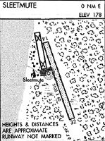
| Runways: | 15/33 |
| Longest Runway: | 15/33 is 3100 ft (945 m) long |
| Runways with an Instrument Approach: |
SLQ Airport Runway Details
| Runway 15/33 | 3100 ft x 60 ft (945 m x 18 m) | |
| Runway Length Source: | 3RD PARTY SURVEY as of 08/18/2018 | |
| Surface: | Gravel - Fair condition - No special surface treatment | |
| Runway Edge Lights: | Medium Intensity | |
Runway 15 |
Runway 33 |
|
Elevation: |
190.9 | 191.3 |
Latitude: |
61-42-16.6632N | 61-41-47.0049N |
Longitude: |
157-10-04.6546W | 157-09-49.4650W |
|
Runway True Alignment: |
166 | 346 |
Glide Path Angle: |
0.0 degrees | 0.0 degrees |
Traffic Pattern: |
Left | Left |
Runway Markings Type: |
None | None |
Runway Markings Condition: |
Fair | Fair |
Object at End: |
BRUSH | TREE |
Object Height: |
12 | 28 |
Distance from End: |
0 | 0 |
Object Centerline Offset: |
110 ft. left and right of centerline | 120 ft. left and right of centerline |
Services
Airframe Repair: |
Minor |
Powerplant Repair: |
Minor |
Fuel Available: |
100LL, Jet A-1+ |
Landing Fees: |
No |
Parking: |
Hangars and tiedowns available |
Maps & Diagrams
SLQ Sectional
Flight Planning
at skyvector.com
at skyvector.com