Location
Latitude: |
61-46-29.6050N (61.77489) |
Longitude: |
161-19-09.8354W (-161.319399) |
Elevation: |
58.3 feet MSL (18 m MSL) |
Magnetic Variation: |
10 E (as of April 2024 from WMM2020 model) |
Time Zone: |
UTC -9.0 (Standard Time) UTC -8.0 (Daylight Savings Time) |
From City: |
00 N.M. SE of Russian Mission, Alaska |
Found On: |
Mc Grath Chart |
FAA Region: |
AAL |
Contacts
Manager: |
Publicly owned: |
| ERIK WEINGARTH PO BOX 135 ST MARYS, AK 99658 907-438-2416 |
ALASKA DOT&PF NORTHERN REGION 2301 PEGER RD FAIRBANKS, AK 99709 907-451-2200 |
Operations
Airport Status: |
Operational |
Facility Use: |
Public |
Type: |
Airport |
Activation Date: |
06/1963 |
Control tower: |
No |
Attendance (Months/Days/Hours): |
Months/Days/Hours Unattended |
Boundary ARTCC: |
ZAN (Anchorage) |
Responsible ARTCC: |
ZAN (Anchorage) |
Lighting Schedule: |
SEE RMK |
Segmented Circle Indicator: |
Yes |
Traffic Pattern Altitude (MSL): |
1058 feet (322 m) |
NOTAMs Facility: |
RSH |
NOTAM-D Service: |
Yes |
International Airport of Entry: |
No |
Customs Landing Rights: |
No |
Military Landing Rights: |
Yes |
Civil/Military Joint Use: |
No |
Based Aircraft
Annual Operations (as of 12/31/2022)
| Total Operations: | 500 | |
| Air Taxi: | 500 | 100.0% |
Communications
| CTAF: | 122.900 |
| AWOS-3P: | 118.375 (907-584-5521) |
- APCH/DEP SVC PRVDD BY ANCHORAGE ARTCC ON FREQS 118.15/251.05 (ANIAK RCAG) .
Fixed Based Operators (FBOs) & Fuel
(Click on a business for detail)
Please help us keep this information up to date. This is a FREE SERVICE just like everything else on Airport Guide! If you see that a business needs to be added, modified, or deleted please fill out our Update Form.
To add, modify, or delete a business click here.
Please help us keep this information up to date. This is a FREE SERVICE just like everything else on Airport Guide! If you see that a business needs to be added, modified, or deleted please fill out our Update Form.
Area Code: 907 |
| Business Name | Frequency | Phone | Fuel Grade |
|---|
Flight Service Stations
| Primary | Alternate | |
| FSS on Field: | N | |
| FSS Name (ID): | Kenai(ENA) | |
| Frequency: | ||
| Toll Free Phone: | 1-866-864-1737 |
Instrument Procedures / Charts
FAA Terminal Procedures valid from 0901Z 03/21/24 to 0901Z 04/18/24.
There are various types of charts available for an airport. They are listed in the Page Type column. Here is a legend for those types:
APD - Airport Diagram
DP - Departure Procedure Charts
HOT - Hot Spots
IAP - Instrument Approach Procedure Charts
MIN - Minimums
STAR - Standard Terminal Arrival Charts
| Page Type | Page Name | Volume | Action Since Last Cycle |
|---|---|---|---|
| IAP | RNAV (GPS) RWY 18 | AK-1 | |
| IAP | RNAV (GPS) RWY 36 | AK-1 | |
| MIN | ALTERNATE MINIMUMS | AK-1 | |
| MIN | TAKEOFF MINIMUMS | AK-1 |
Terminal Procedures are only available for airports in several countries with more being added all the time. If you are looking for a specific country's charts, please send an email to support(at)airportguide.com stating the country name. This will be used to prioritize the implementation.
Navigation Aids (Navaids) near RSH
| Dist (NM) | ID | Morse Code | Name | Type | Freq | True Hdg | Mag Hdg |
|---|---|---|---|---|---|---|---|
| 50.2 | ANI | . _ _ . . . | Aniak | NDB | 359 | 101 | 91 |
| 58.0 | SMA | . . . _ _ . _ | St Marys | NDB | 230 | 287 | 277 |
| 60.9 | ANV | . _ _ . . . . _ | Anvik | NDB | 365 | 30 | 20 |
| 61.1 | OSE | _ _ _ . . . . | Oscarville | NDB | 251 | 195 | 185 |
| 61.2 | BET | _ . . . . _ | Bethel | VORTAC | 114.10 | 193 | 183 |
Nearby Airports with Fuel
| Dist (NM) | Name (Airport IDs) | True Hdg | Mag Hdg | Fuel Grade |
|---|---|---|---|---|
| 51.8 | Aniak Airport (ANI PANI ANI) |
102 | 91 | 100LL, Jet A |
| 61.6 | Bethel Airport (BET PABE BET) |
194 | 184 | 100, 100LL, Jet A, Jet A-1 |
| 90.3 | Crooked Creek Airport (CKD CJX) |
84 | 73 | MOGAS |
Notices to Airmen (NOTAMS)
Remarks
| A110-2 | SEAPLANES OPERATE N-S IN YUKON RIVER AND E-W IN NUNVOTCHUK LAKE. WATCH FOR FISH NETS CLOSE TO SHORE. |
| A110-4 | RWY CONDITION NOT MONITORED - RECOMMEND VISUAL INSPECTION PRIOR TO LNDG. |
| A110-5 | WX CAMERA AVBL ON INTERNET AT HTTPS://WEATHERCAMS.FAA.GOV |
| A110-6 | COLD TEMPERATURE AIRPORT. ALTITUDE CORRECTION REQUIRED AT OR BELOW -31C. |
| A43-36 | PAPI UNUSBL BYD 9 DEGS RIGHT OF CNTRLN. |
| A81-APT | ACTVT REIL RWY 18 & 36; PAPI RWY 36; MIRL RWY 18/36; WINDSOCK - CTAF. |
| A81-BCN | ACTVT ROTG BCN - CTAF. |
Runways
Runway Summary
| Runways: | 18/36 18W/36W |
| Longest Runway: | 18/36 is 3620 ft (1103 m) long |
| Runways with an Instrument Approach: |
RSH Airport Runway Details
| Runway 18/36 | 3620 ft x 100 ft (1103 m x 30 m) | |
| Runway Length Source: | 3RD PARTY SURVEY as of 06/20/2010 | |
| Surface: | Gravel - Good condition - No special surface treatment | |
| Runway Edge Lights: | Medium Intensity | |
Runway 18 |
Runway 36 |
|
Elevation: |
58.3 | 58.2 |
Latitude: |
61-46-47.2584N | 61-46-11.9179N |
Longitude: |
161-19-04.9752W | 161-19-14.7177W |
|
Runway True Alignment: |
188 | 008 |
Glide Path Angle: |
0.0 degrees | 4.2 degrees |
Traffic Pattern: |
Left | Left |
Object at End: |
TREES | TREES |
Object Height: |
26 | 30 |
Distance from End: |
0 | 0 |
Object Centerline Offset: |
230 ft. left and right of centerline | 240 ft. left and right of centerline |
Visual Glide Slope Indicators: |
4-Light PAPI On Left Side Of Runway | |
REIL: |
Yes | Yes |
Threshold Crossing Height: |
35 |
| Runway 18W/36W | 3000 ft x 500 ft (914 m x 152 m) | |
| Surface: | Gravel - Good condition - No special surface treatment | |
Runway 18W |
Runway 36W |
|
Glide Path Angle: |
0.0 degrees | 0.0 degrees |
Object Centerline Offset: |
230 ft. left and right of centerline | 240 ft. left and right of centerline |
Services
Fuel Available: |
MOGAS |
Landing Fees: |
No |
Maps & Diagrams
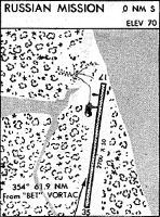
RSH Sectional
Flight Planning
at skyvector.com
at skyvector.com