Location
Latitude: |
28-05-10.4000N (28.086222) |
Longitude: |
097-02-37.3000W (-97.043694) |
Elevation: |
23.8 feet MSL (7 m MSL) |
Magnetic Variation: |
2.8 E (as of April 2024 from WMM2020 model) |
Time Zone: |
UTC -6.0 (Standard Time) UTC -5.0 (Daylight Savings Time) |
From City: |
04 N.M. N of Rockport, Texas |
Found On: |
San Antonio Chart |
FAA Region: |
ASW |
Contacts
Manager: |
Publicly owned: |
| MIKE GEER PO BOX 1270 ROCKPORT, TX 78382 361-790-0141 |
ARANSAS COUNTY 2840 HWY 35 N ROCKPORT, TX 78382 817-480-8861 |
Operations
Airport Status: |
Operational |
Facility Use: |
Public |
Type: |
Airport |
Activation Date: |
04/1944 |
Control tower: |
No |
Attendance (Months/Days/Hours): |
Months/Days/Hours ALL/ALL/0730-1730 |
Boundary ARTCC: |
ZHU (Houston) |
Responsible ARTCC: |
ZHU (Houston) |
Lighting Schedule: |
SEE RMK |
Segmented Circle Indicator: |
Yes |
Traffic Pattern Altitude (MSL): |
1024 feet (312 m) |
NOTAMs Facility: |
RKP |
NOTAM-D Service: |
Yes |
International Airport of Entry: |
No |
Customs Landing Rights: |
No |
Military Landing Rights: |
Yes |
Civil/Military Joint Use: |
No |
Based Aircraft
| Single Engine: | 32 |
| Multi Engine: | 5 |
| Jet Engine: | 2 |
| GA Helicopters: | 4 |
Annual Operations (as of 04/17/2023)
| Total Operations: | 105000 | |
| Air Taxi: | 5000 | 4.8% |
| GA Local: | 20000 | 19.0% |
| GA Itinerant: | 5000 | 4.8% |
| Military Aircraft: | 75000 | 71.4% |
Communications
| CTAF: | 123.050 |
| Unicom: | 123.050 |
| Approach: | CORPUS 120.9 120.9 120.9 |
| Departure: | CORPUS 120.9 120.9 120.9 |
| ASOS: | 119.275 (361-729-2372) |
Fixed Based Operators (FBOs) & Fuel
(Click on a business for detail)
Please help us keep this information up to date. This is a FREE SERVICE just like everything else on Airport Guide! If you see that a business needs to be added, modified, or deleted please fill out our Update Form.
To add, modify, or delete a business click here.
Please help us keep this information up to date. This is a FREE SERVICE just like everything else on Airport Guide! If you see that a business needs to be added, modified, or deleted please fill out our Update Form.
Area Code: 361 |
| Business Name | Frequency | Phone | Fuel Grade |
|---|---|---|---|
| Aransas Co Airport Services
Update FBO info |
Unicom 122.8 | 790-0141 | 100LL, Jet A |

|
 Texaco |
100LL - 1.79 USD per gallon on 1/12/02 |
24 Hour Self Serve Credit Card Pumps |
| Clyde (Tom) Reynolds, CFII
Update FBO info |
361-946-4911 cellular phone |
Flight Service Stations
| Primary | Alternate | |
| FSS on Field: | N | |
| FSS Name (ID): | San Angelo(SJT) | |
| Frequency: | ||
| Toll Free Phone: | 1-800-WX-BRIEF |
Instrument Procedures / Charts
FAA Terminal Procedures valid from 0901Z 03/21/24 to 0901Z 04/18/24.
There are various types of charts available for an airport. They are listed in the Page Type column. Here is a legend for those types:
APD - Airport Diagram
DP - Departure Procedure Charts
HOT - Hot Spots
IAP - Instrument Approach Procedure Charts
MIN - Minimums
STAR - Standard Terminal Arrival Charts
| Page Type | Page Name | Volume | Action Since Last Cycle |
|---|---|---|---|
| IAP | RNAV (GPS) RWY 14 | SC-3 | |
| IAP | RNAV (GPS) RWY 18 | SC-3 | |
| IAP | RNAV (GPS) RWY 32 | SC-3 | |
| IAP | RNAV (GPS) RWY 36 | SC-3 | |
| IAP | VOR OR TACAN-A | SC-3 | |
| MIN | ALTERNATE MINIMUMS | SC-3 | |
| MIN | TAKEOFF MINIMUMS | SC-3 |
Terminal Procedures are only available for airports in several countries with more being added all the time. If you are looking for a specific country's charts, please send an email to support(at)airportguide.com stating the country name. This will be used to prioritize the implementation.
Navigation Aids (Navaids) near RKP
| Dist (NM) | ID | Morse Code | Name | Type | Freq | True Hdg | Mag Hdg |
|---|---|---|---|---|---|---|---|
| 14.4 | MNO | _ _ _ . _ _ _ | Mellon Ranch | NDB | 375 | 323 | 320 |
| 23.9 | CRP | _ . _ . . _ . . _ _ . | Corpus Christi | VORTAC | 115.50 | 242 | 239 |
| 27.4 | NGP | _ . _ _ . . _ _ . | Truax | TACAN | 114.00 | 209 | 206 |
| 49.0 | VCT | . . . _ _ . _ . _ | Victoria | VOR-DME | 109.00 | 3 | 0 |
| 53.6 | NQI | _ . _ _ . _ . . | Kingsville | TACAN | 117.80 | 229 | 226 |
| 54.1 | NOG | _ . _ _ _ _ _ . | Orange Grove | TACAN | 133.60 | 258 | 255 |
| 55.8 | ALI | . _ . _ . . . . | Alice | VOR | 114.50 | 248 | 245 |
| 56.3 | PSX | . _ _ . . . . _ . . _ | Palacios | VORTAC | 117.30 | 43 | 40 |
| 62.3 | TKB | _ _ . _ _ . . . | Kleberg County | NDB | 347 | 242 | 239 |
| 63.6 | THX | _ . . . . _ . . _ | Three Rivers | VORTAC | 111.40 | 293 | 290 |
| 73.7 | OKT | _ _ _ _ . _ _ | Yoakum | NDB | 350 | 356 | 353 |
| 77.9 | BKS | _ . . . _ . _ . . . | Brooks County | NDB | 353 | 227 | 224 |
| 82.0 | BYY | _ . . . _ . _ _ _ . _ _ | Bay City | NDB | 344 | 49 | 47 |
| 84.4 | ARM | . _ . _ . _ _ | Wharton | NDB | 245 | 33 | 30 |
Nearby Airports with Fuel
Notices to Airmen (NOTAMS)
Remarks
| A110-1 | CREW CARS AVAILABLE FIRST COME OR RESERVATION. |
| A110-2 | CREW REST FACILITY INCLUDING SLEEP ROOMS AND SHOWERS AVAILABLE WITH PRIOR COORDINATION W/ARPT. |
| A57-32 | APCH SLOPE 50:1 FM DSPLCD THR. |
| A81-APT | MIRL RWY 14/32 & 18/36 PRESET LOW INTST. TO INCR INTST & ACTVT REIL 14 - CTAF. |
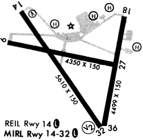
Runways
Runway Summary
| Runways: | 14/32 18/36 |
| Longest Runway: | 14/32 is 5608 ft (1709 m) long |
| Runways with an Instrument Approach: |
RKP Airport Runway Details
| Runway 14/32 | 5608 ft x 100 ft (1709 m x 30 m) | |
| Runway Length Source: | NGS as of 01/08/1998 | |
| Surface: | Asphalt - Good condition - No special surface treatment | |
| Runway Edge Lights: | Medium Intensity | |
Runway Weight Bearing Capacity (in thousands of pounds) |
||
| Single Wheel Landing Gear: | 45.0 | |
| Dual Wheel Landing Gear: | 80.0 | |
| Dual Tandem Wheel Landing Gear: | 140.0 | |
Runway 14 |
Runway 32 |
|
Elevation: |
14.8 | 23.8 |
Latitude: |
28-05-33.5548N | 28-04-47.8151N |
Longitude: |
097-03-05.6671W | 097-02-30.1645W |
|
Runway True Alignment: |
145 | 325 |
Glide Path Angle: |
3.0 degrees | 3.0 degrees |
Traffic Pattern: |
Left | Right |
Runway Markings Type: |
Nonprecision Instrument | Nonprecision Instrument |
Runway Markings Condition: |
Fair | Fair |
Object at End: |
BRUSH | PLINE |
Object Height: |
10 | 33 |
Object Marked/Lighted?: |
Marked | |
Distance from End: |
560 | 872 |
Object Centerline Offset: |
0 ft. left and right of centerline | 250 ft. right of centerline |
Visual Glide Slope Indicators: |
4-Light PAPI On Left Side Of Runway | 4-Light PAPI On Left Side Of Runway |
REIL: |
Yes | No |
Threshold Crossing Height: |
35 | 25 |
Threshold Elevation: |
23.1 | |
Displaced Threshold: |
565 | |
Threshold Latitude: |
28-04-52.4220N | |
Threshold Longitude: |
097-02-33.7399W |
| Runway 18/36 | 4498 ft x 100 ft (1371 m x 30 m) | |
| Runway Length Source: | NGS as of 01/08/1998 | |
| Surface: | Asphalt - Good condition - No special surface treatment | |
| Runway Edge Lights: | Medium Intensity | |
Runway Weight Bearing Capacity (in thousands of pounds) |
||
| Single Wheel Landing Gear: | 45.0 | |
| Dual Wheel Landing Gear: | 80.0 | |
| Dual Tandem Wheel Landing Gear: | 140.0 | |
Runway 18 |
Runway 36 |
|
Elevation: |
20.0 | 23.1 |
Latitude: |
28-05-31.9007N | 28-04-48.1015N |
Longitude: |
097-02-19.5238W | 097-02-28.6473W |
|
Runway True Alignment: |
190 | 010 |
Glide Path Angle: |
3.0 degrees | 3.0 degrees |
Traffic Pattern: |
Right | Left |
Runway Markings Type: |
Nonprecision Instrument | Nonprecision Instrument |
Runway Markings Condition: |
Good | Good |
Object at End: |
TREES | PLINE |
Object Height: |
30 | 42 |
Object Marked/Lighted?: |
Lighted | |
Distance from End: |
1035 | 922 |
Object Centerline Offset: |
0 ft. left and right of centerline | 250 ft. right of centerline |
Visual Glide Slope Indicators: |
2-Light PAPI On Left Side Of Runway | 2-Light PAPI On Left Side Of Runway |
Threshold Crossing Height: |
39 | 42 |
Services
Bottled Oxygen: |
None |
Bulk Oxygen: |
None |
Fuel Available: |
100LL, Jet A |
Landing Fees: |
No |
Parking: |
Hangars and tiedowns available |
Maps & Diagrams
RKP Sectional
Flight Planning
at skyvector.com
at skyvector.com