Location
Latitude: |
37-08-14.4110N (37.137336) |
Longitude: |
080-40-42.5260W (-80.678479) |
Elevation: |
2104.5 feet MSL (641 m MSL) |
Magnetic Variation: |
8.3 W (as of April 2024 from WMM2020 model) |
Time Zone: |
UTC -5.0 (Standard Time) UTC -4.0 (Daylight Savings Time) |
From City: |
02 N.M. N of Dublin, Virginia |
Found On: |
Cincinnati Chart |
FAA Region: |
AEA |
Contacts
Manager: |
Publicly owned: |
| AARON BRUMMITT 5391 C. V. JACKSON ROAD DUBLIN, VA 24084 540-674-4141 |
NEW RIVER VALLEY ARPT CMSN 5391 C. V. JACKSON ROAD DUBLIN, VA 24084 540-674-4141 |
Operations
Airport Status: |
Operational |
Facility Use: |
Public |
Type: |
Airport |
Activation Date: |
07/1961 |
Control tower: |
No |
Attendance (Months/Days/Hours): |
Months/Days/Hours ALL/MON-FRI/0800-1900 |
Boundary ARTCC: |
ZTL (Atlanta) |
Responsible ARTCC: |
ZDC (Washington) |
Lighting Schedule: |
SEE RMK |
Segmented Circle Indicator: |
Yes |
Traffic Pattern Altitude (MSL): |
3104 feet (946 m) |
NOTAMs Facility: |
PSK |
NOTAM-D Service: |
Yes |
International Airport of Entry: |
No |
Customs Landing Rights: |
No |
Military Landing Rights: |
Yes |
Civil/Military Joint Use: |
No |
Based Aircraft
| Single Engine: | 25 |
| Multi Engine: | 3 |
| GA Helicopters: | 1 |
Annual Operations (as of 04/30/2018)
| Total Operations: | 6581 | |
| GA Local: | 1993 | 30.3% |
| GA Itinerant: | 2076 | 31.5% |
| Military Aircraft: | 2512 | 38.2% |
Communications
| CTAF: | 122.700 |
| Unicom: | 122.700 |
| Clearance Del.: | 121.7 121.7 121.7 |
| Approach: | ROANOKE |
| Departure: | ROANOKE |
| AWOS-3: | 127.375 (540-674-2731) |
Fixed Based Operators (FBOs) & Fuel
(Click on a business for detail)
Please help us keep this information up to date. This is a FREE SERVICE just like everything else on Airport Guide! If you see that a business needs to be added, modified, or deleted please fill out our Update Form.
To add, modify, or delete a business click here.
Please help us keep this information up to date. This is a FREE SERVICE just like everything else on Airport Guide! If you see that a business needs to be added, modified, or deleted please fill out our Update Form.
Area Code: 540 |
| Business Name | Frequency | Phone | Fuel Grade |
|---|---|---|---|
| New River Valley Airport
Update FBO info |
Unicom 122.7 | 74-4141 | 100LL, Jet A |
Flight Service Stations
| Primary | Alternate | |
| FSS on Field: | N | |
| FSS Name (ID): | Leesburg(DCA) | |
| Frequency: | ||
| Toll Free Phone: | 1-800-WX-BRIEF |
Instrument Procedures / Charts
FAA Terminal Procedures valid from 0901Z 03/21/24 to 0901Z 04/18/24.
There are various types of charts available for an airport. They are listed in the Page Type column. Here is a legend for those types:
APD - Airport Diagram
DP - Departure Procedure Charts
HOT - Hot Spots
IAP - Instrument Approach Procedure Charts
MIN - Minimums
STAR - Standard Terminal Arrival Charts
| Page Type | Page Name | Volume | Action Since Last Cycle |
|---|---|---|---|
| IAP | ILS OR LOC Y RWY 06 | NE-3 | |
| IAP | ILS OR LOC Z RWY 06 | NE-3 | |
| IAP | RNAV (GPS) RWY 06 | NE-3 | |
| IAP | RNAV (GPS) RWY 24 | NE-3 | |
| IAP | VOR/DME RWY 06 | NE-3 | |
| MIN | ALTERNATE MINIMUMS | NE-3 | |
| MIN | TAKEOFF MINIMUMS | NE-3 |
Terminal Procedures are only available for airports in several countries with more being added all the time. If you are looking for a specific country's charts, please send an email to support(at)airportguide.com stating the country name. This will be used to prioritize the implementation.
Navigation Aids (Navaids) near PSK
| Dist (NM) | ID | Morse Code | Name | Type | Freq | True Hdg | Mag Hdg |
|---|---|---|---|---|---|---|---|
| 3.4 | PSK | . _ _ . . . . _ . _ | Pulaski | VORTAC | 116.80 | 208 | 216 |
| 13.8 | TEC | _ . _ . _ . | Tech | NDB | 368 | 71 | 79 |
| 23.5 | HLX | . . . . . _ . . _ . . _ | Hillsville | NDB | 269 | 197 | 205 |
| 26.7 | BLF | _ . . . . _ . . . . _ . | Bluefield | VOR-DME | 115.05 | 292 | 300 |
| 30.0 | MKJ | _ _ _ . _ . _ _ _ | Suzze | NDB | 335 | 244 | 252 |
| 31.6 | ROA | . _ . _ _ _ . _ | Roanoke | VOR-DME | 109.40 | 66 | 75 |
| 35.2 | ODR | _ _ _ _ . . . _ . | Woodrum | VOR | 114.90 | 71 | 80 |
| 38.3 | VIT | . . . _ . . _ | Vinton | NDB | 277 | 83 | 92 |
| 40.0 | LW | . _ . . . _ _ | Bushi | NDB | 346 | 14 | 22 |
| 44.0 | BKW | _ . . . _ . _ . _ _ | Beckley | VOR-DME | 117.70 | 331 | 339 |
| 45.7 | LWB | . _ . . . _ _ _ . . . | Greenbrier | DME | 116.05 | 17 | 25 |
| 45.9 | AZW | . _ _ _ . . . _ _ | Mount Airy | NDB | 223 | 171 | 179 |
| 49.1 | UV | . . _ . . . _ | Bales | NDB | 396 | 131 | 140 |
| 49.7 | ZEF | _ _ . . . . . _ . | Zephyr | NDB | 326 | 182 | 190 |
| 50.6 | RNL | . _ . _ . . _ . . | Rainelle | VOR | 116.60 | 353 | 361 |
| 52.3 | JUH | . _ _ _ . . _ . . . . | Ashee | NDB | 410 | 216 | 224 |
| 59.0 | OQA | _ _ _ _ _ . _ . _ | Rockingham County | FAN MARKER | 136 | 145 | |
| 63.2 | SIF | . . . . . . . _ . | Slammer | NDB | 423 | 135 | 144 |
| 64.7 | UKF | . . _ _ . _ . . _ . | Wilki | NDB | 209 | 198 | 206 |
| 65.5 | VJ | . . . _ . _ _ _ | Whine | NDB | 236 | 248 | 256 |
Nearby Airports with Fuel
Notices to Airmen (NOTAMS)
Remarks
| A110-2 | DEER ON & INVOF ARPT. |
| A110-4 | MIL CONTRACT FUEL UNAVBL. |
| A110-5 | ROA TWR SVCS AVBL AT 540-563-1307. |
| A17 | UNATTENDED THANKSGIVING AND CHRISTMAS DAY. |
| A52-06 | 55 FT POLE 600 FT FM THR, 546 FT LEFT, MKD/LGTD. 76 FT TREES 2200 - 2450 FT FM THR, 472 - 630 FT RIGHT. |
| A58-06 | 10 FT ROAD 100 FT FM THR ON CNTRLN (SVC ROAD). |
| A81-APT | ACTVT MALSR RWY 06; REIL RWY 24; PAPI RWY 06 & 24; HIRL RWY 06/24 - CTAF. |
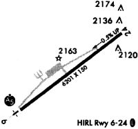
Runways
Runway Summary
| Runways: | 06/24 |
| Longest Runway: | 06/24 is 6201 ft (1890 m) long |
| Runways with an Instrument Approach: | 06 |
PSK Airport Runway Details
| Runway 06/24 | 6201 ft x 150 ft (1890 m x 46 m) | |
| Runway Length Source: | 3RD PARTY SURVEY as of 09/05/2021 | |
| Surface: | Asphalt - Good condition - Saw-cut or plastic grooved | |
| Runway Edge Lights: | High Intensity | |
Runway Weight Bearing Capacity (in thousands of pounds) |
||
| Dual Wheel Landing Gear: | 60.0 | |
Runway 06 |
Runway 24 |
|
Elevation: |
2104.5 | 2073.0 |
Latitude: |
37-07-55.5784N | 37-08-33.2413N |
Longitude: |
080-41-12.7343W | 080-40-12.3138W |
|
Runway True Alignment: |
052 | 232 |
ILS Type: |
ILS | |
Glide Path Angle: |
3.0 degrees | 3.0 degrees |
Traffic Pattern: |
Left | Left |
Runway Markings Type: |
Precision Instrument | Nonprecision Instrument |
Runway Markings Condition: |
Fair | Fair |
Object at End: |
TREES | |
Object Height: |
93 | |
Distance from End: |
2205 | |
Object Centerline Offset: |
531 ft. right of centerline | |
Visual Glide Slope Indicators: |
4-Light PAPI On Left Side Of Runway | 4-Light PAPI On Left Side Of Runway |
Approach Light System: |
1,400 Foot Medium Intensity Approach Lighting System With Runway Alignment Indicator Lights | |
REIL: |
Yes | |
Touchdown Lights: |
No | No |
Centerline Lights: |
No | No |
Threshold Crossing Height: |
58 | 44 |
Services
Airframe Repair: |
Major |
Powerplant Repair: |
Major |
Bottled Oxygen: |
None |
Bulk Oxygen: |
None |
Fuel Available: |
100LL |
Landing Fees: |
No |
Parking: |
Hangars and tiedowns available |
Maps & Diagrams
PSK Sectional
Flight Planning
at skyvector.com
at skyvector.com