Location
Latitude: |
40-50-12.9000N (40.836917) |
Longitude: |
076-33-08.8000W (-76.552444) |
Elevation: |
880.6 feet MSL (268 m MSL) |
Magnetic Variation: |
11.3 W (as of April 2024 from WMM2020 model) |
Time Zone: |
UTC -5.0 (Standard Time) UTC -4.0 (Daylight Savings Time) |
From City: |
03 N.M. N of Shamokin, Pennsylvania |
Found On: |
New York Chart |
FAA Region: |
AEA |
Contacts
Manager: |
Publicly owned: |
| RON SMITH PO BOX 94 PAXINOS, PA 17860 570-898-8588 |
NORTHUMBERLAND CO APT AUTH PO BOX 94 PAXINOS, PA 17860 570-898-8588 |
Operations
Airport Status: |
Operational |
Facility Use: |
Public |
Type: |
Airport |
Control tower: |
No |
Attendance (Months/Days/Hours): |
Months/Days/Hours ALL/MON-FRI/0800-1400 |
Boundary ARTCC: |
ZNY (New York) |
Responsible ARTCC: |
ZNY (New York) |
Lighting Schedule: |
SEE RMK |
Segmented Circle Indicator: |
No |
Traffic Pattern Altitude (MSL): |
1881 feet (573 m) |
NOTAMs Facility: |
IPT |
NOTAM-D Service: |
Yes |
International Airport of Entry: |
No |
Customs Landing Rights: |
No |
Military Landing Rights: |
Yes |
Civil/Military Joint Use: |
No |
Based Aircraft
| Single Engine: | 13 |
| Multi Engine: | 2 |
| GA Helicopters: | 1 |
Annual Operations (as of 02/21/2023)
| Total Operations: | 23150 | |
| GA Local: | 15000 | 64.8% |
| GA Itinerant: | 8000 | 34.6% |
| Military Aircraft: | 150 | 0.6% |
Communications
| CTAF: | 122.800 |
| Unicom: | 122.800 |
| Approach: | HARRISBURG 118.25 118.25 |
| Departure: | HARRISBURG 118.25 118.25 |
| AWOS-3: | 119.175 (570-672-0389) |
Fixed Based Operators (FBOs) & Fuel
(Click on a business for detail)
Please help us keep this information up to date. This is a FREE SERVICE just like everything else on Airport Guide! If you see that a business needs to be added, modified, or deleted please fill out our Update Form.
To add, modify, or delete a business click here.
Please help us keep this information up to date. This is a FREE SERVICE just like everything else on Airport Guide! If you see that a business needs to be added, modified, or deleted please fill out our Update Form.
Area Code: 570 |
| Business Name | Frequency | Phone | Fuel Grade |
|---|
Flight Service Stations
| Primary | Alternate | |
| FSS on Field: | N | |
| FSS Name (ID): | Williamsport(IPT) | |
| Frequency: | ||
| Toll Free Phone: | 1-800-WX-BRIEF |
Instrument Procedures / Charts
FAA Terminal Procedures valid from 0901Z 03/21/24 to 0901Z 04/18/24.
There are various types of charts available for an airport. They are listed in the Page Type column. Here is a legend for those types:
APD - Airport Diagram
DP - Departure Procedure Charts
HOT - Hot Spots
IAP - Instrument Approach Procedure Charts
MIN - Minimums
STAR - Standard Terminal Arrival Charts
| Page Type | Page Name | Volume | Action Since Last Cycle |
|---|---|---|---|
| IAP | RNAV (GPS) RWY 08 | NE-4 | |
| IAP | RNAV (GPS) RWY 26 | NE-4 | |
| IAP | VOR RWY 08 | NE-4 | |
| MIN | TAKEOFF MINIMUMS | NE-4 |
Terminal Procedures are only available for airports in several countries with more being added all the time. If you are looking for a specific country's charts, please send an email to support(at)airportguide.com stating the country name. This will be used to prioritize the implementation.
Navigation Aids (Navaids) near N79
| Dist (NM) | ID | Morse Code | Name | Type | Freq | True Hdg | Mag Hdg |
|---|---|---|---|---|---|---|---|
| 12.3 | MIP | _ _ . . . _ _ . | Milton | VORTAC | 109.20 | 335 | 346 |
| 15.3 | SEG | . . . . _ _ . | Selinsgrove | VOR-DME | 110.40 | 259 | 270 |
| 17.1 | RAV | . _ . . _ . . . _ | Ravine | VORTAC | 114.60 | 187 | 198 |
| 21.0 | HZL | . . . . _ _ . . . _ . . | Hazleton | VOR | 109.40 | 66 | 77 |
| 24.1 | BZJ | _ . . . _ _ . . . _ _ _ | Bellgrove | NDB | 328 | 180 | 191 |
| 27.4 | PIX | . _ _ . . . _ . . _ | Picture Rocks | NDB | 344 | 344 | 355 |
| 31.7 | FQM | . . _ . _ _ . _ _ _ | Williamsport | VOR-DME | 114.40 | 341 | 352 |
| 38.8 | MD | _ _ _ . . | Enola | NDB | 204 | 204 | 215 |
| 39.6 | MDT | _ _ _ . . _ | Harrisburg | VOT | 110.00 | 194 | 205 |
| 39.8 | HAR | . . . . . _ . _ . | Harrisburg | VORTAC | 112.50 | 216 | 227 |
| 42.4 | ETX | . _ _ . . _ | East Texas | VOR-DME | 110.20 | 110 | 122 |
| 44.6 | CX | _ . _ . _ . . _ | Latle | NDB | 219 | 207 | 218 |
| 44.6 | LRP | . _ . . . _ . . _ _ . | Lancaster | VOR-DME | 117.30 | 164 | 175 |
| 47.0 | LVZ | . _ . . . . . _ _ _ . . | Wilkes-Barre | VORTAC | 111.60 | 55 | 67 |
| 50.3 | FJC | . . _ . . _ _ _ _ . _ . | Allentown | VORTAC | 117.50 | 97 | 109 |
| 54.1 | UN | . . _ _ . | Penue | NDB | 388 | 275 | 286 |
| 57.0 | EUD | . . . _ _ . . | York | NDB | 254 | 195 | 206 |
| 58.4 | PTW | . _ _ . _ . _ _ | Pottstown | VORTAC | 116.50 | 128 | 140 |
| 61.7 | LHY | . _ . . . . . . _ . _ _ | Lake Henry | VORTAC | 110.80 | 51 | 63 |
| 62.3 | UKT | . . _ _ . _ _ | Quakertown | NDB | 208 | 112 | 124 |
Nearby Airports with Fuel
Notices to Airmen (NOTAMS)
Remarks
| A110-1 | FOR CD CTC HARRISBURG APCH AT 800-932-0712. |
| A13 | AFTER HOURS 570-898-8588 |
| A58-08 | RWY 08 TREES/BRUSH 165 L OF CNTRLN PARL TO RWY FROM THLD OUT TO 200 FT. |
| A81-APT | ACTVT PAPI RY 08/26; MIRL RY 08/26 - 121.8. |
| E111 | EXISTED PRIOR TO 1959. |
Runways
Runway Summary
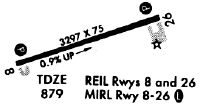
| Runways: | 08/26 |
| Longest Runway: | 08/26 is 3297 ft (1005 m) long |
| Runways with an Instrument Approach: |
N79 Airport Runway Details
| Runway 08/26 | 3297 ft x 75 ft (1005 m x 23 m) | |
| Surface: | Asphalt - Fair condition - No special surface treatment | |
| Runway Edge Lights: | Medium Intensity | |
Runway Weight Bearing Capacity (in thousands of pounds) |
||
| Single Wheel Landing Gear: | 12.5 | |
Runway 08 |
Runway 26 |
|
Elevation: |
852.5 | 880.5 |
Latitude: |
40-50-08.0035N | 40-50-17.8382N |
Longitude: |
076-33-29.2886W | 076-32-48.3967W |
|
Runway True Alignment: |
072 | 252 |
Glide Path Angle: |
3.0 degrees | 3.0 degrees |
Traffic Pattern: |
Left | Left |
Runway Markings Type: |
Nonprecision Instrument | Nonprecision Instrument |
Runway Markings Condition: |
Fair | Fair |
Object at End: |
TREES | |
Object Height: |
18 | |
Distance from End: |
395 | |
Object Centerline Offset: |
257 ft. left of centerline | |
Visual Glide Slope Indicators: |
2-Light PAPI On Left Side Of Runway | 2-Light PAPI On Left Side Of Runway |
REIL: |
Yes | Yes |
Threshold Crossing Height: |
40 | 40 |
Services
Airframe Repair: |
Minor |
Powerplant Repair: |
Minor |
Bottled Oxygen: |
None |
Bulk Oxygen: |
None |
Fuel Available: |
100LL, Jet A+ |
Landing Fees: |
No |
Parking: |
Tiedowns available |
Maps & Diagrams
N79 Sectional
Flight Planning
at skyvector.com
at skyvector.com