
Location
Latitude: |
25-46-42.5986N (25.7785) |
Longitude: |
100-06-25.2081W (-100.107002) |
Elevation: |
1278 feet MSL (390 m MSL) |
Magnetic Variation: |
4.4 E (as of April 2024 from WMM2020 model) |
Time Zone: |
UTC -6.0 (Standard Time) UTC -5.0 (Daylight Savings Time) |
Contacts
Manager: |
: |
Operations
Airport Status: |
Operational |
Facility Use: |
Public |
Type: |
Airport |
Traffic Pattern Altitude (MSL): |
2278 feet (694 m) |
Based Aircraft
Annual Operations (as of )
Communications
| MONTERREY TWR: | 118.1 |
| GND: | 121.9 |
| MONTERREY APP: | 119.75 |
| ATIS: | 127.7 |
Fixed Based Operators (FBOs) & Fuel
(Click on a business for detail)
Please help us keep this information up to date. This is a FREE SERVICE just like everything else on Airport Guide! If you see that a business needs to be added, modified, or deleted please fill out our Update Form.
To add, modify, or delete a business click here.
Please help us keep this information up to date. This is a FREE SERVICE just like everything else on Airport Guide! If you see that a business needs to be added, modified, or deleted please fill out our Update Form.
| Business Name | Frequency | Phone | Fuel Grade |
|---|
Flight Service Stations
| Primary | Alternate | |
| FSS on Field: | ||
| FSS Name (ID): | ||
| Frequency: | ||
| Toll Free Phone: |
Instrument Procedures / Charts
Terminal Procedures are only available for airports in several countries with more being added all the time. If you are looking for a specific country's charts, please send an email to support(at)airportguide.com stating the country name. This will be used to prioritize the implementation.
Navigation Aids (Navaids) near MTY
Nearby Airports with Fuel
| Dist (NM) | Name (Airport IDs) | True Hdg | Mag Hdg | Fuel Grade |
|---|---|---|---|---|
| 85.0 | Zapata County Airport (KAPY APY) |
32 | 28 | 100LL, Jet A |
Notices to Airmen (NOTAMS)
Remarks
No remarks for this landing facility
Runways
Services
Fuel Available: |
100LL, Jet A |
Parking: |
Hangars and tiedowns available |
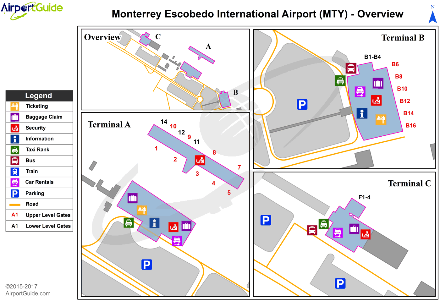
Maps & Diagrams
MTY Sectional
Flight Planning
at skyvector.com
at skyvector.com
