Location
Latitude: |
59-26-59.7970N (59.449944) |
Longitude: |
146-18-26.0660W (-146.307241) |
Elevation: |
100.4 feet MSL (31 m MSL) |
Magnetic Variation: |
15.9 E (as of April 2024 from WMM2020 model) |
Time Zone: |
UTC -9.0 (Standard Time) UTC -8.0 (Daylight Savings Time) |
From City: |
01 N.M. S of Middleton Island, Alaska |
Found On: |
Seward Chart |
FAA Region: |
AAL |
Contacts
Manager: |
Publicly owned: |
| US GOV, FAA KENAI SSC 427 N. WILLOW ST. KENAI, AK 99611 907-283-4526 |
FAA-KENAI SUPPORT CENTER 427 N. WILLOW ST. KENAI, AK 99611 907-283-4526 |
Operations
Airport Status: |
Operational |
Facility Use: |
Public |
Type: |
Airport |
Activation Date: |
01/1949 |
Control tower: |
No |
Attendance (Months/Days/Hours): |
Months/Days/Hours Unattended |
Boundary ARTCC: |
ZAN (Anchorage) |
Responsible ARTCC: |
ZAN (Anchorage) |
Segmented Circle Indicator: |
No |
Traffic Pattern Altitude (MSL): |
1100 feet (335 m) |
NOTAMs Facility: |
MDO |
NOTAM-D Service: |
Yes |
International Airport of Entry: |
No |
Customs Landing Rights: |
No |
Military Landing Rights: |
No |
Civil/Military Joint Use: |
No |
Based Aircraft
Annual Operations (as of 12/31/2022)
| Total Operations: | 150 | |
| Air Taxi: | 100 | 66.7% |
| GA Itinerant: | 50 | 33.3% |
Communications
| CTAF: | 122.900 |
| AWOS-3P: | 135.725 (907-424-7635) |
- APCH/DEP SVC PRVDD BY ANCHORAGE ARTCC ON FREQ 133.6/269.4 (MIDDLETON ISLAND RCAG).
- COMMUNICATIONS PRVDD BY JUNEAU FSS ON FREQ 122.05 (MIDDLETON ISLAND RCO).
Fixed Based Operators (FBOs) & Fuel
(Click on a business for detail)
Please help us keep this information up to date. This is a FREE SERVICE just like everything else on Airport Guide! If you see that a business needs to be added, modified, or deleted please fill out our Update Form.
To add, modify, or delete a business click here.
Please help us keep this information up to date. This is a FREE SERVICE just like everything else on Airport Guide! If you see that a business needs to be added, modified, or deleted please fill out our Update Form.
Area Code: 907 |
| Business Name | Frequency | Phone | Fuel Grade |
|---|
Flight Service Stations
| Primary | Alternate | |
| FSS on Field: | N | |
| FSS Name (ID): | Juneau(JNU) | |
| Frequency: | ||
| Toll Free Phone: | 1-866-297-2236 |
Instrument Procedures / Charts
FAA Terminal Procedures valid from 0901Z 03/21/24 to 0901Z 04/18/24.
There are various types of charts available for an airport. They are listed in the Page Type column. Here is a legend for those types:
APD - Airport Diagram
DP - Departure Procedure Charts
HOT - Hot Spots
IAP - Instrument Approach Procedure Charts
MIN - Minimums
STAR - Standard Terminal Arrival Charts
| Page Type | Page Name | Volume | Action Since Last Cycle |
|---|---|---|---|
| IAP | RNAV (GPS) RWY 02 | AK-1 | Changed |
| IAP | RNAV (GPS) RWY 20 | AK-1 | Changed |
| IAP | VOR RWY 02 | AK-1 | |
| MIN | TAKEOFF MINIMUMS | AK-1 |
Terminal Procedures are only available for airports in several countries with more being added all the time. If you are looking for a specific country's charts, please send an email to support(at)airportguide.com stating the country name. This will be used to prioritize the implementation.
Navigation Aids (Navaids) near MDO
| Dist (NM) | ID | Morse Code | Name | Type | Freq | True Hdg | Mag Hdg |
|---|---|---|---|---|---|---|---|
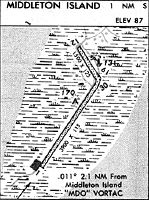
| 2.1 | MDO | _ _ _ . . _ _ _ | Middleton Island | VOR-DME | 115.30 | 217 | 201 |
| 62.4 | ALJ | . _ . _ . . . _ _ _ | Orca Bay | NDB | 233 | 352 | 336 |
| 62.5 | JOH | . _ _ _ _ _ _ . . . . | Johnstone Point | VOR-DME | 116.70 | 352 | 336 |
| 67.7 | GCR | _ _ . _ . _ . . _ . | Glacier River | NDB | 404 | 21 | 5 |
Nearby Airports with Fuel
| Dist (NM) | Name (Airport IDs) | True Hdg | Mag Hdg | Fuel Grade |
|---|---|---|---|---|
| 67.9 | Cordova Municipal Airport (CKU CKU) |
14 | 358 | 100LL |
Notices to Airmen (NOTAMS)
Remarks
| A110-1 | WX CAMERA AVBL ON INTERNET AT HTTPS://WEATHERCAMS.FAA.GOV |
| A110-4 | RWY 13/31 NOT MAINTAINED. BRUSH 2 FT HIGH RWY 31 APCH. GRASS AND ROCKS ON RWY. |
| A110-6 | EAGLE NEST ON APCH TO RWY 02. |
| A110-7 | WX CAMERA LOCATED ON RY EDGE. |
| A110-8 | ELECTRICAL TRANSFORMER LOCATED WITHIN SAFETY AREA AT THE APCH END OF RWY 02. BE ALERT: RABBITS AND WATERFOWL IN RWY AREA. |
| A30-02/20 | RWY 02/20 SLOPES DOWN TOWARD S END. SAFETY AREAS SOFT. |
| A30-13/31 | RWY 13/31 CLSD INDEFLY. |
| A42-02 | RWY 02/20 MARKED WITH RWY CONES. |
| A42-13 | 13/31 MKD WITH CONES & OTS LIGHTS. MANY MISSING. |
Runways
Runway Summary
| Runways: | 02/20 13/31 |
| Longest Runway: | 02/20 is 3158 ft (963 m) long |
| Runways with an Instrument Approach: |
MDO Airport Runway Details
| Runway 02/20 | 3158 ft x 115 ft (963 m x 35 m) | |
| Runway Length Source: | REGION as of 08/03/2004 | |
| Surface: | Gravel - Good condition - No special surface treatment | |
Runway 02 |
Runway 20 |
|
Elevation: |
100.1 | 100.4 |
Latitude: |
59-26-39.1511N | 59-27-04.8411N |
Longitude: |
146-18-46.2678W | 146-18-11.8447W |
|
Runway True Alignment: |
034 | 214 |
Glide Path Angle: |
0.0 degrees | 0.0 degrees |
Traffic Pattern: |
Left | Left |
Runway Markings Condition: |
Poor | Poor |
Object at End: |
ROAD | ROAD |
Object Height: |
15 | 15 |
Distance from End: |
0 | 0 |
Object Centerline Offset: |
94 ft. left of centerline | 84 ft. right of centerline |
| Runway 13/31 | 1500 ft x 125 ft (457 m x 38 m) | |
| Surface: | Gravel - Good condition - No special surface treatment | |
Runway 13 |
Runway 31 |
|
Elevation: |
98.9 | 96.8 |
Latitude: |
59-27-22.5940N | 59-27-09.8347N |
Longitude: |
146-18-27.0931W | 146-18-12.4533W |
|
Runway True Alignment: |
149 | 329 |
Glide Path Angle: |
0.0 degrees | 0.0 degrees |
Traffic Pattern: |
Left | Left |
Object at End: |
ROAD | ROAD |
Object Height: |
15 | 15 |
Distance from End: |
0 | 0 |
Object Centerline Offset: |
94 ft. left of centerline | 84 ft. right of centerline |
Services
Airframe Repair: |
Major |
Powerplant Repair: |
Major |
Bottled Oxygen: |
None |
Bulk Oxygen: |
None |
Fuel Available: |
100LL |
Landing Fees: |
No |
Parking: |
Tiedowns available |
Maps & Diagrams
MDO Sectional
Flight Planning
at skyvector.com
at skyvector.com