Location
Latitude: |
33-35-02.5000N (33.584028) |
Longitude: |
088-40-00.1000W (-88.666694) |
Elevation: |
205.2 feet MSL (63 m MSL) |
Magnetic Variation: |
2.6 W (as of April 2024 from WMM2020 model) |
Time Zone: |
UTC -6.0 (Standard Time) UTC -5.0 (Daylight Savings Time) |
From City: |
02 N.M. S of West Point, Mississippi |
Found On: |
Memphis Chart |
FAA Region: |
ASO |
Contacts
Manager: |
Publicly owned: |
| RANDY JONES PO BOX 1117 WEST POINT, MS 39773 662-524-0039 |
CITY OF WEST POINT 204 COMMERCE/BOX 1117 WEST POINT, MS 39773 662-494-2573 |
Operations
Airport Status: |
Operational |
Facility Use: |
Public |
Type: |
Airport |
Activation Date: |
08/1959 |
Control tower: |
No |
Attendance (Months/Days/Hours): |
Months/Days/Hours Unattended |
Boundary ARTCC: |
ZME (Memphis) |
Responsible ARTCC: |
ZME (Memphis) |
Lighting Schedule: |
SEE RMK |
Segmented Circle Indicator: |
Yes |
Traffic Pattern Altitude (MSL): |
1205 feet (367 m) |
NOTAMs Facility: |
GWO |
NOTAM-D Service: |
Yes |
International Airport of Entry: |
No |
Customs Landing Rights: |
No |
Military Landing Rights: |
Yes |
Civil/Military Joint Use: |
No |
Based Aircraft
| Single Engine: | 12 |
| Multi Engine: | 1 |
Annual Operations (as of 02/09/2023)
| Total Operations: | 8116 | |
| GA Local: | 4944 | 60.9% |
| GA Itinerant: | 2884 | 35.5% |
| Military Aircraft: | 288 | 3.5% |
Communications
| CTAF: | 122.900 |
| Approach: | COLUMBUS 135.6 135.6 MEMPHIS ARTCC |
| Departure: | COLUMBUS 135.6 135.6 MEMPHIS ARTCC |
- APCH/DEP SVC PRVDD BY MEMPHIS ARTCC (COLUMBUS RCAG) ON FREQS 127.1/269.4 WHEN COLUMBUS APCH CTL CLSD.
Fixed Based Operators (FBOs) & Fuel
(Click on a business for detail)
Please help us keep this information up to date. This is a FREE SERVICE just like everything else on Airport Guide! If you see that a business needs to be added, modified, or deleted please fill out our Update Form.
To add, modify, or delete a business click here.
Please help us keep this information up to date. This is a FREE SERVICE just like everything else on Airport Guide! If you see that a business needs to be added, modified, or deleted please fill out our Update Form.
Area Code: 662 |
| Business Name | Frequency | Phone | Fuel Grade |
|---|
Flight Service Stations
| Primary | Alternate | |
| FSS on Field: | N | |
| FSS Name (ID): | Greenwood(GWO) | |
| Frequency: | ||
| Toll Free Phone: | 1-800-WX-BRIEF |
Instrument Procedures / Charts
FAA Terminal Procedures valid from 0901Z 03/21/24 to 0901Z 04/18/24.
There are various types of charts available for an airport. They are listed in the Page Type column. Here is a legend for those types:
APD - Airport Diagram
DP - Departure Procedure Charts
HOT - Hot Spots
IAP - Instrument Approach Procedure Charts
MIN - Minimums
STAR - Standard Terminal Arrival Charts
| Page Type | Page Name | Volume | Action Since Last Cycle |
|---|---|---|---|
| IAP | RNAV (GPS) RWY 18 | SC-4 | |
| IAP | RNAV (GPS) RWY 36 | SC-4 | |
| IAP | VOR/DME-B | SC-4 | |
| MIN | TAKEOFF MINIMUMS | SC-4 |
Terminal Procedures are only available for airports in several countries with more being added all the time. If you are looking for a specific country's charts, please send an email to support(at)airportguide.com stating the country name. This will be used to prioritize the implementation.
Navigation Aids (Navaids) near M83
| Dist (NM) | ID | Morse Code | Name | Type | Freq | True Hdg | Mag Hdg |
|---|---|---|---|---|---|---|---|
| 9.7 | IGB | . . _ _ . _ . . . | Bigbee | VORTAC | 116.20 | 127 | 130 |
| 11.9 | CBM | _ . _ . _ . . . _ _ | Caledonia | VORTAC | 115.20 | 73 | 76 |
| 36.1 | TU | _ . . _ | Veron | NDB | 420 | 351 | 354 |
| 38.9 | OTB | _ _ _ _ _ . . . | Tupelo | VOR-DME | 109.80 | 350 | 353 |
| 49.2 | HAB | . . . . . _ _ . . . | Hamilton | DME | 110.4 | 41 | 44 |
| 56.1 | TC | _ _ . _ . | Tuske | NDB | 362 | 116 | 119 |
| 59.8 | LDK | . _ . . _ . . _ . _ | Crimson | TACAN | 117.80 | 108 | 111 |
| 60.7 | NMM | _ . _ _ _ _ | Meridian | TACAN | 111.90 | 174 | 177 |
| 63.0 | SBQ | . . . _ . . . _ _ . _ | Scobey | NDB | 245 | 287 | 289 |
| 67.7 | UV | . . _ . . . _ | Tunng | NDB | 426 | 315 | 317 |
| 70.9 | GW | _ _ . . _ _ | Teock | NDB | 349 | 270 | 272 |
| 72.7 | MEI | _ _ . . . | Meridian | VORTAC | 117.00 | 185 | 188 |
| 73.7 | EWA | . . _ _ . _ | Kewanee | DME | 113.8 | 171 | 174 |
| 73.9 | OKW | _ _ _ _ . _ . _ _ | Brookwood | VORTAC | 111.00 | 105 | 108 |
| 80.4 | ME | _ _ . | Savoy | NDB | 356 | 183 | 186 |
| 80.9 | SQS | . . . _ _ . _ . . . | Sidon | VORTAC | 114.70 | 265 | 267 |
| 82.2 | HLI | . . . . . _ . . . . | Holly Springs | VORTAC | 112.40 | 330 | 332 |
| 85.9 | UU | . . _ . . _ | Seyer | NDB | 334 | 1 | 4 |
| 88.4 | VUZ | . . . _ . . _ _ _ . . | Vulcan | VORTAC | 114.40 | 86 | 89 |
| 89.1 | MSL | _ _ . . . . _ . . | Muscle Shoals | DME | 116.25 | 40 | 43 |
Nearby Airports with Fuel
Notices to Airmen (NOTAMS)
Remarks
| A110-1 | COURTESY CAR AVBL. |
| A110-2 | FOR CD CTC COLUMBUS APCH AT 662-434-3044, WHEN CLSD CTC MEMPHIS ARTCC AT 901-368-8453/8449. |
| A54-36 | TREES. |
| A57-18 | APCH RATIO 24:1 FM DTHR. |
| A58-18 | RR 50 FT FM RWY END. |
| A58-36 | 4 FT FENCE 200 FT FM END OF RWY. |
| A70-FUEL-10 | 0LL FUEL SVC AVBL 24 HR WITH CREDIT CARD. |
| A75 | PILOTS MUST PRVD THEIR OWN TIEDOWN ROPES. |
| A81-APT | DUSK-2200. AFT 2200, ACTVT MIRL RWY 18/36 - CTAF. |
Runways
Runway Summary
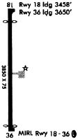
| Runways: | 18/36 |
| Longest Runway: | 18/36 is 3850 ft (1173 m) long |
| Runways with an Instrument Approach: |
M83 Airport Runway Details
| Runway 18/36 | 3850 ft x 75 ft (1173 m x 23 m) | |
| Runway Length Source: | 3RD PARTY SURVEY as of 12/09/2010 | |
| Surface: | Asphalt - Fair condition - No special surface treatment | |
| Runway Edge Lights: | Medium Intensity | |
Runway Weight Bearing Capacity (in thousands of pounds) |
||
| Single Wheel Landing Gear: | 30.0 | |
| Dual Wheel Landing Gear: | 36.0 | |
Runway 18 |
Runway 36 |
|
Elevation: |
205.2 | 203.8 |
Latitude: |
33-35-21.5545N | 33-34-43.4730N |
Longitude: |
088-39-59.9274W | 088-40-00.2631W |
|
Runway True Alignment: |
180 | 360 |
Glide Path Angle: |
0.0 degrees | 0.0 degrees |
Traffic Pattern: |
Left | Left |
Runway Markings Type: |
Nonprecision Instrument | Nonprecision Instrument |
Runway Markings Condition: |
Fair | Fair |
Object at End: |
TREE | ROAD |
Object Height: |
47 | 11 |
Distance from End: |
1400 | 900 |
Object Centerline Offset: |
100 ft. right of centerline | |
Threshold Elevation: |
203.5 | |
Displaced Threshold: |
390 | |
Threshold Latitude: |
33-35-17.6983N | |
Threshold Longitude: |
088-39-59.9528W |
Services
Bottled Oxygen: |
None |
Bulk Oxygen: |
None |
Fuel Available: |
100LL |
Landing Fees: |
No |
Parking: |
Tiedowns available |
Maps & Diagrams
M83 Sectional
Flight Planning
at skyvector.com
at skyvector.com