Location
Latitude: |
33-08-45.5580N (33.145988) |
Longitude: |
089-03-44.8140W (-89.062448) |
Elevation: |
574.5 feet MSL (175 m MSL) |
Magnetic Variation: |
2.3 W (as of April 2024 from WMM2020 model) |
Time Zone: |
UTC -6.0 (Standard Time) UTC -5.0 (Daylight Savings Time) |
From City: |
01 N.M. N of Louisville, Mississippi |
Found On: |
Memphis Chart |
FAA Region: |
ASO |
Contacts
Manager: |
Publicly owned: |
| BOBBY SMITH PO BOX 1022 LOUISVILLE, MS 39339 662-705-4212 |
LOUISVILLE CITY & WINSTON COUNTY 200 S CHURCH ST BOX 147 LOUISVILLE, MS 39339 662-773-9201 |
Operations
Airport Status: |
Operational |
Facility Use: |
Public |
Type: |
Airport |
Activation Date: |
04/1963 |
Control tower: |
No |
Attendance (Months/Days/Hours): |
Months/Days/Hours Unattended |
Boundary ARTCC: |
ZME (Memphis) |
Responsible ARTCC: |
ZME (Memphis) |
Lighting Schedule: |
SEE RMK |
Segmented Circle Indicator: |
Yes |
Traffic Pattern Altitude (MSL): |
1574 feet (480 m) |
NOTAMs Facility: |
GWO |
NOTAM-D Service: |
Yes |
International Airport of Entry: |
No |
Customs Landing Rights: |
No |
Military Landing Rights: |
Yes |
Civil/Military Joint Use: |
No |
Based Aircraft
| Single Engine: | 9 |
| Jet Engine: | 7 |
| GA Helicopters: | 3 |
Annual Operations (as of 03/08/2023)
| Total Operations: | 8716 | |
| Air Taxi: | 500 | 5.7% |
| GA Local: | 3018 | 34.6% |
| GA Itinerant: | 5198 | 59.6% |
Communications
| CTAF: | 122.700 |
| Unicom: | 122.700 |
| AWOS-3PT: | 118.325 |
- APCH/DEP SVC PRVDD BY MEMPHIS ARTCC ON FREQS 132.75/263.0 (LOUISVILLE RCAG).
Fixed Based Operators (FBOs) & Fuel
(Click on a business for detail)
Please help us keep this information up to date. This is a FREE SERVICE just like everything else on Airport Guide! If you see that a business needs to be added, modified, or deleted please fill out our Update Form.
To add, modify, or delete a business click here.
Please help us keep this information up to date. This is a FREE SERVICE just like everything else on Airport Guide! If you see that a business needs to be added, modified, or deleted please fill out our Update Form.
Area Code: 601 |
| Business Name | Frequency | Phone | Fuel Grade |
|---|
Flight Service Stations
| Primary | Alternate | |
| FSS on Field: | N | |
| FSS Name (ID): | Greenwood(GWO) | |
| Frequency: | ||
| Toll Free Phone: | 1-800-WX-BRIEF |
Instrument Procedures / Charts
FAA Terminal Procedures valid from 0901Z 03/21/24 to 0901Z 04/18/24.
There are various types of charts available for an airport. They are listed in the Page Type column. Here is a legend for those types:
APD - Airport Diagram
DP - Departure Procedure Charts
HOT - Hot Spots
IAP - Instrument Approach Procedure Charts
MIN - Minimums
STAR - Standard Terminal Arrival Charts
| Page Type | Page Name | Volume | Action Since Last Cycle |
|---|---|---|---|
| IAP | RNAV (GPS) RWY 17 | SC-4 | |
| IAP | RNAV (GPS) RWY 35 | SC-4 | |
| MIN | ALTERNATE MINIMUMS | SC-4 | |
| MIN | TAKEOFF MINIMUMS | SC-4 |
Terminal Procedures are only available for airports in several countries with more being added all the time. If you are looking for a specific country's charts, please send an email to support(at)airportguide.com stating the country name. This will be used to prioritize the implementation.
Navigation Aids (Navaids) near LMS
| Dist (NM) | ID | Morse Code | Name | Type | Freq | True Hdg | Mag Hdg |
|---|---|---|---|---|---|---|---|
| 34.2 | IGB | . . _ _ . _ . . . | Bigbee | VORTAC | 116.20 | 53 | 56 |
| 42.9 | NMM | _ . _ _ _ _ | Meridian | TACAN | 111.90 | 142 | 144 |
| 43.1 | CBM | _ . _ . _ . . . _ _ | Caledonia | VORTAC | 115.20 | 46 | 49 |
| 47.9 | MEI | _ _ . . . | Meridian | VORTAC | 117.00 | 164 | 166 |
| 55.8 | EWA | . . _ _ . _ | Kewanee | DME | 113.8 | 146 | 149 |
| 55.9 | ME | _ _ . | Savoy | NDB | 356 | 164 | 166 |
| 57.8 | GW | _ _ . . _ _ | Teock | NDB | 349 | 297 | 299 |
| 60.4 | SBQ | . . . _ . . . _ _ . _ | Scobey | NDB | 245 | 317 | 319 |
| 63.8 | TU | _ . . _ | Veron | NDB | 420 | 13 | 15 |
| 63.8 | SQS | . . . _ _ . _ . . . | Sidon | VORTAC | 114.70 | 287 | 289 |
| 66.0 | OTB | _ _ _ _ _ . . . | Tupelo | VOR-DME | 109.80 | 11 | 13 |
| 67.5 | MHZ | _ _ . . . . _ _ . . | Magnolia | VORTAC | 113.20 | 231 | 233 |
| 67.6 | JAN | . _ _ _ . _ _ . | Jackson | VORTAC | 112.60 | 235 | 237 |
| 69.1 | JA | . _ _ _ . _ | Allen | NDB | 365 | 230 | 232 |
| 69.9 | TC | _ _ . _ . | Tuske | NDB | 362 | 89 | 92 |
| 71.2 | JAN | . _ _ _ . _ _ . | Jackson | VOT | 111.00 | 225 | 227 |
| 74.8 | JH | . _ _ _ . . . . | Brenz | NDB | 260 | 234 | 236 |
| 76.9 | LDK | . _ . . _ . . _ . _ | Crimson | TACAN | 117.80 | 84 | 87 |
| 79.5 | UV | . . _ . . . _ | Tunng | NDB | 426 | 339 | 341 |
| 82.1 | HAB | . . . . . _ _ . . . | Hamilton | DME | 110.4 | 39 | 42 |
Nearby Airports with Fuel
Notices to Airmen (NOTAMS)
Remarks
| A110-1 | FOR CD CTC MEMPHIS ARTCC AT 901-368-8453/8449. |
| A110-2 | COURTESY CAR AVBL. |
| A17 | FOR SVC CTC AMGR. |
| A70-FUEL-10 | 0LL FUEL AVBL 24 HRS WITH CREDIT CARD. ASSISTED SVC AVBL. |
| A81-APT | ACTVT MIRL RWY 17/35 - CTAF. PAPI RWY 17 & 35 OPR CONSLY. |
| A82 | AUTOMATED UNICOM; 4 CLICKS WX ADZY. |
Runways
Runway Summary
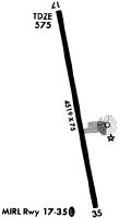
| Runways: | 17/35 |
| Longest Runway: | 17/35 is 4669 ft (1423 m) long |
| Runways with an Instrument Approach: |
LMS Airport Runway Details
| Runway 17/35 | 4669 ft x 75 ft (1423 m x 23 m) | |
| Runway Length Source: | 3RD PARTY SURVEY as of 04/17/2021 | |
| Surface: | Asphalt - Excellent condition - Saw-cut or plastic grooved | |
| Runway Edge Lights: | Medium Intensity | |
Runway Weight Bearing Capacity (in thousands of pounds) |
||
| Single Wheel Landing Gear: | 50.0 | |
Runway 17 |
Runway 35 |
|
Elevation: |
549.0 | 571.7 |
Latitude: |
33-09-08.3030N | 33-08-22.8121N |
Longitude: |
089-03-49.5898W | 089-03-40.0398W |
|
Runway True Alignment: |
170 | 350 |
Glide Path Angle: |
3.2 degrees | 3.0 degrees |
Traffic Pattern: |
Left | Left |
Runway Markings Type: |
Nonprecision Instrument | Nonprecision Instrument |
Runway Markings Condition: |
Good | Good |
Object at End: |
TREES | TREES |
Object Height: |
41 | 50 |
Distance from End: |
1200 | 1200 |
Object Centerline Offset: |
0 ft. left and right of centerline | 200 ft. left of centerline |
Visual Glide Slope Indicators: |
2-Light PAPI On Left Side Of Runway | 2-Light PAPI On Left Side Of Runway |
Threshold Crossing Height: |
48 | 40 |
Services
Bottled Oxygen: |
None |
Bulk Oxygen: |
None |
Fuel Available: |
100LL |
Landing Fees: |
No |
Parking: |
Hangars and tiedowns available |
Maps & Diagrams
LMS Sectional
Flight Planning
at skyvector.com
at skyvector.com