
Location
Latitude: |
42-46-43.1000N (42.778639) |
Longitude: |
084-35-10.3000W (-84.586194) |
Elevation: |
860.8 feet MSL (262 m MSL) |
Magnetic Variation: |
6.5 W (as of April 2024 from WMM2020 model) |
Time Zone: |
UTC -5.0 (Standard Time) UTC -4.0 (Daylight Savings Time) |
From City: |
03 N.M. NW of Lansing, Michigan |
Found On: |
Detroit Chart |
FAA Region: |
AGL |
Contacts
Manager: |
Publicly owned: |
| NICOLE NOLL-WILLIAMS 4100 CAPITOL CITY BLVD LANSING, MI 48906-2170 517-886-3711 |
CAPITAL REGION ARPT AUTHORITY 4100 CAPITOL CITY BLVD STE 19 LANSING, MI 48906-2183 517-321-6121 |
Operations
Airport Status: |
Operational |
Facility Use: |
Public |
Type: |
Airport |
Activation Date: |
04/1940 |
Control tower: |
Yes |
Attendance (Months/Days/Hours): |
Months/Days/Hours ALL/ALL/ALL |
Boundary ARTCC: |
ZOB (Cleveland) |
Responsible ARTCC: |
ZOB (Cleveland) |
Lighting Schedule: |
SS-SR |
Segmented Circle Indicator: |
No |
Traffic Pattern Altitude (MSL): |
1861 feet (567 m) |
NOTAMs Facility: |
LAN |
NOTAM-D Service: |
Yes |
International Airport of Entry: |
No |
Customs Landing Rights: |
No |
Military Landing Rights: |
Yes |
Civil/Military Joint Use: |
No |
Aircraft Rescue and Firefighting: |
Class I ARFF Index: B Air Carrier Service: Scheduled Certification Date: 11/2005 |
Based Aircraft
| Single Engine: | 32 |
| Multi Engine: | 17 |
| Jet Engine: | 12 |
| GA Helicopters: | 4 |
Annual Operations (as of 12/31/2022)
| Total Operations: | 28464 | |
| Commercial: | 2156 | 7.6% |
| Air Taxi: | 11001 | 38.6% |
| GA Local: | 3312 | 11.6% |
| GA Itinerant: | 11415 | 40.1% |
| Military Aircraft: | 580 | 2.0% |
Communications
| Unicom: | 122.950 |
| Tower: | LANSING 119.9 240.9 Hrs: 24 |
| Clearance Del.: | 123.675 |
| Ground: | 121.9 |
| Approach: | GREAT LAKES 118.65 118.65 118.65 118.65 CLEVELAND ARTCC |
| Departure: | GREAT LAKES 118.65 118.65 118.65 118.65 CLEVELAND ARTCC |
| ATIS: | 119.75 Hrs: 24 |
| ASOS: | (517-908-8494) |
| EMERG: | 121.5 |
- APCH/DEP SVC PRVDD BY CLEVELAND ARTCC (ZOB) ON FREQS 126.75/348.75 (FLINT RCAG) WHEN GREAT LAKES APCH CTL CLSD.
Fixed Based Operators (FBOs) & Fuel
(Click on a business for detail)
Please help us keep this information up to date. This is a FREE SERVICE just like everything else on Airport Guide! If you see that a business needs to be added, modified, or deleted please fill out our Update Form.
To add, modify, or delete a business click here.
Please help us keep this information up to date. This is a FREE SERVICE just like everything else on Airport Guide! If you see that a business needs to be added, modified, or deleted please fill out our Update Form.
Area Code: 517 |
| Business Name | Frequency | Phone | Fuel Grade |
|---|---|---|---|
| AvFlight Lansing
Website Update FBO info |
Unicom 122.95 | 517-321-7000 | 100LL, Jet A |

|
AvFuel |
100LL - 7.19 USD per gallon on 03/29/2024 |
Trucks AVFUEL CONTRACT/ AVTRIP POINTS WITH FUEL PURCHASE |
|
|
AvFuel |
Jet A - 7.20 USD per gallon on 04/01/2024 |
Trucks AVFUEL CONTRACT/ AVTRIP POINTS WITH FUEL PURCHASE |
|
|
AvFuel |
Jet A - 7.34 USD per gallon on 04/01/2024 |
Pumps requiring line service with additives |
| Gourmet Airfare
Website Update FBO info |
866-JET-FOOD (538-3663) | ||
| Superior Aviation, Inc.
Update FBO info |
Unicom 122.95 | 321-0224, 800-882-7751 | 100LL, Mogas, Jet A |
Flight Service Stations
| Primary | Alternate | |
| FSS on Field: | N | |
| FSS Name (ID): | Lansing(LAN) | |
| Frequency: | ||
| Toll Free Phone: | 1-800-WX-BRIEF |
Instrument Procedures / Charts
FAA Terminal Procedures valid from 0901Z 03/21/24 to 0901Z 04/18/24.
There are various types of charts available for an airport. They are listed in the Page Type column. Here is a legend for those types:
APD - Airport Diagram
DP - Departure Procedure Charts
HOT - Hot Spots
IAP - Instrument Approach Procedure Charts
MIN - Minimums
STAR - Standard Terminal Arrival Charts
| Page Type | Page Name | Volume | Action Since Last Cycle |
|---|---|---|---|
| APD | AIRPORT DIAGRAM | EC-1 | Changed |
| HOT | HOT SPOT | EC-1 | |
| IAP | ILS OR LOC RWY 10R | EC-1 | Changed |
| IAP | ILS OR LOC RWY 28L | EC-1 | Changed |
| IAP | RNAV (GPS) RWY 06 | EC-1 | Changed |
| IAP | RNAV (GPS) RWY 10R | EC-1 | Changed |
| IAP | RNAV (GPS) RWY 24 | EC-1 | Changed |
| IAP | RNAV (GPS) RWY 28L | EC-1 | Changed |
| MIN | ALTERNATE MINIMUMS | EC-1 | |
| MIN | TAKEOFF MINIMUMS | EC-1 |
Terminal Procedures are only available for airports in several countries with more being added all the time. If you are looking for a specific country's charts, please send an email to support(at)airportguide.com stating the country name. This will be used to prioritize the implementation.
Navigation Aids (Navaids) near LAN
| Dist (NM) | ID | Morse Code | Name | Type | Freq | True Hdg | Mag Hdg |
|---|---|---|---|---|---|---|---|
| 6.1 | LAN | . _ . . . _ _ . | Lansing | DME | 110.8 | 233 | 239 |
| 28.0 | OZW | _ _ _ _ _ . . . _ _ | Howell | NDB | 243 | 107 | 114 |
| 29.3 | JX | . _ _ _ _ . . _ | Jakso | NDB | 212 | 160 | 167 |
| 31.7 | JXN | . _ _ _ _ . . _ _ . | Jackson | DME | 115.45 | 169 | 176 |
| 32.7 | FN | . . _ . _ . | Petli | NDB | 269 | 69 | 76 |
| 35.6 | GR | _ _ . . _ . | Knobs | NDB | 263 | 281 | 287 |
| 36.4 | BT | _ . . . _ | Batol | NDB | 272 | 226 | 232 |
| 38.6 | FNT | . . _ . _ . _ | Flint | VORTAC | 116.90 | 72 | 79 |
| 40.1 | VIO | . . . _ . . _ _ _ | Victory | VOR-DME | 115.95 | 271 | 277 |
| 40.7 | BTL | _ . . . _ . _ . . | Battle Creek | VORTAC | 109.40 | 226 | 232 |
| 43.7 | LFD | . _ . . . . _ . _ . . | Litchfield | VOR-DME | 111.20 | 190 | 196 |
| 44.7 | MB | _ _ _ . . . | Olste | NDB | 257 | 23 | 30 |
| 46.7 | PSI | . _ _ . . . . . . | Pontiac | DME | 111 | 95 | 102 |
| 49.1 | SVM | . . . . . . _ _ _ | Salem | VORTAC | 114.30 | 116 | 123 |
| 50.4 | MBS | _ _ _ . . . . . . | Saginaw | VOR-DME | 112.90 | 26 | 33 |
| 51.1 | MOP | _ _ _ _ _ . _ _ . | Mount Pleasant | VOR-DME | 110.60 | 352 | 359 |
| 53.7 | AZO | . _ _ _ . . _ _ _ | Kalamazoo | DME | 109 | 233 | 239 |
| 54.4 | TCU | _ _ . _ . . . _ | Tecumseh | NDB | 239 | 145 | 152 |
| 57.0 | AZ | . _ _ _ . . | Austn | NDB | 371 | 227 | 233 |
| 57.3 | YIP | _ . _ _ . . . _ _ . | Willow Run | VOT | 108.85 | 124 | 131 |
Nearby Airports with Fuel
Notices to Airmen (NOTAMS)
Remarks
| A110-1 | BIRDS ON & INVOF ARPT. |
| A110-10 | TWY C SW OF TRANSIENT RAMP NOT AVBL TO ACFT WITH WINGSPAN 90 FT OR GTR. |
| A110-11 | TWY G NOT AVBL TO ACFT WITH WINGSPAN 94 FT OR GREATER. |
| A110-12 | RWY 6/24 AVBL TO ACR ACFT FOR TAXI ONLY. |
| A110-14 | TWYS E AND L NOT AVBL TO ACR ACFT. |
| A110-15 | RWY 10L/28R CLSD DLY SS-SR. |
| A110-16 | WIDE BODY ACFT USE TWYS B OR B1 WHEN EXITING RWY 10R-28L. WIDE BODY ACFT SHOULD USE TWY D WHEN ACESNG THE TRML RAMP. |
| A110-17 | PPR FOR ACFT WITH WINGSPAN GTR THAN 170 FT CTC ARPT OPS AT 517-321-8525. |
| A110-18 | PAEW ADJ TO MOV AREAS FOR GRASS MOWING OPS APR-NOV. |
| A110-4 | RWY 06/24 300 FT SAFETY AREA EACH END. |
| A110-6 | INTL ARRIVALS ACCEPTED UP TO 200 PAX. PLEASE CTC CBP FIS AT 517-327-1052 FOR ADDNL INFO. |
| A110-8 | USDOT EMERG CONTINGENCY PLAN ON FILE WITH THE ARPT OPS. PLEASE CTC OPS AT 517-321-8525 FOR ADDNL INFO. |
| A26 | ARFF INDEX C/D AVBL ON REQ CTC ARPT OPS AT 517-321-8525. |
| A30-06/24 | CLSD TO SKEDD ACR OPS GTR THAN 9 PAX SEATS OR UNSKED ACR OPS GTR THAN 30 PAX SEATS. |
| A30-10L/28R | CLSD TO SKEDD ACR OPS GTR THAN 9 PAX SEATS OR UNSKED ACR OPS GTR THAN 30 PAX SEATS. |
| A70-FUEL-10 | 0LL 100LL VIA TRUCK ONLY. SELF-SVC NOT AVBL. |
| E111 | DTRMN PENDING. |
| E80 | US CUSTOMS USER FEE ARPT. |
Runways
Runway Summary
| Runways: | 06/24 10L/28R 10R/28L |
| Longest Runway: | 10R/28L is 8506 ft (2593 m) long |
| Runways with an Instrument Approach: | 10R, 28L |
LAN Airport Runway Details
| Runway 06/24 | 5003 ft x 120 ft (1525 m x 37 m) | |
| Runway Length Source: | 3RD PARTY SURVEY as of 11/22/2015 | |
| Surface: | Asphalt - Fair condition - Saw-cut or plastic grooved | |
| Runway Pavement Class: | 45 /R/C/X/T | |
| Runway Edge Lights: | Medium Intensity | |
Runway Weight Bearing Capacity (in thousands of pounds) |
||
| Single Wheel Landing Gear: | 45.0 | |
| Dual Wheel Landing Gear: | 65.0 | |
| Dual Tandem Wheel Landing Gear: | 100.0 | |
Runway 06 |
Runway 24 |
|
Elevation: |
858.5 | 847.8 |
Latitude: |
42-46-23.4022N | 42-46-53.1229N |
Longitude: |
084-36-03.7633W | 084-35-10.1708W |
|
Runway True Alignment: |
053 | 233 |
Glide Path Angle: |
3.0 degrees | 3.0 degrees |
Traffic Pattern: |
Left | Left |
Runway Markings Type: |
Nonprecision Instrument | Nonprecision Instrument |
Runway Markings Condition: |
Good | Good |
Object at End: |
TREE | TREES |
Object Height: |
42 | 82 |
Distance from End: |
950 | 2819 |
Object Centerline Offset: |
300 ft. right of centerline | 417 ft. right of centerline |
Visual Glide Slope Indicators: |
4-Light PAPI On Left Side Of Runway | 4-Light PAPI On Left Side Of Runway |
REIL: |
Yes | Yes |
Touchdown Lights: |
No | No |
Centerline Lights: |
No | No |
Threshold Crossing Height: |
40 | 42 |
Declared Distances |
||
Take Off Run Avbl. (TORA): |
5002 | 5002 |
Take Off Distance Avbl. (TODA): |
5002 | 5002 |
Actual Stop Dist. Avbl. (ASDA): |
5002 | 5002 |
Landing Dist. Avbl. (LDA): |
5002 | 5002 |
| Runway 10L/28R | 3601 ft x 75 ft (1098 m x 23 m) | |
| Runway Length Source: | 3RD PARTY SURVEY as of 11/22/2015 | |
| Surface: | Asphalt - Fair condition - No special surface treatment | |
| Runway Pavement Class: | 70 /F/B/Y/U | |
Runway Weight Bearing Capacity (in thousands of pounds) |
||
| Single Wheel Landing Gear: | 12.0 | |
Runway 10L |
Runway 28R |
|
Elevation: |
845.7 | 850.4 |
Latitude: |
42-46-54.9125N | 42-46-54.5227N |
Longitude: |
084-35-05.9108W | 084-34-17.6269W |
|
Runway True Alignment: |
091 | 271 |
Glide Path Angle: |
0.0 degrees | 0.0 degrees |
Traffic Pattern: |
Left | Left |
Runway Markings Type: |
Basic | Basic |
Runway Markings Condition: |
Fair | Fair |
Object at End: |
TREES | ROAD |
Object Height: |
77 | 18 |
Distance from End: |
2208 | 551 |
Object Centerline Offset: |
300 ft. right of centerline | 417 ft. right of centerline |
REIL: |
No | No |
Touchdown Lights: |
No | No |
Centerline Lights: |
No | No |
Declared Distances |
||
Take Off Run Avbl. (TORA): |
3601 | 3601 |
Take Off Distance Avbl. (TODA): |
3601 | 3601 |
Actual Stop Dist. Avbl. (ASDA): |
3601 | 3601 |
Landing Dist. Avbl. (LDA): |
3601 | 3601 |
| Runway 10R/28L | 8506 ft x 150 ft (2593 m x 46 m) | |
| Runway Length Source: | 3RD PARTY SURVEY as of 11/22/2015 | |
| Surface: | Asphalt - Fair condition - Saw-cut or plastic grooved | |
| Runway Pavement Class: | 90 /R/B/W/T | |
| Runway Edge Lights: | High Intensity | |
Runway Weight Bearing Capacity (in thousands of pounds) |
||
| Single Wheel Landing Gear: | 100.0 | |
| Dual Wheel Landing Gear: | 175.0 | |
| Dual Tandem Wheel Landing Gear: | 300.0 | |
Runway 10R |
Runway 28L |
|
Elevation: |
860.4 | 848.2 |
Latitude: |
42-46-41.5315N | 42-46-40.6352N |
Longitude: |
084-36-03.7957W | 084-34-09.7508W |
|
Runway True Alignment: |
091 | 271 |
ILS Type: |
ILS | ILS/DME |
Glide Path Angle: |
3.0 degrees | 3.0 degrees |
Traffic Pattern: |
Left | Left |
Runway Markings Type: |
Precision Instrument | Precision Instrument |
Runway Markings Condition: |
Good | Good |
Object Centerline Offset: |
300 ft. right of centerline | 417 ft. right of centerline |
Visual Glide Slope Indicators: |
4-Light PAPI On Left Side Of Runway | 4-Light PAPI On Right Side Of Runway |
Runway Visual Range (RVR): |
Touchdown, Rollout | Touchdown, Rollout |
Approach Light System: |
1,400 Foot Medium Intensity Approach Lighting System With Runway Alignment Indicator Lights | 1,400 Foot Medium Intensity Approach Lighting System With Runway Alignment Indicator Lights |
REIL: |
No | No |
Touchdown Lights: |
No | No |
Centerline Lights: |
No | No |
Threshold Crossing Height: |
73 | 53 |
Declared Distances |
||
Take Off Run Avbl. (TORA): |
8506 | 8506 |
Take Off Distance Avbl. (TODA): |
8506 | 8506 |
Actual Stop Dist. Avbl. (ASDA): |
8506 | 8506 |
Landing Dist. Avbl. (LDA): |
8506 | 8506 |
Services
Airframe Repair: |
Major |
Powerplant Repair: |
Major |
Bottled Oxygen: |
High Pressure / Low Pressure |
Bulk Oxygen: |
High Pressure / Low Pressure |
Fuel Available: |
100LL, Jet A+ |
Parking: |
Hangars and tiedowns available |
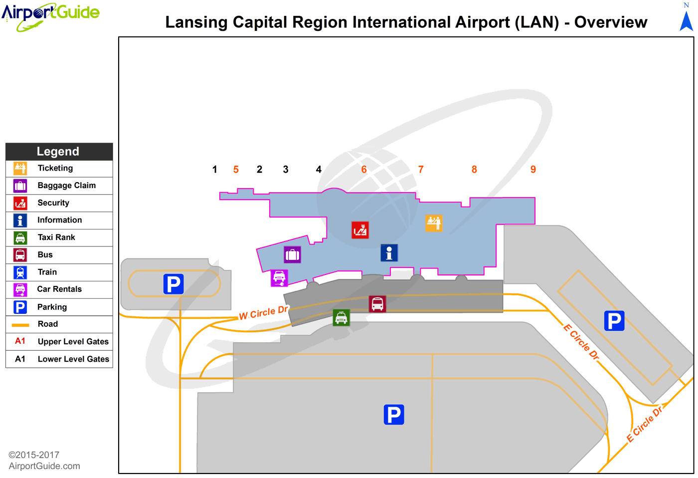
Maps & Diagrams
LAN Sectional
Flight Planning
at skyvector.com
at skyvector.com
 Diagram")