Location
Latitude: |
41-58-32.9856N (41.975829) |
Longitude: |
114-39-28.8567W (-114.658016) |
Elevation: |
5224.1 feet MSL (1592 m MSL) |
Magnetic Variation: |
12.1 E (as of April 2024 from WMM2020 model) |
Time Zone: |
UTC -8.0 (Standard Time) UTC -7.0 (Daylight Savings Time) |
From City: |
00 N.M. E of Jackpot, Nevada |
Found On: |
Salt Lake City Chart |
FAA Region: |
AWP |
Contacts
Manager: |
Publicly owned: |
| SHAWN BURT AIRPORT MANAGER, PO BOX 337 JACKPOT, NV 89825 775-755-2447 |
ELKO COUNTY 540 COURT STREET, SUITE 104 ELKO, NV 89801 775-738-6816 |
Operations
Airport Status: |
Operational |
Facility Use: |
Public |
Type: |
Airport |
Activation Date: |
08/1962 |
Control tower: |
No |
Attendance (Months/Days/Hours): |
Months/Days/Hours ON CALL |
Boundary ARTCC: |
ZLC (Salt Lake City) |
Responsible ARTCC: |
ZLC (Salt Lake City) |
Lighting Schedule: |
SEE RMK |
Segmented Circle Indicator: |
Yes |
Traffic Pattern Altitude (MSL): |
6224 feet (1897 m) |
NOTAMs Facility: |
RNO |
NOTAM-D Service: |
Yes |
International Airport of Entry: |
No |
Customs Landing Rights: |
No |
Military Landing Rights: |
Yes |
Civil/Military Joint Use: |
No |
Based Aircraft
Annual Operations (as of 05/31/2023)
| Total Operations: | 4000 | |
| GA Local: | 380 | 9.5% |
| GA Itinerant: | 2900 | 72.5% |
| Military Aircraft: | 720 | 18.0% |
Communications
| CTAF: | 122.800 |
| Unicom: | 122.800 |
| AWOS-AV: | 120.00 (775-755-2297) |
Fixed Based Operators (FBOs) & Fuel
(Click on a business for detail)
Please help us keep this information up to date. This is a FREE SERVICE just like everything else on Airport Guide! If you see that a business needs to be added, modified, or deleted please fill out our Update Form.
To add, modify, or delete a business click here.
Please help us keep this information up to date. This is a FREE SERVICE just like everything else on Airport Guide! If you see that a business needs to be added, modified, or deleted please fill out our Update Form.
Area Code: 775 |
| Business Name | Frequency | Phone | Fuel Grade |
|---|---|---|---|
| Cactus Pete's Casino
Update FBO info |
Unicom 122.8 | 755-2321 | 100LL |
Flight Service Stations
| Primary | Alternate | |
| FSS on Field: | N | |
| FSS Name (ID): | Reno(RNO) | |
| Frequency: | ||
| Toll Free Phone: | 1-800-WX-BRIEF |
Instrument Procedures / Charts
Terminal Procedures are only available for airports in several countries with more being added all the time. If you are looking for a specific country's charts, please send an email to support(at)airportguide.com stating the country name. This will be used to prioritize the implementation.
Navigation Aids (Navaids) near KPT
| Dist (NM) | ID | Morse Code | Name | Type | Freq | True Hdg | Mag Hdg |
|---|---|---|---|---|---|---|---|
| 31.2 | TWF | _ . _ _ . . _ . | Twin Falls | VORTAC | 113.10 | 13 | 1 |
| 33.0 | TW | _ . _ _ | Strik | NDB | 389 | 23 | 11 |
| 50.5 | BYI | _ . . . _ . _ _ . . | Burley | VOR-DME | 114.10 | 43 | 31 |
| 51.9 | LWL | . _ . . . _ _ . _ . . | Wells | VOR-DME | 114.65 | 196 | 184 |
| 51.9 | LCU | . _ . . _ . _ . . . _ | Lucin | VORTAC | 113.60 | 134 | 122 |
| 56.4 | HDG | . . . . _ . . _ _ . | Steelhead | NDB | 211 | 359 | 347 |
| 78.0 | LIA | . _ . . . . . _ | Liberator | VOR | 114.90 | 321 | 309 |
| 81.3 | STI | . . . _ . . | Sturgeon | NDB | 333 | 327 | 315 |
| 83.3 | HLE | . . . . . _ . . . | Hailey | NDB-DME | 220 | 12 | 360 |
| 83.5 | MUO | _ _ . . _ _ _ _ | Mountain Home | TACAN | 114.00 | 320 | 308 |
| 85.3 | BVL | _ . . . . . . _ . _ . . | Bonneville | VORTAC | 112.30 | 151 | 139 |
| 88.3 | BQU | _ . . . _ _ . _ . . _ | Bullion | VOR-DME | 115.85 | 214 | 202 |
| 99.2 | MLD | _ _ . _ . . _ . . | Malad City | VOR-DME | 117.40 | 81 | 69 |
Nearby Airports with Fuel
| Dist (NM) | Name (Airport IDs) | True Hdg | Mag Hdg | Fuel Grade |
|---|---|---|---|---|
| 31.3 | Joslin Field/Magic Valley Regional Airport (TWF KTWF TWF) |
13 | 1 | 100LL, Jet A-1+ |
| 37.8 | Buhl Municipal Airport (U03) |
350 | 338 | 100LL, MOGAS |
| 45.9 | Jerome County Airport (KJER JER) |
11 | 359 | 100LL, Jet A, Jet A+ |
| 52.0 | Burley Municipal Airport (BYI KBYI BYI) |
48 | 36 | 100LL, Jet A |
| 52.9 | Wells Municipal/Harriet Field Airport (LWL KLWL LWL) |
193 | 181 | 100LL, Jet A |
| 56.7 | Gooding Municipal Airport (GNG KGNG GNG) |
355 | 343 | 100LL, Jet A |
| 80.6 | Wendover Airport (ENV KENV ENV) |
159 | 147 | 100, Jet A |
| 85.8 | Elko Regional Airport (EKO KEKO EKO) |
216 | 204 | 100LL, Jet A |
| 93.1 | Friedman Meml Airport (SUN KSUN SUN) |
9 | 357 | 100LL, Jet A-1+ |
| 95.0 | American Falls Airport (U01) |
58 | 46 | 100LL |
Notices to Airmen (NOTAMS)
Remarks
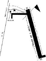
| A110-1 | TERRAIN OBSTNS LCTD S & W OF ARPT. |
| A110-2 | BIRD HAZARD EAST OF ARPT AT PONDS. |
| A110-4 | FUEL NOT AVBL. |
| A110-5 | EMERGENCY CONTACT 208-731-2447 |
| A110-6 | IN NO WIND CONDS, RCMD DEP RWY 15, ARR RWY 33 FOR SLOPE. |
| A81-APT | ACTVT REIL RWY 15 & 33; PAPI RWY 15 & 33; MIRL RWY 15/33 - CTAF. |
| A81-BCN | SS-SR. BCN VIS LTD FM WEST. |
Runways
Runway Summary
| Runways: | 15/33 |
| Longest Runway: | 15/33 is 6183 ft (1885 m) long |
| Runways with an Instrument Approach: |
KPT Airport Runway Details
| Runway 15/33 | 6183 ft x 60 ft (1885 m x 18 m) | |
| Runway Length Source: | 3RD PARTY SURVEY as of 10/12/2011 | |
| Surface: | Asphalt - Fair condition - No special surface treatment | |
| Runway Edge Lights: | Medium Intensity | |
Runway Weight Bearing Capacity (in thousands of pounds) |
||
| Single Wheel Landing Gear: | 12.5 | |
Runway 15 |
Runway 33 |
|
Elevation: |
5224.1 | 5174.9 |
Latitude: |
41-59-02.2354N | 41-58-03.7357N |
Longitude: |
114-39-40.5797W | 114-39-17.1337W |
Glide Path Angle: |
4.0 degrees | 3.5 degrees |
Traffic Pattern: |
Left | Left |
Runway Markings Type: |
Nonprecision Instrument | Nonprecision Instrument |
Runway Markings Condition: |
Good | Good |
Object at End: |
TREES | HILL |
Object Height: |
54 | 200 |
Object Marked/Lighted?: |
Lighted | |
Distance from End: |
1800 | 5000 |
Object Centerline Offset: |
100 ft. left of centerline | 0 ft. left and right of centerline |
Visual Glide Slope Indicators: |
2-Light PAPI On Left Side Of Runway | 2-Light PAPI On Left Side Of Runway |
REIL: |
Yes | Yes |
Touchdown Lights: |
No | No |
Centerline Lights: |
No | No |
Threshold Crossing Height: |
40 | 40 |
Services
Airframe Repair: |
None |
Powerplant Repair: |
None |
Bottled Oxygen: |
None |
Bulk Oxygen: |
None |
Fuel Available: |
100LL |
Landing Fees: |
No |
Parking: |
Tiedowns available |
Maps & Diagrams
KPT Sectional
Flight Planning
at skyvector.com
at skyvector.com