Location
Latitude: |
61-32-09.5000N (61.535972) |
Longitude: |
160-20-44.1000W (-160.345583) |
Elevation: |
63.3 feet MSL (19 m MSL) |
Magnetic Variation: |
10.5 E (as of April 2024 from WMM2020 model) |
Time Zone: |
UTC -9.0 (Standard Time) UTC -8.0 (Daylight Savings Time) |
From City: |
01 N.M. W of Kalskag, Alaska |
Found On: |
Mc Grath Chart |
FAA Region: |
AAL |
Contacts
Manager: |
Publicly owned: |
| ROXANNE EVAN PO BOX 73 ANIAK, AK 99552 907-675-4345 |
ALASKA DOT&PF CENTRAL REGION PO BOX 196900 ANCHORAGE, AK 99519-6900 (907) 269-0749 |
Operations
Airport Status: |
Operational |
Facility Use: |
Public |
Type: |
Airport |
Activation Date: |
10/1959 |
Control tower: |
No |
Attendance (Months/Days/Hours): |
Months/Days/Hours Unattended |
Boundary ARTCC: |
ZAN (Anchorage) |
Responsible ARTCC: |
ZAN (Anchorage) |
Lighting Schedule: |
SEE RMK |
Segmented Circle Indicator: |
Yes |
Traffic Pattern Altitude (MSL): |
1063 feet (324 m) |
NOTAMs Facility: |
KLG |
NOTAM-D Service: |
Yes |
International Airport of Entry: |
No |
Customs Landing Rights: |
No |
Military Landing Rights: |
Yes |
Civil/Military Joint Use: |
No |
Based Aircraft
Annual Operations (as of 12/31/2022)
| Total Operations: | 700 | |
| Air Taxi: | 700 | 100.0% |
Communications
| CTAF: | 122.800 |
| Unicom: | 122.800 |
| AWOS-3P: | 119.025 (907-471-2434) |
- APCH/DEP SVC PRVDD BY ANCHORAGE ARTCC ON FREQ 118.15/251.05 (ANIAK RCAG).
Fixed Based Operators (FBOs) & Fuel
(Click on a business for detail)
Please help us keep this information up to date. This is a FREE SERVICE just like everything else on Airport Guide! If you see that a business needs to be added, modified, or deleted please fill out our Update Form.
To add, modify, or delete a business click here.
Please help us keep this information up to date. This is a FREE SERVICE just like everything else on Airport Guide! If you see that a business needs to be added, modified, or deleted please fill out our Update Form.
Area Code: 907 |
| Business Name | Frequency | Phone | Fuel Grade |
|---|
Flight Service Stations
| Primary | Alternate | |
| FSS on Field: | N | |
| FSS Name (ID): | Kenai(ENA) | |
| Frequency: | ||
| Toll Free Phone: | 1-866-864-1737 |
Instrument Procedures / Charts
FAA Terminal Procedures valid from 0901Z 03/21/24 to 0901Z 04/18/24.
There are various types of charts available for an airport. They are listed in the Page Type column. Here is a legend for those types:
APD - Airport Diagram
DP - Departure Procedure Charts
HOT - Hot Spots
IAP - Instrument Approach Procedure Charts
MIN - Minimums
STAR - Standard Terminal Arrival Charts
| Page Type | Page Name | Volume | Action Since Last Cycle |
|---|---|---|---|
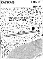
| IAP | RNAV (GPS) RWY 07 | AK-1 | |
| IAP | RNAV (GPS)-A | AK-1 | |
| MIN | ALTERNATE MINIMUMS | AK-1 | |
| MIN | TAKEOFF MINIMUMS | AK-1 |
Terminal Procedures are only available for airports in several countries with more being added all the time. If you are looking for a specific country's charts, please send an email to support(at)airportguide.com stating the country name. This will be used to prioritize the implementation.
Navigation Aids (Navaids) near KLG
| Dist (NM) | ID | Morse Code | Name | Type | Freq | True Hdg | Mag Hdg |
|---|---|---|---|---|---|---|---|
| 21.6 | ANI | . _ _ . . . | Aniak | NDB | 359 | 81 | 70 |
| 62.1 | BET | _ . . . . _ | Bethel | VORTAC | 114.10 | 224 | 214 |
| 62.8 | OSE | _ _ _ . . . . | Oscarville | NDB | 251 | 225 | 215 |
| 66.5 | ANV | . _ _ . . . . _ | Anvik | NDB | 365 | 3 | 353 |
| 89.0 | SMA | . . . _ _ . _ | St Marys | NDB | 230 | 291 | 281 |
Nearby Airports with Fuel
| Dist (NM) | Name (Airport IDs) | True Hdg | Mag Hdg | Fuel Grade |
|---|---|---|---|---|
| 23.0 | Aniak Airport (ANI PANI ANI) |
82 | 71 | 100LL, Jet A |
| 62.7 | Bethel Airport (BET PABE BET) |
224 | 214 | 100, 100LL, Jet A, Jet A-1 |
| 65.9 | Crooked Creek Airport (CKD CJX) |
71 | 60 | MOGAS |
Notices to Airmen (NOTAMS)
Remarks
| A110-1 | RWY CONDITION NOT MONITORED; RECOMMEND VISUAL INSPECTION PRIOR TO USING. |
| A110-2 | WX CAMERA AVBL ON INTERNET AT HTTPS://WEATHERCAMS.FAA.GOV. |
| A110-3 | LARGE WILDLIFE ON OR INVOF RWY. |
| A81-APT | ACTVT PAPI RWY 07 & 25; MIRL RWY 07/25 - CTAF. |
| A81-BCN | ACTVT ROTG BCN - CTAF. |
Runways
Runway Summary
| Runways: | 07/25 |
| Longest Runway: | 07/25 is 3198 ft (975 m) long |
| Runways with an Instrument Approach: |
KLG Airport Runway Details
| Runway 07/25 | 3198 ft x 75 ft (975 m x 23 m) | |
| Runway Length Source: | 3RD PARTY SURVEY as of 07/08/2013 | |
| Surface: | Gravel - Good condition - No special surface treatment | |
| Runway Edge Lights: | Medium Intensity | |
Runway 07 |
Runway 25 |
|
Elevation: |
62.0 | 62.9 |
Latitude: |
61-32-07.1239N | 61-32-11.8602N |
Longitude: |
160-21-16.7400W | 160-20-11.5198W |
|
Runway True Alignment: |
081 | 261 |
Glide Path Angle: |
3.0 degrees | 3.0 degrees |
Traffic Pattern: |
Right | |
Runway Markings Type: |
Basic | Basic |
Runway Markings Condition: |
Good | Good |
Object at End: |
TREE | TREE |
Object Height: |
63 | 8 |
Distance from End: |
0 | 241 |
Object Centerline Offset: |
115 ft. right of centerline | 105 ft. left of centerline |
Visual Glide Slope Indicators: |
4-Light PAPI On Left Side Of Runway | 4-Light PAPI On Left Side Of Runway |
Threshold Crossing Height: |
25 | 25 |
Services
Fuel Available: |
MOGAS |
Landing Fees: |
No |
Maps & Diagrams
KLG Sectional
Flight Planning
at skyvector.com
at skyvector.com