Location
Latitude: |
37-14-21.0290N (37.239175) |
Longitude: |
076-42-57.9460W (-76.716096) |
Elevation: |
49.0 feet MSL (15 m MSL) |
Magnetic Variation: |
10.7 W (as of April 2024 from WMM2020 model) |
Time Zone: |
UTC -5.0 (Standard Time) UTC -4.0 (Daylight Savings Time) |
From City: |
03 N.M. SW of Williamsburg, Virginia |
Found On: |
Washington Chart |
FAA Region: |
AEA |
Contacts
Manager: |
Privately owned: |
| LARRY T. WALTRIP 100 MARCLAY RD WILLIAMSBURG, VA 23185 757-229-9256 |
WILLIAMSBURG-JAMESTOWN ARPT. 100 MARCLAY RD WILLIAMSBURG, VA 23185 757-229-9256 |
Operations
Airport Status: |
Operational |
Facility Use: |
Public |
Type: |
Airport |
Activation Date: |
08/1970 |
Control tower: |
No |
Attendance (Months/Days/Hours): |
Months/Days/Hours NOV-FEB/ALL/0800-1800 |
Boundary ARTCC: |
ZDC (Washington) |
Responsible ARTCC: |
ZDC (Washington) |
Lighting Schedule: |
SEE RMK |
Segmented Circle Indicator: |
No |
Traffic Pattern Altitude (MSL): |
1049 feet (320 m) |
NOTAMs Facility: |
JGG |
NOTAM-D Service: |
Yes |
International Airport of Entry: |
No |
Customs Landing Rights: |
No |
Military Landing Rights: |
No |
Civil/Military Joint Use: |
No |
Based Aircraft
| Single Engine: | 58 |
| Multi Engine: | 1 |
Annual Operations (as of 12/31/2018)
| Total Operations: | 29280 | |
| Air Taxi: | 2754 | 9.4% |
| GA Local: | 15314 | 52.3% |
| GA Itinerant: | 11013 | 37.6% |
| Military Aircraft: | 199 | 0.7% |
Communications
| CTAF: | 122.800 |
| Unicom: | 122.800 |
| Approach: | NORFOLK 119.45 119.45 |
| Departure: | NORFOLK 119.45 119.45 |
| AWOS-3: | 120.625 (757-220-8810) |
Fixed Based Operators (FBOs) & Fuel
(Click on a business for detail)
Please help us keep this information up to date. This is a FREE SERVICE just like everything else on Airport Guide! If you see that a business needs to be added, modified, or deleted please fill out our Update Form.
To add, modify, or delete a business click here.
Please help us keep this information up to date. This is a FREE SERVICE just like everything else on Airport Guide! If you see that a business needs to be added, modified, or deleted please fill out our Update Form.
Area Code: 757 |
| Business Name | Frequency | Phone | Fuel Grade |
|---|
Flight Service Stations
| Primary | Alternate | |
| FSS on Field: | N | |
| FSS Name (ID): | Leesburg(DCA) | |
| Frequency: | ||
| Toll Free Phone: | 1-800-WX-BRIEF |
Instrument Procedures / Charts
FAA Terminal Procedures valid from 0901Z 03/21/24 to 0901Z 04/18/24.
There are various types of charts available for an airport. They are listed in the Page Type column. Here is a legend for those types:
APD - Airport Diagram
DP - Departure Procedure Charts
HOT - Hot Spots
IAP - Instrument Approach Procedure Charts
MIN - Minimums
STAR - Standard Terminal Arrival Charts
| Page Type | Page Name | Volume | Action Since Last Cycle |
|---|---|---|---|
| IAP | RNAV (GPS)-C | NE-3 | |
| IAP | VOR-B | NE-3 | |
| MIN | ALTERNATE MINIMUMS | NE-3 | |
| MIN | TAKEOFF MINIMUMS | NE-3 |
Terminal Procedures are only available for airports in several countries with more being added all the time. If you are looking for a specific country's charts, please send an email to support(at)airportguide.com stating the country name. This will be used to prioritize the implementation.
Navigation Aids (Navaids) near KJGG
| Dist (NM) | ID | Morse Code | Name | Type | Freq | True Hdg | Mag Hdg |
|---|---|---|---|---|---|---|---|
| 7.6 | FAF | . . _ . . _ . . _ . | Felker | NDB | 226 | 142 | 153 |
| 12.4 | PJS | . _ _ . . _ _ _ . . . | Henry | NDB | 375 | 120 | 131 |
| 12.6 | HCM | . . . . _ . _ . _ _ | Harcum | VORTAC | 108.80 | 1 | 12 |
| 19.4 | LFI | . _ . . . . _ . . . | Langley | TACAN | 112.30 | 118 | 129 |
| 19.8 | HPW | . . . . . _ _ . . _ _ | Hopewell | VORTAC | 112.00 | 285 | 296 |
| 20.6 | AKQ | . _ _ . _ _ _ . _ | Wakefield | NDB | 274 | 221 | 232 |
| 27.6 | NGU | _ . _ _ . . . _ | Chambers | TACAN | 113.95 | 130 | 141 |
| 32.3 | ORF | _ _ _ . _ . . . _ . | Norfolk | VORTAC | 116.90 | 130 | 141 |
| 32.7 | OR | _ _ _ . _ . | Ingle | NDB | 329 | 136 | 147 |
| 32.9 | RIC | . _ . . . _ . _ . | Richmond | VORTAC | 114.10 | 298 | 309 |
| 34.6 | FKN | . . _ . _ . _ _ . | Franklin | VORTAC | 110.60 | 204 | 215 |
| 34.9 | CCV | _ . _ . _ . _ . . . . _ | Cape Charles | VORTAC | 112.20 | 79 | 90 |
| 35.6 | CF | _ . _ . . . _ . | Pubbs | NDB | 392 | 279 | 290 |
| 38.5 | RK | . _ . _ . _ | Waley | NDB | 249 | 175 | 186 |
| 41.0 | NTU | _ . _ . . _ | Oceana | TACAN | 116.60 | 127 | 138 |
| 41.6 | EY | . _ . _ _ | Chesi | NDB | 233 | 157 | 168 |
| 48.0 | BDB | _ . . . _ . . _ . . . | Accom | NDB | 336 | 65 | 76 |
| 50.5 | ELQ | . . _ . . _ _ . _ | Emporia | NDB | 261 | 222 | 232 |
| 52.5 | CVI | _ . _ . . . . _ . . | Cofield | VORTAC | 114.60 | 188 | 199 |
| 55.8 | FAK | . . _ . . _ _ . _ | Flat Rock | VORTAC | 113.30 | 288 | 298 |
Nearby Airports with Fuel
Notices to Airmen (NOTAMS)
Remarks
| A110*G | THIS AIRPORT HAS BEEN SURVEYED BY THE NATIONAL GEODETIC SURVEY. |
| A110-2 | DEER & BIRDS ON & INVOF ARPT. |
| A110-3 | NOISE ABATEMENT PROCEDURES IN EFFECT; CTC AMGR 757-229-9256. RY 31 DEP TURN LEFT HEADING 270 DEG TO AVOID SCHOOL 3500 FT OFF RY END. |
| A110-4 | GCO AVBL ON FREQ 135.075 THRU NORFOLK CD, 4 CLICKS NORFOLK, 5 LEESBURG RADIO (CLICK SLOWLY). IF UN, FOR CD CTC NORFOLK APCH AT 757-464-0757. |
| A110-5 | HELIPAD CLSD CT 122.8 FOR LDG INSTRUCTIONS. |
| A110-6 | PAEW ADJECENT TO RY 13/31. |
| A17 | ARPT UNATTND CHRISTMAS DAY - ATTND BY REQUEST. |
| A24 | LANDING FEE FOR COML & CHTR ACFT. |
| A58-31 | 20 FT TREE 156 FT FM THR 106 L OF CNTRLN; BRUSH APRX 127 FT FM THR, ARND PEN EDGE, 15 FT ABV RWY END. |
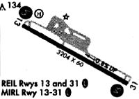
| A81-APT | ACTVT REIL RWY 13 & 31; MIRL RY 13/31; PERIMETER LGTS RY H1 - CTAF. |
Runways
Runway Summary
| Runways: | 13/31 H1 |
| Longest Runway: | 13/31 is 3204 ft (977 m) long |
| Runways with an Instrument Approach: |
KJGG Airport Runway Details
| Runway 13/31 | 3204 ft x 60 ft (977 m x 18 m) | |
| Surface: | Asphalt - Fair condition - No special surface treatment | |
| Runway Edge Lights: | Medium Intensity | |
Runway Weight Bearing Capacity (in thousands of pounds) |
||
| Single Wheel Landing Gear: | 12.5 | |
Runway 13 |
Runway 31 |
|
Elevation: |
48.0 | 22.0 |
Latitude: |
37-14-29.0230N | 37-14-13.0090N |
Longitude: |
076-43-15.0220W | 076-42-40.8310W |
|
Runway True Alignment: |
120 | 300 |
Glide Path Angle: |
0.0 degrees | 0.0 degrees |
Traffic Pattern: |
Right | Left |
Runway Markings Type: |
Basic | Basic |
Runway Markings Condition: |
Fair | Fair |
Object at End: |
TREES | |
Object Height: |
106 | |
Distance from End: |
2016 | |
Object Centerline Offset: |
269 ft. right of centerline | |
REIL: |
Yes | Yes |
| Helipad H1 | 60 ft x 60 ft (18 m x 18 m) | |
| Surface: | Asphalt - Fair condition - No special surface treatment | |
Helipad H1 |
||
Glide Path Angle: |
0.0 degrees | 0.0 degrees |
Runway Markings Type: |
Basic | |
Runway Markings Condition: |
Fair | |
Object Centerline Offset: |
269 ft. right of centerline |
Services
Airframe Repair: |
None |
Powerplant Repair: |
None |
Fuel Available: |
100LL, Jet A |
Landing Fees: |
No |
Parking: |
Hangars and tiedowns available |
Maps & Diagrams
KJGG Sectional
Flight Planning
at skyvector.com
at skyvector.com