Location
Latitude: |
38-52-55.0041N (38.881946) |
Longitude: |
083-52-57.8520W (-83.882737) |
Elevation: |
957.6 feet MSL (292 m MSL) |
Magnetic Variation: |
6.5 W (as of April 2024 from WMM2020 model) |
Time Zone: |
UTC -5.0 (Standard Time) UTC -4.0 (Daylight Savings Time) |
From City: |
01 N.M. NE of Georgetown, Ohio |
Found On: |
Cincinnati Chart |
FAA Region: |
AGL |
Contacts
Manager: |
Publicly owned: |
| STEVE AND SANDY MCKINNEY 8862 AIRPORT ROAD GEORGETOWN, OH 45121 937-483-6212 |
BROWN CO COMM BROWN COUNTY COURTHOUSE GEORGETOWN, OH 45121 937-378-3956 |
Operations
Airport Status: |
Operational |
Facility Use: |
Public |
Type: |
Airport |
Activation Date: |
04/1971 |
Control tower: |
No |
Attendance (Months/Days/Hours): |
Months/Days/Hours Unattended |
Boundary ARTCC: |
ZID (Indianapolis) |
Responsible ARTCC: |
ZID (Indianapolis) |
Lighting Schedule: |
SEE RMK |
Segmented Circle Indicator: |
No |
Traffic Pattern Altitude (MSL): |
1958 feet (597 m) |
NOTAMs Facility: |
DAY |
NOTAM-D Service: |
Yes |
International Airport of Entry: |
No |
Customs Landing Rights: |
No |
Military Landing Rights: |
Yes |
Civil/Military Joint Use: |
No |
Based Aircraft
| Single Engine: | 9 |
Annual Operations (as of 06/23/2022)
| Total Operations: | 7876 | |
| Air Taxi: | 276 | 3.5% |
| GA Local: | 5500 | 69.8% |
| GA Itinerant: | 2000 | 25.4% |
| Military Aircraft: | 100 | 1.3% |
Communications
| CTAF: | 122.900 |
- APCH/DEP SVC PRVDD BY INDIANAPOLIS ARTCC ON FREQS 135.575/290.5 (MERWYN RCAG).
Fixed Based Operators (FBOs) & Fuel
(Click on a business for detail)
Please help us keep this information up to date. This is a FREE SERVICE just like everything else on Airport Guide! If you see that a business needs to be added, modified, or deleted please fill out our Update Form.
To add, modify, or delete a business click here.
Please help us keep this information up to date. This is a FREE SERVICE just like everything else on Airport Guide! If you see that a business needs to be added, modified, or deleted please fill out our Update Form.
Area Code: 937 |
| Business Name | Frequency | Phone | Fuel Grade |
|---|
Flight Service Stations
| Primary | Alternate | |
| FSS on Field: | N | |
| FSS Name (ID): | Dayton(DAY) | |
| Frequency: | ||
| Toll Free Phone: | 1-800-WX-BRIEF |
Instrument Procedures / Charts
FAA Terminal Procedures valid from 0901Z 03/21/24 to 0901Z 04/18/24.
There are various types of charts available for an airport. They are listed in the Page Type column. Here is a legend for those types:
APD - Airport Diagram
DP - Departure Procedure Charts
HOT - Hot Spots
IAP - Instrument Approach Procedure Charts
MIN - Minimums
STAR - Standard Terminal Arrival Charts
| Page Type | Page Name | Volume | Action Since Last Cycle |
|---|---|---|---|
| IAP | RNAV (GPS) RWY 36 | EC-2 | |
| IAP | VOR/DME-A | EC-2 | |
| MIN | TAKEOFF MINIMUMS | EC-2 |
Terminal Procedures are only available for airports in several countries with more being added all the time. If you are looking for a specific country's charts, please send an email to support(at)airportguide.com stating the country name. This will be used to prioritize the implementation.
Navigation Aids (Navaids) near KGEO
| Dist (NM) | ID | Morse Code | Name | Type | Freq | True Hdg | Mag Hdg |
|---|---|---|---|---|---|---|---|
| 15.0 | AMT | . _ _ _ _ | West Union | NDB | 359 | 96 | 103 |
| 19.4 | PWF | . _ _ . . _ _ . . _ . | Sportys | NDB | 245 | 307 | 313 |
| 21.5 | XW | _ . . _ . _ _ | Flmng | NDB | 400 | 149 | 156 |
| 24.1 | HOC | . . . . _ _ _ _ . _ . | Hillsboro | NDB | 278 | 40 | 47 |
| 24.4 | FLM | . . _ . . _ . . _ _ | Falmouth | VOR-DME | 117.00 | 235 | 241 |
| 26.1 | PZO | . _ _ . _ _ . . _ _ _ | Peebles | NDB | 329 | 84 | 91 |
| 27.1 | LUK | . _ . . . . _ _ . _ | Cincinnati | NDB | 335 | 308 | 314 |
| 28.3 | HW | . . . . . _ _ | Cubla | NDB | 299 | 0 | 7 |
| 28.6 | LUK | . _ . . . . _ _ . _ | Cincinnati Muni/Lunken | VOT | 108.40 | 298 | 304 |
| 30.1 | MDE | _ _ _ . . . | Madeira | NDB | 379 | 313 | 319 |
| 33.1 | MXQ | _ _ _ . . _ _ _ . _ | Midwest | VOR-DME | 112.90 | 6 | 13 |
| 37.3 | IL | . . . _ . . | Airbo | NDB | 407 | 10 | 17 |
| 39.1 | CVG | _ . _ . . . . _ _ _ . | Cincinnati | VORTAC | 117.30 | 282 | 288 |
| 42.7 | UR | . . _ . _ . | Burln | NDB | 321 | 283 | 289 |
| 43.6 | HAO | . . . . . _ _ _ _ | Hamilton | NDB | 260 | 312 | 318 |
| 44.7 | YRK | _ . _ _ . _ . _ . _ | York | VORTAC | 112.80 | 108 | 115 |
| 45.4 | HKF | . . . . _ . _ . . _ . | Hook Field | NDB | 239 | 324 | 330 |
| 46.5 | MW | _ _ . _ _ | Onida | NDB | 223 | 334 | 340 |
| 47.5 | EOP | . _ _ _ . _ _ . | Waverly | NDB | 385 | 68 | 75 |
| 48.8 | CSS | _ . _ . . . . . . . | Court House | NDB | 414 | 27 | 34 |
Nearby Airports with Fuel
Notices to Airmen (NOTAMS)
Remarks
| A110*G | THIS AIRPORT HAS BEEN SURVEYED BY THE NATIONAL GEODETIC SURVEY. |
| A110-2 | FOR CD CTC INDIANAPOLIS ARTCC AT 317-247-2411. |
| A16 | ADNL CTC: HOME 937-379-1634; BUS 937-379-1055. SPMCKINNEY53@GMAIL.COM |
| A52-18 | ALSO 10 FT ROAD, 300 FT FM, 0 B, APCH RATIO 10:1. |
| A70-FUEL-10 | 0LL SELF SERVICE FUEL AVBL 24 HRS WITH CREDIT CARD. |
| A71 | FOR AIRFRAME & POWERPLANT REPAIRS PHONE 937-379-1055. |
| A75 | TSNT HNGR, PRIOR CDN RQRD, TIEDOWN NO ROPES PRVDD. |
| A81-APT | ACTVT REIL RWY 18 & 36; MIRL RWY 18/36 - CTAF. |
Runways
Runway Summary
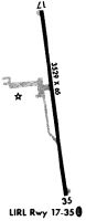
| Runways: | 18/36 |
| Longest Runway: | 18/36 is 3530 ft (1076 m) long |
| Runways with an Instrument Approach: |
KGEO Airport Runway Details
| Runway 18/36 | 3530 ft x 65 ft (1076 m x 20 m) | |
| Runway Length Source: | NGS as of 11/27/1995 | |
| Surface: | Asphalt - Fair condition - No special surface treatment | |
| Runway Edge Lights: | Medium Intensity | |
Runway 18 |
Runway 36 |
|
Elevation: |
955.6 | 953.3 |
Latitude: |
38-53-12.1940N | 38-52-37.8141N |
Longitude: |
083-53-01.6527W | 083-52-54.0519W |
|
Runway True Alignment: |
170 | 350 |
Glide Path Angle: |
3.0 degrees | 3.0 degrees |
Traffic Pattern: |
Left | Left |
Runway Markings Type: |
Nonprecision Instrument | Nonprecision Instrument |
Runway Markings Condition: |
Fair | Fair |
Object at End: |
TREES | TREE |
Object Height: |
100 | 40 |
Distance from End: |
854 | 438 |
Object Centerline Offset: |
186 ft. right of centerline | 245 ft. right of centerline |
Visual Glide Slope Indicators: |
4-Light PAPI On Left Side Of Runway | 4-Light PAPI On Left Side Of Runway |
REIL: |
Yes | Yes |
Touchdown Lights: |
No | No |
Threshold Crossing Height: |
40 | 40 |
Services
Airframe Repair: |
None |
Powerplant Repair: |
None |
Bottled Oxygen: |
None |
Bulk Oxygen: |
None |
Fuel Available: |
100LL, Jet A-1+ |
Landing Fees: |
No |
Parking: |
Hangars and tiedowns available |
Maps & Diagrams
KGEO Sectional
Flight Planning
at skyvector.com
at skyvector.com