Location
Latitude: |
36-32-07.1000N (36.535306) |
Longitude: |
089-35-59.0000W (-89.599722) |
Elevation: |
295.8 feet MSL (90 m MSL) |
Magnetic Variation: |
2.2 W (as of April 2024 from WMM2020 model) |
Time Zone: |
UTC -6.0 (Standard Time) UTC -5.0 (Daylight Savings Time) |
From City: |
04 N.M. SW of New Madrid, Missouri |
Found On: |
St Louis Chart |
FAA Region: |
ACE |
Contacts
Manager: |
Publicly owned: |
| BUSTER HAMPTON P.O. BOX 668 NEW MADRID, MO 63869 (573) 643-2403 |
COUNTY OF NEW MADRID 450 MAIN STREET, PO BOX 68 NEW MADRID, MO 63869 573-748-2524 |
Operations
Airport Status: |
Operational |
Facility Use: |
Public |
Type: |
Airport |
Control tower: |
No |
Attendance (Months/Days/Hours): |
Months/Days/Hours OCT-MAR/MON-FRI/0800-1630 |
Boundary ARTCC: |
ZME (Memphis) |
Responsible ARTCC: |
ZME (Memphis) |
Lighting Schedule: |
SEE RMK |
Segmented Circle Indicator: |
Yes |
Traffic Pattern Altitude (MSL): |
1296 feet (395 m) |
NOTAMs Facility: |
STL |
NOTAM-D Service: |
Yes |
International Airport of Entry: |
No |
Customs Landing Rights: |
No |
Military Landing Rights: |
Yes |
Civil/Military Joint Use: |
No |
Based Aircraft
| Single Engine: | 6 |
| GA Helicopters: | 1 |
Annual Operations (as of 12/31/2021)
| Total Operations: | 17000 | |
| Air Taxi: | 900 | 5.3% |
| GA Local: | 12250 | 72.1% |
| GA Itinerant: | 3800 | 22.4% |
| Military Aircraft: | 50 | 0.3% |
Communications
| CTAF: | 122.800 |
| Unicom: | 122.800 |
- APCH/DEP SVC PRVDD BY MEMPHIS ARTCC ON FREQS 133.65/292.15 (PADUCAH RCAG).
Fixed Based Operators (FBOs) & Fuel
(Click on a business for detail)
Please help us keep this information up to date. This is a FREE SERVICE just like everything else on Airport Guide! If you see that a business needs to be added, modified, or deleted please fill out our Update Form.
To add, modify, or delete a business click here.
Please help us keep this information up to date. This is a FREE SERVICE just like everything else on Airport Guide! If you see that a business needs to be added, modified, or deleted please fill out our Update Form.
Area Code: 573 |
| Business Name | Frequency | Phone | Fuel Grade |
|---|---|---|---|
| Turner Aircraft Services
Update FBO info |
Unicom 122.8 | 643-2387 | 100LL |
Flight Service Stations
| Primary | Alternate | |
| FSS on Field: | N | |
| FSS Name (ID): | Saint Louis(STL) | |
| Frequency: | ||
| Toll Free Phone: | 1-800-WX-BRIEF |
Instrument Procedures / Charts
FAA Terminal Procedures valid from 0901Z 03/21/24 to 0901Z 04/18/24.
There are various types of charts available for an airport. They are listed in the Page Type column. Here is a legend for those types:
APD - Airport Diagram
DP - Departure Procedure Charts
HOT - Hot Spots
IAP - Instrument Approach Procedure Charts
MIN - Minimums
STAR - Standard Terminal Arrival Charts
| Page Type | Page Name | Volume | Action Since Last Cycle |
|---|---|---|---|
| IAP | RNAV (GPS) RWY 18 | NC-3 | |
| IAP | RNAV (GPS) RWY 36 | NC-3 | |
| MIN | TAKEOFF MINIMUMS | NC-3 |
Terminal Procedures are only available for airports in several countries with more being added all the time. If you are looking for a specific country's charts, please send an email to support(at)airportguide.com stating the country name. This will be used to prioritize the implementation.
Navigation Aids (Navaids) near KEIW
| Dist (NM) | ID | Morse Code | Name | Type | Freq | True Hdg | Mag Hdg |
|---|---|---|---|---|---|---|---|
| 15.1 | MAW | _ _ . _ . _ _ | Malden | TACAN | 111.20 | 274 | 276 |
| 22.0 | CHQ | _ . _ . . . . . _ _ . _ | Charleston | NDB | 208 | 32 | 34 |
| 32.5 | UC | . . _ _ . _ . | Obion | NDB | 212 | 115 | 117 |
| 33.9 | DYR | _ . . _ . _ _ . _ . | Dyersburg | TACAN | 116.80 | 156 | 158 |
| 36.0 | FD | . . _ . _ . . | Earli | NDB | 278 | 283 | 285 |
| 36.4 | CIR | _ . _ . . . . _ . | Cairo | NDB | 397 | 29 | 31 |
| 38.8 | GOJ | _ _ . _ _ _ . _ _ _ | Gosnell | VOR | 111.80 | 205 | 207 |
| 41.6 | CGI | _ . _ . _ _ . . . | Cape Girardeau | DME | 112.9 | 1 | 3 |
| 43.4 | CG | _ . _ . _ _ . | Dutch | NDB | 248 | 353 | 355 |
| 46.4 | CNG | _ . _ . _ . _ _ . | Cunningham | VOR-DME | 113.10 | 52 | 55 |
| 56.7 | COO | _ . _ . _ _ _ _ _ _ | Covington | NDB | 326 | 179 | 181 |
| 57.7 | BDD | _ . . . _ . . _ . . | Bellgrade | NDB | 254 | 50 | 53 |
| 59.7 | TIQ | _ . . _ _ . _ | Trainer | NDB | 410 | 106 | 109 |
| 61.0 | HZD | . . . . _ _ . . _ . . | Huntingdon | NDB | 217 | 115 | 118 |
| 62.1 | JBR | . _ _ _ _ . . . . _ . | Jonesboro | VOR-DME | 115.85 | 230 | 232 |
| 64.0 | EU | . . . _ | Murey | NDB | 368 | 79 | 82 |
| 65.1 | MKL | _ _ _ . _ . _ . . | Mc Kellar | VOR-DME | 112.00 | 148 | 150 |
| 66.9 | TNZ | _ _ . _ _ . . | Lawrence County | NDB | 227 | 253 | 255 |
| 68.7 | MKL | _ _ _ . _ . _ . . | Mersy | NDB | 394 | 152 | 154 |
| 70.3 | ARG | . _ . _ . _ _ . | Walnut Ridge | VORTAC | 114.50 | 249 | 251 |
Nearby Airports with Fuel
Notices to Airmen (NOTAMS)
Remarks
| A110-1 | CROP DUSTING ACFT ON & INVOF ARPT. |
| A110-2 | WATERFOWL INVOF ARPT. |
| A110-3 | FOR CD CTC MEMPHIS ARTCC AT 901-368-8453/8449. |
| A14 | COUNTY CLERK. |
| A70-FUEL-10 | 0LL FOR SVC AFT HRS, CALL ARPT MGR AT (573) 643-2403 OR (573) 934-3734. |
| A81-APT | MIRL RWY 18/36 PRESET ON MED INTST; TO INCR INTST & ACTVT MIRL RWY 18/36 - CTAF. |
| A82 | UNICOM UNMON. |
Runways
Runway Summary
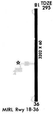
| Runways: | 18/36 |
| Longest Runway: | 18/36 is 3200 ft (975 m) long |
| Runways with an Instrument Approach: |
KEIW Airport Runway Details
| Runway 18/36 | 3200 ft x 60 ft (975 m x 18 m) | |
| Runway Length Source: | 3RD PARTY SURVEY as of 05/04/2007 | |
| Surface: | Asphalt - Good condition - No special surface treatment | |
| Runway Edge Lights: | Medium Intensity | |
Runway 18 |
Runway 36 |
|
Elevation: |
294.8 | 295.8 |
Latitude: |
36-32-22.9300N | 36-31-51.2900N |
Longitude: |
089-35-59.0700W | 089-35-58.9400W |
|
Runway True Alignment: |
180 | 360 |
Glide Path Angle: |
0.0 degrees | 0.0 degrees |
Traffic Pattern: |
Left | Left |
Runway Markings Type: |
Nonprecision Instrument | Nonprecision Instrument |
Runway Markings Condition: |
Good | Good |
Object at End: |
ROAD | TREES |
Object Height: |
15 | 22 |
Distance from End: |
300 | 550 |
Object Centerline Offset: |
250 ft. left and right of centerline | 300 ft. left and right of centerline |
Services
Airframe Repair: |
Major |
Powerplant Repair: |
Major |
Bottled Oxygen: |
None |
Bulk Oxygen: |
None |
Fuel Available: |
100LL, Jet A+ |
Parking: |
Hangars and tiedowns available |
Maps & Diagrams
KEIW Sectional
Flight Planning
at skyvector.com
at skyvector.com