Location
Latitude: |
35-43-26.7000N (35.724083) |
Longitude: |
096-49-13.0000W (-96.820278) |
Elevation: |
985.4 feet MSL (300 m MSL) |
Magnetic Variation: |
2.7 E (as of April 2024 from WMM2020 model) |
Time Zone: |
UTC -6.0 (Standard Time) UTC -5.0 (Daylight Savings Time) |
From City: |
03 N.M. NE of Chandler, Oklahoma |
Found On: |
Dallas-Ft Worth Chart |
FAA Region: |
ASW |
Contacts
Manager: |
Publicly owned: |
| JASON ORR 414 MANVEL CHANDLER, OK 74834 405-258-3200 |
CITY OF CHANDLER 414 MANVEL CHANDLER, OK 74834 405-258-3200 |
Operations
Airport Status: |
Operational |
Facility Use: |
Public |
Type: |
Airport |
Activation Date: |
06/1960 |
Control tower: |
No |
Attendance (Months/Days/Hours): |
Months/Days/Hours Unattended |
Boundary ARTCC: |
ZKC (Kansas City) |
Responsible ARTCC: |
ZKC (Kansas City) |
Lighting Schedule: |
SEE RMK |
Segmented Circle Indicator: |
Yes |
Traffic Pattern Altitude (MSL): |
1985 feet (605 m) |
NOTAMs Facility: |
CQB |
NOTAM-D Service: |
Yes |
International Airport of Entry: |
No |
Customs Landing Rights: |
No |
Military Landing Rights: |
Yes |
Civil/Military Joint Use: |
No |
Based Aircraft
| Single Engine: | 9 |
| Multi Engine: | 3 |
| Jet Engine: | 1 |
Annual Operations (as of 09/22/2023)
| Total Operations: | 6500 | |
| Air Taxi: | 500 | 7.7% |
| GA Local: | 2200 | 33.8% |
| GA Itinerant: | 3800 | 58.5% |
Communications
| CTAF: | 122.900 |
| AWOS-3PT: | 119.275 (405-258-6724) |
- APCH/DEP CTL SVC PRVDD BY KANSAS CITY ARTCC (ZKC) ON FREQS 127.8/319.1 (OKLAHOMA CITY RCAG).
Fixed Based Operators (FBOs) & Fuel
(Click on a business for detail)
Please help us keep this information up to date. This is a FREE SERVICE just like everything else on Airport Guide! If you see that a business needs to be added, modified, or deleted please fill out our Update Form.
To add, modify, or delete a business click here.
Please help us keep this information up to date. This is a FREE SERVICE just like everything else on Airport Guide! If you see that a business needs to be added, modified, or deleted please fill out our Update Form.
Area Code: 405 |
| Business Name | Frequency | Phone | Fuel Grade |
|---|
Flight Service Stations
| Primary | Alternate | |
| FSS on Field: | N | |
| FSS Name (ID): | Mc Alester(MLC) | |
| Frequency: | ||
| Toll Free Phone: | 1-800-WX-BRIEF |
Instrument Procedures / Charts
FAA Terminal Procedures valid from 0901Z 03/21/24 to 0901Z 04/18/24.
There are various types of charts available for an airport. They are listed in the Page Type column. Here is a legend for those types:
APD - Airport Diagram
DP - Departure Procedure Charts
HOT - Hot Spots
IAP - Instrument Approach Procedure Charts
MIN - Minimums
STAR - Standard Terminal Arrival Charts
| Page Type | Page Name | Volume | Action Since Last Cycle |
|---|---|---|---|
| IAP | RNAV (GPS) RWY 17 | SC-1 | |
| IAP | RNAV (GPS) RWY 35 | SC-1 | |
| MIN | ALTERNATE MINIMUMS | SC-1 | |
| MIN | TAKEOFF MINIMUMS | SC-1 |
Terminal Procedures are only available for airports in several countries with more being added all the time. If you are looking for a specific country's charts, please send an email to support(at)airportguide.com stating the country name. This will be used to prioritize the implementation.
Navigation Aids (Navaids) near KCQB
| Dist (NM) | ID | Morse Code | Name | Type | Freq | True Hdg | Mag Hdg |
|---|---|---|---|---|---|---|---|
| 0.1 | CQB | _ . _ . _ _ . _ _ . . . | Tilghman | NDB | 396 | 50 | 47 |
| 10.2 | CUH | _ . _ . . . _ . . . . | Cushing | NDB | 242 | 12 | 9 |
| 13.4 | GGU | _ _ . _ _ . . . _ | Prague | NDB | 314 | 158 | 155 |
| 17.5 | HN | . . . . _ . | Suybe | NDB | 264 | 200 | 197 |
| 28.0 | SRE | . . . . _ . . | Seminole | NDB | 278 | 165 | 162 |
| 32.3 | TIK | _ . . _ . _ | Tinker | TACAN | 115.80 | 237 | 234 |
| 32.6 | SWO | . . . . _ _ _ _ _ | Stillwater | VOR-DME | 108.40 | 337 | 334 |
| 33.4 | SW | . . . . _ _ | Gabeh | NDB | 255 | 337 | 334 |
| 41.2 | OK | _ _ _ _ . _ | Tuloo | NDB | 406 | 248 | 245 |
| 41.9 | PWA | . _ _ . . _ _ . _ | Wiley Post | VOR-DME | 113.40 | 254 | 251 |
| 42.1 | OWP | _ _ _ . _ _ . _ _ . | William Pogue | NDB | 362 | 50 | 48 |
| 42.5 | OK | _ _ _ _ . _ | Preso | NDB | 388 | 87 | 85 |
| 42.7 | OUN | _ _ _ . . _ _ . | Norman | NDB | 370 | 228 | 225 |
| 43.1 | GNP | _ _ . _ . . _ _ . | Glenpool | DME | 110.6 | 73 | 71 |
| 43.7 | OKC | _ _ _ _ . _ _ . _ . | Oklahoma Will Rgs W | VOT | 112.15 | 241 | 238 |
| 43.8 | HET | . . . . . _ | Henryetta | NDB | 267 | 115 | 113 |
| 44.3 | IRW | . . . _ . . _ _ | Will Rogers | VORTAC | 114.10 | 240 | 237 |
| 45.5 | RG | . _ . _ _ . | Gally | NDB | 350 | 235 | 232 |
| 46.3 | HMY | . . . . _ _ _ . _ _ | Muldrow | NDB | 512 | 205 | 202 |
| 46.5 | OKM | _ _ _ _ . _ _ _ | Okmulgee | VOR-DME | 114.90 | 92 | 90 |
Nearby Airports with Fuel
Notices to Airmen (NOTAMS)
Remarks
| A110-1 | FOR CD CTC KANSAS CITY ARTCC AT 913-254-8508. |
| A14 | CITY MANAGER. |
| A70-FUEL-10 | 0LL FUEL AVBL 24 HRS WITH CREDIT CARD ADPS. |
| A81-APT | ACTVT PAPI RWY 17 & 35; MIRL RWY 17/35 - CTAF. |
Runways
Runway Summary
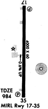
| Runways: | 17/35 |
| Longest Runway: | 17/35 is 4000 ft (1219 m) long |
| Runways with an Instrument Approach: |
KCQB Airport Runway Details
| Runway 17/35 | 4000 ft x 60 ft (1219 m x 18 m) | |
| Runway Length Source: | 3RD PARTY SURVEY as of 08/19/2011 | |
| Surface: | Asphalt - Good condition - No special surface treatment | |
| Runway Edge Lights: | Medium Intensity | |
Runway Weight Bearing Capacity (in thousands of pounds) |
||
| Single Wheel Landing Gear: | 12.5 | |
Runway 17 |
Runway 35 |
|
Elevation: |
960.9 | 985.4 |
Latitude: |
35-43-46.4657N | 35-43-06.9342N |
Longitude: |
096-49-12.8967W | 096-49-13.0995W |
|
Runway True Alignment: |
180 | 360 |
Glide Path Angle: |
3.0 degrees | 3.0 degrees |
Traffic Pattern: |
Left | Left |
Runway Markings Type: |
Nonprecision Instrument | Nonprecision Instrument |
Runway Markings Condition: |
Fair | Fair |
Object at End: |
TREE | |
Object Height: |
17 | |
Distance from End: |
460 | |
Object Centerline Offset: |
255 ft. left of centerline | |
Visual Glide Slope Indicators: |
4-Light PAPI On Left Side Of Runway | 4-Light PAPI On Left Side Of Runway |
Threshold Crossing Height: |
42 | 42 |
Services
Airframe Repair: |
Major |
Powerplant Repair: |
Major |
Bulk Oxygen: |
High Pressure / Low Pressure |
Fuel Available: |
100LL, Jet A+ |
Landing Fees: |
Yes |
Parking: |
Hangars and tiedowns available |
Maps & Diagrams
KCQB Sectional
Flight Planning
at skyvector.com
at skyvector.com