Location
Latitude: |
39-58-28.6500N (39.974625) |
Longitude: |
086-55-15.8700W (-86.921075) |
Elevation: |
800.4 feet MSL (244 m MSL) |
Magnetic Variation: |
4.4 W (as of April 2024 from WMM2020 model) |
Time Zone: |
UTC -5.0 (Standard Time) UTC -4.0 (Daylight Savings Time) |
From City: |
04 N.M. S of Crawfordsville, Indiana |
Found On: |
St Louis Chart |
FAA Region: |
AGL |
Contacts
Manager: |
Publicly owned: |
| LORI CURLESS 759 W 400 S CRAWFORDSVILLE, IN 47933 (765) 362-0707 |
CITY OF CRAWFORDSVILLE 759 W 400 S CRAWFORDSVILLE, IN 47933 765-362-0707 |
Operations
Airport Status: |
Operational |
Facility Use: |
Public |
Type: |
Airport |
Activation Date: |
06/1945 |
Control tower: |
No |
Attendance (Months/Days/Hours): |
Months/Days/Hours ALL/ALL/0900-1700 |
Boundary ARTCC: |
ZID (Indianapolis) |
Responsible ARTCC: |
ZID (Indianapolis) |
Lighting Schedule: |
SEE RMK |
Segmented Circle Indicator: |
No |
Traffic Pattern Altitude (MSL): |
1800 feet (549 m) |
NOTAMs Facility: |
HUF |
NOTAM-D Service: |
Yes |
International Airport of Entry: |
No |
Customs Landing Rights: |
No |
Military Landing Rights: |
Yes |
Civil/Military Joint Use: |
No |
Based Aircraft
| Single Engine: | 29 |
| Multi Engine: | 2 |
Annual Operations (as of 12/31/2019)
| Total Operations: | 22922 | |
| GA Local: | 15130 | 66.0% |
| GA Itinerant: | 7792 | 34.0% |
Communications
| CTAF: | 122.800 |
| Unicom: | 122.800 |
| Approach: | INDIANAPOLIS 119.05 119.05 |
| Departure: | INDIANAPOLIS 119.05 119.05 |
| AWOS-3PT: | 125.650 (765-362-2967) |
Fixed Based Operators (FBOs) & Fuel
(Click on a business for detail)
Please help us keep this information up to date. This is a FREE SERVICE just like everything else on Airport Guide! If you see that a business needs to be added, modified, or deleted please fill out our Update Form.
To add, modify, or delete a business click here.
Please help us keep this information up to date. This is a FREE SERVICE just like everything else on Airport Guide! If you see that a business needs to be added, modified, or deleted please fill out our Update Form.
Area Code: 765 |
| Business Name | Frequency | Phone | Fuel Grade |
|---|
Flight Service Stations
| Primary | Alternate | |
| FSS on Field: | N | |
| FSS Name (ID): | Terre Haute(HUF) | |
| Frequency: | ||
| Toll Free Phone: | 1-800-WX-BRIEF |
Instrument Procedures / Charts
FAA Terminal Procedures valid from 0901Z 03/21/24 to 0901Z 04/18/24.
There are various types of charts available for an airport. They are listed in the Page Type column. Here is a legend for those types:
APD - Airport Diagram
DP - Departure Procedure Charts
HOT - Hot Spots
IAP - Instrument Approach Procedure Charts
MIN - Minimums
STAR - Standard Terminal Arrival Charts
| Page Type | Page Name | Volume | Action Since Last Cycle |
|---|---|---|---|
| IAP | NDB RWY 04 | EC-2 | Changed |
| IAP | RNAV (GPS) RWY 04 | EC-2 | |
| IAP | RNAV (GPS) RWY 22 | EC-2 | |
| MIN | ALTERNATE MINIMUMS | EC-2 | |
| MIN | TAKEOFF MINIMUMS | EC-2 |
Terminal Procedures are only available for airports in several countries with more being added all the time. If you are looking for a specific country's charts, please send an email to support(at)airportguide.com stating the country name. This will be used to prioritize the implementation.
Navigation Aids (Navaids) near KCFJ
| Dist (NM) | ID | Morse Code | Name | Type | Freq | True Hdg | Mag Hdg |
|---|---|---|---|---|---|---|---|
| 0.5 | CFJ | _ . _ . . . _ . . _ _ _ | Crawfordsville | NDB | 388 | 33 | 37 |
| 16.5 | TVX | _ . . . _ _ . . _ | Greencastle | NDB | 521 | 161 | 165 |
| 24.2 | FKR | . . _ . _ . _ . _ . | Frankfort | NDB | 278 | 42 | 47 |
| 27.2 | VHP | . . . _ . . . . . _ _ . | Brickyard | VORTAC | 116.30 | 110 | 115 |
| 27.8 | LA | . _ . . . _ | Earle | NDB | 401 | 347 | 351 |
| 31.8 | IND | . . _ . _ . . | Indianapolis Intl | VOT | 109.60 | 117 | 122 |
| 32.8 | TTH | _ _ . . . . | Terre Haute | VORTAC | 115.30 | 207 | 211 |
| 33.7 | DN | _ . . _ . | Julip | NDB | 332 | 304 | 308 |
| 34.9 | DNV | _ . . _ . . . . _ | Danville | VORTAC | 111.00 | 303 | 307 |
| 35.5 | BVT | _ . . . . . . _ _ | Boiler | VORTAC | 115.10 | 349 | 353 |
| 40.1 | UMP | . . _ _ _ . _ _ . | Metropolitan | NDB | 338 | 92 | 97 |
| 41.5 | HU | . . . . . . _ | Yinno | NDB | 245 | 212 | 216 |
| 43.4 | HFY | . . . . . . _ . _ . _ _ | Greenwood | NDB | 398 | 117 | 122 |
| 47.5 | HMJ | . . . . _ _ . _ _ _ | Homer | NDB | 281 | 274 | 278 |
| 51.6 | OKK | _ _ _ _ . _ _ . _ | Kokomo | TACAN | 113.50 | 49 | 54 |
| 51.8 | OOM | _ _ _ _ _ _ _ _ | Hoosier | VORTAC | 110.20 | 163 | 168 |
| 53.4 | GUS | _ _ . . . _ . . . | Grissom | VORTAC | 108.45 | 40 | 45 |
| 54.6 | SHB | . . . . . . . _ . . . | Shelbyville | VOR-DME | 116.15 | 111 | 116 |
| 57.1 | SIV | . . . . . . . . _ | Sullivan | NDB | 326 | 205 | 209 |
| 58.0 | CM | _ . _ . _ _ | Veals | NDB | 407 | 269 | 273 |
Nearby Airports with Fuel
Notices to Airmen (NOTAMS)
Remarks
| A110-2 | ARPT CLSD TO PART 137 OPS EXCP PPR 765-362-0070. |
| A110-3 | FOR CD CTC INDIANAPOLIS APCH AT 317-227-5744. |
| A43-04 | UNUSBL BYD 8 DEGS LEFT OF CNTRLN. |
| A57-22 | APCH RATIO 55:1 FM DSPLCD THR. |
| A81-APT | ACTVT REIL RWY 04 & 22 - CTAF. MIRL RWY 04/22 PRESET TO LOW INTST; INCR INTST - CTAF. |
Runways
Runway Summary
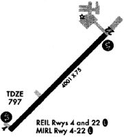
| Runways: | 04/22 |
| Longest Runway: | 04/22 is 5506 ft (1678 m) long |
| Runways with an Instrument Approach: |
KCFJ Airport Runway Details
| Runway 04/22 | 5506 ft x 75 ft (1678 m x 23 m) | |
| Runway Length Source: | 3RD PARTY SURVEY as of 12/10/2021 | |
| Surface: | Asphalt - Good condition - Saw-cut or plastic grooved | |
| Runway Edge Lights: | Medium Intensity | |
Runway Weight Bearing Capacity (in thousands of pounds) |
||
| Single Wheel Landing Gear: | 16.0 | |
| Dual Wheel Landing Gear: | 25.0 | |
Runway 04 |
Runway 22 |
|
Elevation: |
797.2 | 800.4 |
Latitude: |
39-58-08.7224N | 39-58-48.5755N |
Longitude: |
086-55-39.9466W | 086-54-51.7890W |
|
Runway True Alignment: |
043 | 223 |
Glide Path Angle: |
3.0 degrees | 3.0 degrees |
Traffic Pattern: |
Left | Left |
Runway Markings Type: |
Nonprecision Instrument | Nonprecision Instrument |
Runway Markings Condition: |
Good | Good |
Object at End: |
CROPS | ROAD |
Object Height: |
10 | 15 |
Distance from End: |
360 | 324 |
Object Centerline Offset: |
0 ft. left and right of centerline | 280 ft. right of centerline |
Visual Glide Slope Indicators: |
4-Light PAPI On Left Side Of Runway | 4-Light PAPI On Left Side Of Runway |
REIL: |
Yes | Yes |
Touchdown Lights: |
No | No |
Centerline Lights: |
No | No |
Threshold Crossing Height: |
41 | 42 |
Threshold Elevation: |
799.4 | |
Displaced Threshold: |
502 | |
Threshold Latitude: |
39-58-44.9329N | |
Threshold Longitude: |
086-54-56.1917W |
Services
Airframe Repair: |
Minor |
Powerplant Repair: |
Minor |
Fuel Available: |
100LL, Jet A |
Landing Fees: |
No |
Parking: |
Hangars and tiedowns available |
Maps & Diagrams
KCFJ Sectional
Flight Planning
at skyvector.com
at skyvector.com