Location
Latitude: |
36-59-14.0000N (36.987222) |
Longitude: |
077-00-04.1000W (-77.001139) |
Elevation: |
111.4 feet MSL (34 m MSL) |
Magnetic Variation: |
10.5 W (as of April 2024 from WMM2020 model) |
Time Zone: |
UTC -5.0 (Standard Time) UTC -4.0 (Daylight Savings Time) |
From City: |
02 N.M. NW of Wakefield, Virginia |
Found On: |
Washington Chart |
FAA Region: |
AEA |
Contacts
Manager: |
Publicly owned: |
| BRIAN LAINE P.O. BOX 550 WAKEFIELD, VA 23888 757-899-0096 |
TOWN OF WAKEFIELD P O BOX 550 WAKEFIELD, VA 23888 757-899-2030 |
Operations
Airport Status: |
Operational |
Facility Use: |
Public |
Type: |
Airport |
Activation Date: |
06/1967 |
Control tower: |
No |
Attendance (Months/Days/Hours): |
Months/Days/Hours IREG |
Boundary ARTCC: |
ZDC (Washington) |
Responsible ARTCC: |
ZDC (Washington) |
Segmented Circle Indicator: |
Yes |
Traffic Pattern Altitude (MSL): |
1111 feet (339 m) |
NOTAMs Facility: |
AKQ |
NOTAM-D Service: |
Yes |
International Airport of Entry: |
No |
Customs Landing Rights: |
No |
Military Landing Rights: |
No |
Civil/Military Joint Use: |
No |
Based Aircraft
| Single Engine: | 24 |
| Gliders: | 1 |
Annual Operations (as of 07/31/2023)
| Total Operations: | 24771 | |
| Air Taxi: | 495 | 2.0% |
| GA Local: | 12633 | 51.0% |
| GA Itinerant: | 8918 | 36.0% |
| Military Aircraft: | 2725 | 11.0% |
Communications
| CTAF: | 122.800 |
| Unicom: | 122.800 |
| Approach: | NORFOLK 127.9 127.9 |
| Departure: | NORFOLK 127.9 127.9 |
| ASOS: | 128.325 (757-899-2300) |
Fixed Based Operators (FBOs) & Fuel
(Click on a business for detail)
Please help us keep this information up to date. This is a FREE SERVICE just like everything else on Airport Guide! If you see that a business needs to be added, modified, or deleted please fill out our Update Form.
To add, modify, or delete a business click here.
Please help us keep this information up to date. This is a FREE SERVICE just like everything else on Airport Guide! If you see that a business needs to be added, modified, or deleted please fill out our Update Form.
Area Code: 757 |
| Business Name | Frequency | Phone | Fuel Grade |
|---|
Flight Service Stations
| Primary | Alternate | |
| FSS on Field: | N | |
| FSS Name (ID): | Leesburg(DCA) | |
| Frequency: | ||
| Toll Free Phone: | 1-800-WX-BRIEF |
Instrument Procedures / Charts
FAA Terminal Procedures valid from 0901Z 03/21/24 to 0901Z 04/18/24.
There are various types of charts available for an airport. They are listed in the Page Type column. Here is a legend for those types:
APD - Airport Diagram
DP - Departure Procedure Charts
HOT - Hot Spots
IAP - Instrument Approach Procedure Charts
MIN - Minimums
STAR - Standard Terminal Arrival Charts
| Page Type | Page Name | Volume | Action Since Last Cycle |
|---|---|---|---|
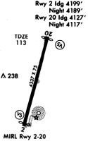
| IAP | NDB RWY 20 | NE-3 | |
| IAP | RNAV (GPS) RWY 20 | NE-3 | |
| MIN | ALTERNATE MINIMUMS | NE-3 | |
| MIN | TAKEOFF MINIMUMS | NE-3 |
Terminal Procedures are only available for airports in several countries with more being added all the time. If you are looking for a specific country's charts, please send an email to support(at)airportguide.com stating the country name. This will be used to prioritize the implementation.
Navigation Aids (Navaids) near KAKQ
| Dist (NM) | ID | Morse Code | Name | Type | Freq | True Hdg | Mag Hdg |
|---|---|---|---|---|---|---|---|
| 0.3 | AKQ | . _ _ . _ _ _ . _ | Wakefield | NDB | 274 | 178 | 189 |
| 16.4 | FKN | . . _ . _ . _ _ . | Franklin | VORTAC | 110.60 | 181 | 191 |
| 20.4 | FAF | . . _ . . _ . . _ . | Felker | NDB | 226 | 63 | 74 |
| 21.2 | HPW | . . . . . _ _ . . _ _ | Hopewell | VORTAC | 112.00 | 345 | 356 |
| 25.8 | PJS | . _ _ . . _ _ _ . . . | Henry | NDB | 375 | 70 | 81 |
| 28.8 | RK | . _ . _ . _ | Waley | NDB | 249 | 143 | 154 |
| 30.0 | CF | _ . _ . . . _ . | Pubbs | NDB | 392 | 313 | 323 |
| 30.1 | ELQ | . . _ . . _ _ . _ | Emporia | NDB | 261 | 222 | 232 |
| 31.0 | HCM | . . . . _ . _ . _ _ | Harcum | VORTAC | 108.80 | 26 | 37 |
| 31.3 | LFI | . _ . . . . _ . . . | Langley | TACAN | 112.30 | 78 | 89 |
| 34.5 | RIC | . _ . . . _ . _ . | Richmond | VORTAC | 114.10 | 333 | 343 |
| 34.8 | NGU | _ . _ _ . . . _ | Chambers | TACAN | 113.95 | 94 | 105 |
| 37.0 | OR | _ _ _ . _ . | Ingle | NDB | 329 | 103 | 114 |
| 37.4 | CVI | _ . _ . . . . _ . . | Cofield | VORTAC | 114.60 | 170 | 180 |
| 37.8 | EY | . _ . _ _ | Chesi | NDB | 233 | 127 | 138 |
| 38.8 | ORF | _ _ _ . _ . . . _ . | Norfolk | VORTAC | 116.90 | 98 | 109 |
| 44.4 | LVL | . _ . . . . . _ . _ . . | Lawrenceville | VORTAC | 112.90 | 257 | 267 |
| 47.2 | RZZ | . _ . _ _ . . _ _ . . | Rapids | NDB | 407 | 226 | 236 |
| 47.3 | NTU | _ . _ . . _ | Oceana | TACAN | 116.60 | 101 | 112 |
| 50.7 | BKT | _ . . . _ . _ _ | Blackstone | NDB | 326 | 279 | 289 |
Nearby Airports with Fuel
Notices to Airmen (NOTAMS)
Remarks
| A110-2 | FOR CD CTC NORFOLK APCH AT 757-464-0757. |
| A42-02 | RWY 2 MRKGS CVRD WITH ALGAE. |
| A42-20 | RWY 20 MRKGS CVRD WITH ALGAE. |
| A57-02 | CTLNG OBSTN EXCEEDS A 45 DEG SLP, CLNC SLP TO DSPLCD THLD 8:1. |
| A57-20 | CLNC SLP TO DSPLCD THLD 22:1. |
| A58-02 | RD +15' 70' FM THR CROSSING END. |
| A58-20 | ROAD +15 FT 70 FT FM RY END. |
| A70-FUEL-10 | 0LL 24 HR SELF SERVICE FUEL |
Runways
Runway Summary
| Runways: | 02/20 |
| Longest Runway: | 02/20 is 4337 ft (1322 m) long |
| Runways with an Instrument Approach: |
KAKQ Airport Runway Details
| Runway 02/20 | 4337 ft x 75 ft (1322 m x 23 m) | |
| Runway Length Source: | 3RD PARTY SURVEY as of 01/13/2010 | |
| Surface: | Asphalt - Fair condition - No special surface treatment | |
| Runway Edge Lights: | Medium Intensity | |
Runway Weight Bearing Capacity (in thousands of pounds) |
||
| Single Wheel Landing Gear: | 12.5 | |
Runway 02 |
Runway 20 |
|
Elevation: |
107.4 | 111.4 |
Latitude: |
36-58-53.4502N | 36-59-34.4821N |
Longitude: |
077-00-11.8278W | 076-59-56.2996W |
|
Runway True Alignment: |
017 | 197 |
Glide Path Angle: |
0.0 degrees | 0.0 degrees |
Traffic Pattern: |
Left | Left |
Runway Markings Type: |
Nonprecision Instrument | Nonprecision Instrument |
Runway Markings Condition: |
Poor | Poor |
Object at End: |
TREES | TREES |
Object Height: |
28 | 62 |
Distance from End: |
201 | 1154 |
Object Centerline Offset: |
52 ft. left of centerline | 34 ft. right of centerline |
REIL: |
No | No |
Threshold Elevation: |
106.9 | 109.9 |
Displaced Threshold: |
298 | 471 |
Threshold Latitude: |
36-58-56.2676N | 36-59-30.0309N |
Threshold Longitude: |
077-00-10.7541W | 076-59-57.9861W |
Services
Airframe Repair: |
Major |
Powerplant Repair: |
Major |
Bottled Oxygen: |
None |
Bulk Oxygen: |
None |
Fuel Available: |
100LL, Jet A+ |
Landing Fees: |
No |
Parking: |
Hangars and tiedowns available |
Maps & Diagrams
KAKQ Sectional
Flight Planning
at skyvector.com
at skyvector.com