Location
Latitude: |
37-09-33.8000N (37.159389) |
Longitude: |
095-02-29.4000W (-95.0415) |
Elevation: |
832.0 feet MSL (254 m MSL) |
Magnetic Variation: |
1.5 E (as of April 2024 from WMM2020 model) |
Time Zone: |
UTC -6.0 (Standard Time) UTC -5.0 (Daylight Savings Time) |
From City: |
03 N.M. E of Oswego, Kansas |
Found On: |
Kansas City Chart |
FAA Region: |
ACE |
Contacts
Manager: |
Publicly owned: |
| CALVIN JURGENSEN PO BOX 210 OSWEGO, KS 67356 (620) 429-0297 |
CITY OF OSWEGO 703 5TH ST OSWEGO, KS 67356 620-795-4433 |
Operations
Airport Status: |
Operational |
Facility Use: |
Public |
Type: |
Airport |
Activation Date: |
08/1961 |
Control tower: |
No |
Attendance (Months/Days/Hours): |
Months/Days/Hours Unattended |
Boundary ARTCC: |
ZKC (Kansas City) |
Responsible ARTCC: |
ZKC (Kansas City) |
Segmented Circle Indicator: |
No |
Traffic Pattern Altitude (MSL): |
1832 feet (558 m) |
NOTAMs Facility: |
ICT |
NOTAM-D Service: |
Yes |
International Airport of Entry: |
No |
Customs Landing Rights: |
No |
Military Landing Rights: |
Yes |
Civil/Military Joint Use: |
No |
Based Aircraft
| Single Engine: | 4 |
Annual Operations (as of 08/02/2018)
| Total Operations: | 550 | |
| GA Local: | 400 | 72.7% |
| GA Itinerant: | 150 | 27.3% |
Communications
| CTAF: | 122.900 |
Fixed Based Operators (FBOs) & Fuel
(Click on a business for detail)
Please help us keep this information up to date. This is a FREE SERVICE just like everything else on Airport Guide! If you see that a business needs to be added, modified, or deleted please fill out our Update Form.
To add, modify, or delete a business click here.
Please help us keep this information up to date. This is a FREE SERVICE just like everything else on Airport Guide! If you see that a business needs to be added, modified, or deleted please fill out our Update Form.
Area Code: 620 |
| Business Name | Frequency | Phone | Fuel Grade |
|---|
Flight Service Stations
| Primary | Alternate | |
| FSS on Field: | N | |
| FSS Name (ID): | Wichita(ICT) | |
| Frequency: | ||
| Toll Free Phone: | 1-800-WX-BRIEF |
Instrument Procedures / Charts
Terminal Procedures are only available for airports in several countries with more being added all the time. If you are looking for a specific country's charts, please send an email to support(at)airportguide.com stating the country name. This will be used to prioritize the implementation.
Navigation Aids (Navaids) near K67
| Dist (NM) | ID | Morse Code | Name | Type | Freq | True Hdg | Mag Hdg |
|---|---|---|---|---|---|---|---|
| 7.8 | OSW | _ _ _ . . . . _ _ | Oswego | DME | 117.6 | 269 | 267 |
| 22.7 | PTS | . _ _ . _ . . . | Pittsburg | NDB | 365 | 41 | 40 |
| 23.2 | JL | . _ _ _ . _ . . | Lunns | NDB | 344 | 83 | 82 |
| 25.7 | CFV | _ . _ . . . _ . . . . _ | Coffeyville | NDB | 212 | 261 | 259 |
| 34.7 | EOS | . _ _ _ . . . | Neosho | DME | 117.3 | 123 | 122 |
| 38.4 | CNU | _ . _ . _ . . . _ | Chanute | VOR-DME | 109.20 | 316 | 314 |
| 40.1 | LLU | . _ . . . _ . . . . _ | Spring River | NDB | 356 | 60 | 59 |
| 40.4 | FSK | . . _ . . . . _ . _ | Fort Scott | NDB | 379 | 18 | 17 |
| 41.9 | MSB | _ _ . . . _ . . . | Monarch | NDB | 410 | 334 | 332 |
| 50.4 | BV | _ . . . . . . _ | Dewie | NDB | 201 | 247 | 245 |
| 50.7 | BVO | _ . . . . . . _ _ _ _ | Bartlesville | VOR-DME | 117.90 | 247 | 245 |
| 62.7 | RO | . _ . _ _ _ | Rogrs | NDB | 263 | 131 | 130 |
| 64.0 | SLG | . . . . _ . . _ _ . | Siloam Springs | NDB | 284 | 155 | 154 |
| 68.0 | TUL | _ . . _ . _ . . | Tulsa | VORTAC | 114.40 | 212 | 210 |
| 70.4 | TUL | _ . . _ . _ . . | Tulsa Intl | VOT | 109.00 | 215 | 213 |
| 70.4 | RZC | . _ . _ _ . . _ . _ . | Razorback | VORTAC | 116.40 | 140 | 139 |
| 71.7 | BUM | _ . . . . . _ _ _ | Butler | VORTAC | 115.90 | 21 | 20 |
| 74.0 | TQH | _ _ _ . _ . . . . | Tahlequah | NDB | 215 | 178 | 177 |
| 75.7 | UKL | . . _ _ . _ . _ . . | Boyd | NDB | 245 | 334 | 332 |
| 75.7 | TU | _ . . _ | Oillr | NDB | 338 | 212 | 210 |
Nearby Airports with Fuel
Notices to Airmen (NOTAMS)
Remarks
| A110-2 | PUBLIC PHONE. |
| A110-3 | WILDLIFE ON & INVOF ARPT. |
| A110-4 | FOR CD CTC KANSAS CITY ARTCC AT 913-254-8508. |
| A70-FUEL-10 | 0LL SELF SVC FUEL AVBL 24HRS |
Runways
Runway Summary
| Runways: | 17/35 |
| Longest Runway: | 17/35 is 2500 ft (762 m) long |
| Runways with an Instrument Approach: |
K67 Airport Runway Details
| Runway 17/35 | 2500 ft x 50 ft (762 m x 15 m) | |
| Surface: | Asphalt - Good condition - No special surface treatment | |
| Runway Pavement Class: | 4 /F/C/Y/U | |
| Runway Edge Lights: | Low Intensity | |
Runway 17 |
Runway 35 |
|
Elevation: |
832.0 | 826.0 |
Latitude: |
37-09-46.1314N | 37-09-21.4072N |
Longitude: |
095-02-29.4008W | 095-02-29.4008W |
|
Runway True Alignment: |
180 | 000 |
Glide Path Angle: |
0.0 degrees | 0.0 degrees |
Traffic Pattern: |
Left | Left |
Runway Markings Type: |
Basic | Basic |
Runway Markings Condition: |
Good | Good |
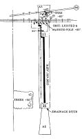
Object at End: |
RR | |
Object Height: |
23 | |
Distance from End: |
660 | |
Object Centerline Offset: |
0 ft. left and right of centerline |
Services
Airframe Repair: |
None |
Powerplant Repair: |
None |
Bottled Oxygen: |
None |
Bulk Oxygen: |
None |
Fuel Available: |
100LL, MOGAS |
Maps & Diagrams
K67 Sectional
Flight Planning
at skyvector.com
at skyvector.com