Location
Latitude: |
58-21-16.9625N (58.354712) |
Longitude: |
134-34-42.4939W (-134.57847) |
Elevation: |
25.3 feet MSL (8 m MSL) |
Magnetic Variation: |
18.2 E (as of April 2024 from WMM2020 model) |
Time Zone: |
UTC -9.0 (Standard Time) UTC -8.0 (Daylight Savings Time) |
From City: |
07 N.M. NW of Juneau, Alaska |
Found On: |
Juneau Chart |
FAA Region: |
AAL |
Contacts
Manager: |
Publicly owned: |
| PATTY WAHTO 1873 SHELL SIMMONS DR, SUITE 200 JUNEAU, AK 99801 907-789-7821 |
CITY OF JUNEAU 155 S SEWARD JUNEAU, AK 99801 907-789-7821 |
Operations
Airport Status: |
Operational |
Facility Use: |
Public |
Type: |
Airport |
Activation Date: |
11/1941 |
Control tower: |
Yes |
Attendance (Months/Days/Hours): |
Months/Days/Hours ALL/ALL/ALL |
Boundary ARTCC: |
ZAN (Anchorage) |
Responsible ARTCC: |
ZAN (Anchorage) |
Lighting Schedule: |
SEE RMK |
Segmented Circle Indicator: |
Yes |
Traffic Pattern Altitude (MSL): |
1025 feet (312 m) |
NOTAMs Facility: |
JNU |
NOTAM-D Service: |
Yes |
International Airport of Entry: |
Yes |
Customs Landing Rights: |
No |
Military Landing Rights: |
Yes |
Civil/Military Joint Use: |
No |
Aircraft Rescue and Firefighting: |
Class I ARFF Index: C Air Carrier Service: Scheduled Certification Date: 04/2005 |
Based Aircraft
| Single Engine: | 239 |
| Multi Engine: | 4 |
| Jet Engine: | 1 |
| GA Helicopters: | 28 |
| Military Aircraft: | 3 |
Annual Operations (as of 12/31/2022)
| Total Operations: | 94585 | |
| Commercial: | 8854 | 9.4% |
| Air Taxi: | 75127 | 79.4% |
| GA Local: | 2330 | 2.5% |
| GA Itinerant: | 7952 | 8.4% |
| Military Aircraft: | 322 | 0.3% |
Communications
| CTAF: | 118.700 |
| Unicom: | 122.950 |
| Tower: | JUNEAU 118.7 278.3 120.7 ;SEASONAL USE ONLY Hrs: 1 APR - SEP 30 0600 - 2300, 1 OCT - MAR 31, 0700 - 2000. |
| Clearance Del.: | 121.9 |
| Ground: | 121.9 |
| Approach: | ANCHORAGE ARTCC |
| Departure: | ANCHORAGE ARTCC |
| ATIS: | 135.2 Hrs: 24 |
| ASOS: | (907-789-1243) |
| NG OPS: | 124.65 |
| NG OPS: | 64.7 |
- APCH/DEP SVC PRVDD BY ANCHORAGE ARTCC ON FREQ 133.9 (MOUNT ROBERT BARRON RCAG).
- JUNEAU INTL SEAPLANE BASIN CONTACT JUNEAU TWR ON FREQ 118.7 FOR TAXI; TAKE-OFF; AND LANDING INSTRUCTIONS. WATERLANE CONTROLLED BY JUNEAU ATCT. TAXING ACFT SHOULD TAXI CLOCKWISE AROUND THE OUTER EDGE OF FLOAT POND.
- BTN MAY & SEP AN ADDITIONAL LC FREQ OF 120.7 WILL BE IN USE. ITS USE WILL BE ANNOUNCED VIA THE ATIS. ALL OTR TIME USE 118.7 AS LC.
- CTC JUNEAU FSS ON 118.7 FOR ADVISORY SVC WHEN JNU TWR CLSD.
- COMMUNICATIONS PRVDD BY JUNEAU FSS ON FREQ 122.2.
Fixed Based Operators (FBOs) & Fuel
(Click on a business for detail)
Please help us keep this information up to date. This is a FREE SERVICE just like everything else on Airport Guide! If you see that a business needs to be added, modified, or deleted please fill out our Update Form.
To add, modify, or delete a business click here.
Please help us keep this information up to date. This is a FREE SERVICE just like everything else on Airport Guide! If you see that a business needs to be added, modified, or deleted please fill out our Update Form.
Area Code: 907 |
| Business Name | Frequency | Phone | Fuel Grade |
|---|---|---|---|
| Aero Services, Inc.
Website Update FBO info |
Unicom 122.95 | 789-0055, 888-286-3835 | 80, 100LL, Jet A |
| Coastal Fuel
Update FBO info |
Arinc 123.5 | 789-5600 | 100LL, Jet A |
| Juneau Flight School
Website Update FBO info |
790-4390 | ||
| Wings of Alaska
Update FBO info |
789-0790 |
Flight Service Stations
| Primary | Alternate | |
| FSS on Field: | Y | |
| FSS Name (ID): | Juneau(JNU) | |
| Frequency: | ||
| Toll Free Phone: | 1-866-297-2236 |
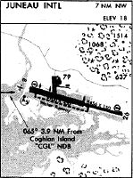
Instrument Procedures / Charts
FAA Terminal Procedures valid from 0901Z 03/21/24 to 0901Z 04/18/24.
There are various types of charts available for an airport. They are listed in the Page Type column. Here is a legend for those types:
APD - Airport Diagram
DP - Departure Procedure Charts
HOT - Hot Spots
IAP - Instrument Approach Procedure Charts
MIN - Minimums
STAR - Standard Terminal Arrival Charts
| Page Type | Page Name | Volume | Action Since Last Cycle |
|---|---|---|---|
| APD | AIRPORT DIAGRAM | AK-1 | |
| DP | ASORT TWO | AK-1 | |
| IAP | LDA X RWY 08 | AK-1 | |
| IAP | RNAV (GPS) V RWY 08 | AK-1 | |
| MIN | ALTERNATE MINIMUMS | AK-1 | |
| MIN | TAKEOFF MINIMUMS | AK-1 | |
| ODP | JUNEAU SIX (OBSTACLE) | AK-1 | |
| ODP | JUNEAU SIX (OBSTACLE)[DELIMITER] CONT.1 | AK-1 |
Terminal Procedures are only available for airports in several countries with more being added all the time. If you are looking for a specific country's charts, please send an email to support(at)airportguide.com stating the country name. This will be used to prioritize the implementation.
Navigation Aids (Navaids) near JNU
| Dist (NM) | ID | Morse Code | Name | Type | Freq | True Hdg | Mag Hdg |
|---|---|---|---|---|---|---|---|
| 1.7 | JNU | . _ _ _ _ . . . _ | Juneau | VOT | 111.00 | 278 | 260 |
| 3.8 | CGL | _ . _ . _ _ . . _ . . | Coghlan Island | NDB | 212 | 274 | 256 |
| 15.9 | JDL | . _ _ _ _ . . . _ . . | Lynns | FAN MARKER | 271 | 253 | |
| 24.0 | SSR | . . . . . . . _ . | Sisters Island | VORTAC | 114.00 | 243 | 225 |
| 24.1 | EEF | . . . . _ . | Elephant | NDB | 391 | 243 | 225 |
| 35.7 | GAV | _ _ . . _ . . . _ | Gustavus | NDB | 219 | 276 | 258 |
| 57.9 | HNS | . . . . _ . . . . | Haines | NDB | 245 | 333 | 315 |
| 75.5 | 3P | Muddy Lake | NDB | 242 | 94 | 76 | |
| 82.4 | IME | . . _ _ . | Mount Edgecumbe | NDB | 414 | 198 | 180 |
| 86.1 | AFE | . _ . . _ . . | Kake | NDB-DME | 223 | 165 | 147 |
| 95.0 | BKA | _ . . . _ . _ . _ | Biorka Island | VORTAC | 113.80 | 199 | 181 |
| 95.1 | SIT | . . . . . _ | Sitka | NDB | 358 | 199 | 181 |
Nearby Airports with Fuel
| Dist (NM) | Name (Airport IDs) | True Hdg | Mag Hdg | Fuel Grade |
|---|---|---|---|---|
| 35.8 | Gustavus Airport (GST PAGS GST) |
277 | 259 | Jet A |
| 60.9 | Haines Airport (HNS PAHN HNS) |
331 | 313 | 100LL, Jet A |
| 70.2 | Skagway Airport (SGY PAGY SGY) |
341 | 323 | 100LL |
| 82.4 | Sitka Rocky Gutierrez Airport (SIT PASI SIT) |
198 | 180 | 100, Jet A-1+ |
| 89.1 | Saginaw Seaplane Base (SGW A23) |
171 | 153 | 100LL |
Notices to Airmen (NOTAMS)
Remarks
| A110-10 | FOR LCL CALL TO JUNEAU FSS CALL 907-789-7380. |
| A110-11 | TRANSIENT DOCK AVBL FOR PUBLIC USE FOR UP TO SIX ACFT, SW CORNER. |
| A110-13 | SEE SPECIAL NOTICES AND GENERAL NOTICES FOR ADDITIONAL INFORMATION ON OPNS IN JUNEAU AREA. |
| A110-15 | LENA POINT, PEDERSON HILL AND SISTERS ISLAND WX CAMERAS AVBL ON INTERNET AT HTTPS://WEATHERCAMS.FAA.GOV |
| A110-19 | RY 08/26 SAND USED TO ENHANCE RY FRICTION MAY NOT MEET FAA SPECS. |
| A110-20 | COLD TEMPERATURE AIRPORT. ALTITUDE CORRECTION REQUIRED AT OR BELOW -0C. |
| A110-21 | APRON TERMINAL RAMP CLSD TO ROTORCRAFT. APRON US CUSTOMS RAMP CLSD TO ACFT WITH WINGSPAN MORE THAN 79 FT INTL ACFT WITH WINGSPAN MORE THAN 79 FT AND ALL INTL ROTORCRAFT USE E-1 RAMP (NTL GUARD RAMP). |
| A110-3 | NATIONAL GUARD 24 HR PPR DUE TO LIMITED PARKING C907-789-3366. 0730-1600 WEEKDAYS CONTACT GUARD OPS 10 MIN PRIOR TO LANDING ON 124.65. |
| A110-4 | WILDLIFE & BIRDS ON & INVOF ARPT. |
| A110-5 | BATTLESHIP ISLAND RLLS GROUPING; CENTER LIGHT 582132.88N 1344012.22W. IJDL-LOCALIZER RLLS GROUPING; CENTER LIGHT 582132.02N 1343810.39W. |
| A110-6 | INCREASED HELICOPTER/LIGH ACFT ACTIVITY APR 15-OCT 1 ENTIRE LENGTH ON GASTINEAU CHANNEL & WITHIN 5 MILES OF ARPT. |
| A110-7 | PARAGLIDING ACTIVITY 3 MILES N OF ARPT INVOF THUNDER MOUNTAIN & OVER GASTINEAU CHANNEL NEARS DOWNTOWN APR 15-OCT 1 6000 FT & BLO. |
| A110-9 | TPA 1500 AGL FOR LARGE TURBINE ACFT; 1000 FT AGL FOR FIXED WING ACFT; 500 FT AGL FOR HELICOPTERS. |
| A43-08 | VASI ALIGNED APRXLY 13 DEGS RIGHT OF RY CNTRLN AND IS NOT VISIBLE ON RY CNTRL. VASI UNUSBL BYD 06 DEGS LEFT OF CRS. |
| A43-26 | RY 26 PAPI UNUSBL BYD 2 NM DUE TO TERRAIN. |
| A49-08 | RLLS LGTS: ( JNUB BATTLESHIP ISLAND, JNUA ENGINEERS CUT, JNU WETLANDS/FLATS) |
| A49-26 | RY 26 MALS NSTD; LENGTH 800 FT. |
| A70-FUEL-10 | 0LL FUEL AVBL THRU ARPT SVCS ON UNICOM OR 907-789-0055 OR 907-789-5622. |
| A71 | AIRFRAME/POWER PLANT SVC FOR SINGLE/TWIN PROP ENG ACFT TURBIN & AVIONICS. |
| A81-APT | FOR HIRL RWY 08/26, MALSF RWY 08 & REIL RWY 26 CTC JNU ATCT ON FREQ 118.7. WHEN ATCT CLSD CTC JNU FSS ON FREQ 118.7. VASI RWY 08 & PAPI RWY 26 OPER 24 HRS. |
| A86 | CTC JUNEAU FSS FOR AIRPORT ADVISORY SERVICE ON 118.7 WHEN TOWER IS CLSD. |
Runways
Runway Summary
| Runways: | 08/26 08W/26W |
| Longest Runway: | 08/26 is 8857 ft (2700 m) long |
| Runways with an Instrument Approach: | 08 |
JNU Seaplane Base Runway Details
| Runway 08/26 | 8857 ft x 150 ft (2700 m x 46 m) | |
| Runway Length Source: | FAA as of 12/30/2013 | |
| Surface: | Asphalt - Good condition - Saw-cut or plastic grooved | |
| Runway Pavement Class: | 89 /F/C/X/T | |
| Runway Edge Lights: | High Intensity | |
Runway Weight Bearing Capacity (in thousands of pounds) |
||
| Single Wheel Landing Gear: | 120.0 | |
| Dual Wheel Landing Gear: | 250.0 | |
| Dual Tandem Wheel Landing Gear: | 550.0 | |
Runway 08 |
Runway 26 |
|
Elevation: |
25.0 | 23.4 |
Latitude: |
58-21-28.2500N | 58-21-05.8800N |
Longitude: |
134-35-49.0900W | 134-33-08.6300W |
|
Runway True Alignment: |
105 | 285 |
ILS Type: |
LDA/DME | |
Glide Path Angle: |
3.5 degrees | 3.5 degrees |
Traffic Pattern: |
Right | Left |
Runway Markings Type: |
Nonprecision Instrument | Nonprecision Instrument |
Runway Markings Condition: |
Fair | Fair |
Object at End: |
TOWER | |
Object Height: |
573 | |
Distance from End: |
7600 | |
Object Centerline Offset: |
900 ft. left of centerline | |
Visual Glide Slope Indicators: |
2-Box VASI On Left Side Of Runway | 4-Light PAPI On Left Side Of Runway |
Runway Visual Range (RVR): |
Touchdown, Rollout | Touchdown, Rollout |
Approach Light System: |
1,400 Foot Medium Intensity Approach Lighting System With Sequenced Flashers | 1,400 Foot Medium Intensity Approach Lighting System |
REIL: |
Yes | Yes |
Touchdown Lights: |
No | No |
Centerline Lights: |
Yes | Yes |
Threshold Crossing Height: |
38 | 46 |
Declared Distances |
||
Take Off Run Avbl. (TORA): |
8857 | 8857 |
Take Off Distance Avbl. (TODA): |
8857 | 8857 |
Actual Stop Dist. Avbl. (ASDA): |
8457 | 8457 |
Landing Dist. Avbl. (LDA): |
8457 | 8457 |
| Runway 08W/26W | 4800 ft x 150 ft (1463 m x 46 m) | |
| Runway Length Source: | OWNER as of 04/22/2015 | |
| Surface: | Asphalt - Good condition - No special surface treatment | |
Runway 08W |
Runway 26W |
|
Latitude: |
58-21-22.8200N | 58-21-10.7100N |
Longitude: |
134-35-52.2300W | 134-34-25.2600W |
Glide Path Angle: |
0.0 degrees | 0.0 degrees |
Object Centerline Offset: |
900 ft. left of centerline |
Services
Fuel Available: |
100LL |
Landing Fees: |
No |
Maps & Diagrams
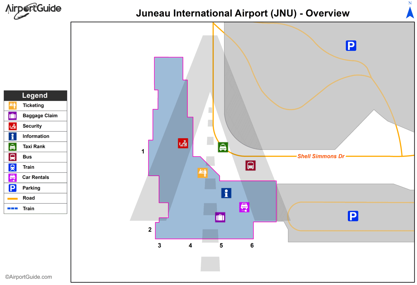
JNU Sectional
Flight Planning
at skyvector.com
at skyvector.com