Location
Latitude: |
45-08-36.6880N (45.143524) |
Longitude: |
114-55-44.3630W (-114.92899) |
Elevation: |
4289.0 feet MSL (1307 m MSL) |
Magnetic Variation: |
12.8 E (as of April 2024 from WMM2020 model) |
Time Zone: |
UTC -7.0 (Standard Time) UTC -6.0 (Daylight Savings Time) |
From City: |
17 N.M. E of Big Creek Ranger Station, Idaho |
Found On: |
Great Falls Chart |
FAA Region: |
ANM |
Contacts
Manager: |
Publicly owned: |
| KRASSEL DISTRICT RANGER 500 NORTH MISSION STREET MC CALL, ID 83638 208-634-0600 |
U S FOREST SERVICE 324 25TH ST OGDEN, UT 84401 801-625-5511 |
Operations
Airport Status: |
Operational |
Facility Use: |
Public |
Type: |
Airport |
Activation Date: |
07/1989 |
Control tower: |
No |
Attendance (Months/Days/Hours): |
Months/Days/Hours Unattended |
Boundary ARTCC: |
ZLC (Salt Lake City) |
Responsible ARTCC: |
ZLC (Salt Lake City) |
Segmented Circle Indicator: |
No |
Traffic Pattern Altitude (MSL): |
5289 feet (1612 m) |
NOTAMs Facility: |
BOI |
NOTAM-D Service: |
Yes |
Based Aircraft
Annual Operations (as of 06/30/2023)
| Total Operations: | 900 | |
| Air Taxi: | 600 | 66.7% |
| GA Itinerant: | 300 | 33.3% |
Communications
| CTAF: | 122.900 |
Fixed Based Operators (FBOs) & Fuel
(Click on a business for detail)
Please help us keep this information up to date. This is a FREE SERVICE just like everything else on Airport Guide! If you see that a business needs to be added, modified, or deleted please fill out our Update Form.
To add, modify, or delete a business click here.
Please help us keep this information up to date. This is a FREE SERVICE just like everything else on Airport Guide! If you see that a business needs to be added, modified, or deleted please fill out our Update Form.
Area Code: 208 |
| Business Name | Frequency | Phone | Fuel Grade |
|---|
Flight Service Stations
| Primary | Alternate | |
| FSS on Field: | ||
| FSS Name (ID): | Boise(BOI) | |
| Frequency: | ||
| Toll Free Phone: | 1-800-WX-BRIEF |
Instrument Procedures / Charts
Terminal Procedures are only available for airports in several countries with more being added all the time. If you are looking for a specific country's charts, please send an email to support(at)airportguide.com stating the country name. This will be used to prioritize the implementation.
Navigation Aids (Navaids) near I08
| Dist (NM) | ID | Morse Code | Name | Type | Freq | True Hdg | Mag Hdg |
|---|---|---|---|---|---|---|---|
| 36.5 | LKT | . _ . . _ . _ _ | Salmon | VOR-DME | 113.50 | 101 | 88 |
| 58.7 | DNJ | _ . . _ . . _ _ _ | Donnelly | VOR-DME | 116.20 | 247 | 234 |
| 84.9 | IDQ | . . _ . . _ _ . _ | Cottonwood | DME | 115.65 | 311 | 298 |
Nearby Airports with Fuel
| Dist (NM) | Name (Airport IDs) | True Hdg | Mag Hdg | Fuel Grade |
|---|---|---|---|---|
| 44.4 | Lemhi County Airport (SMN KSMN SMN) |
91 | 79 | 100, Jet A |
| 47.9 | Challis Airport (CHL KLLJ LLJ) |
140 | 128 | 100, Jet A |
| 52.0 | Mc Call Municipal Airport (MYL KMYL MYL) |
253 | 240 | 100LL, Jet A, Jet A-1+ |
| 52.5 | West Fork Lodge Airport (4U7) |
34 | 21 | Mogas |
| 56.1 | Stanley Airport (2U7) |
180 | 167 | 100LL |
| 60.5 | Cascade Airport (U70) |
230 | 217 | 100LL, Jet A |
| 68.6 | Council Municipal Airport (U82) |
250 | 237 | 100LL |
| 69.4 | Idaho County Airport (KGIC GIC) |
314 | 301 | 100LL, Jet A |
| 74.9 | Ravalli County Airport (HRF) |
26 | 13 | 100LL, Jet A, Jet A+ |
| 79.0 | Kamiah Municipal Airport (S73) |
325 | 312 | 100LL |
| 79.7 | Cottonwood Municipal Airport (S84) |
312 | 299 | 100LL |
| 90.6 | Stevensville Airport (32S) |
23 | 10 | 100LL |
| 92.8 | Craigmont Municipal Airport (S89) |
316 | 303 | 100LL |
| 98.6 | Orofino Municipal Airport (S68) |
325 | 312 | 100LL |
Notices to Airmen (NOTAMS)
Remarks
| A110-1 | LND RY 02; TKOF RY 20; GO AROUND NOT PSBL DUE TO HIGH TRRN AT END OF RY 20. |
| A110-2 | NO TELEPHONE AVBL AT ARPT. |
| A110-3 | RUBBER WATER DEFLECTION STRIPS ON RWY. |
| A110-4 | BIG GAME ANIMALS AND LIVESTOCK ON & INVOS RY. |
| A110-5 | FOR CD CTC SALT LAKE ARTCC AT 801-320-2568. |
| A31-02/20 | ACTUAL USBL RWY DIMENSIONS ARE: 1600 FT L X 15 FT W; FIRST 250 FT OF RWY END 02 IS VERY ROUGH, OVERGROWN WITH WEEDS & UNUSBL; NOT A STRAIGHT RWY, SLGTY CURVES TO THE NE. |
| A32-02/20 | 15 FT WIDE BARE DIRT STRIP DOWN CENTER OF RY. |
| A75 | TIE DOWN ANCHORS, NO CHAINS OR ROPES. |
Runways
Runway Summary
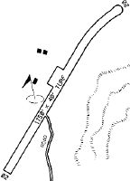
| Runways: | 02/20 |
| Longest Runway: | 02/20 is 1750 ft (533 m) long |
| Runways with an Instrument Approach: |
I08 Airport Runway Details
| Runway 02/20 | 1750 ft x 40 ft (533 m x 12 m) | |
| Surface: | Turf/Dirt - Fair condition - No special surface treatment | |
Runway 02 |
Runway 20 |
|
Glide Path Angle: |
0.0 degrees | 0.0 degrees |
Object at End: |
TREE | HILL |
Object Height: |
55 | 300 |
Distance from End: |
260 | 400 |
Object Centerline Offset: |
80 ft. right of centerline | 0 ft. left and right of centerline |
Services
Airframe Repair: |
None |
Powerplant Repair: |
None |
Bottled Oxygen: |
None |
Bulk Oxygen: |
None |
Fuel Available: |
100LL |
Landing Fees: |
No |
Parking: |
Tiedowns available |
Maps & Diagrams
I08 Sectional
Flight Planning
at skyvector.com
at skyvector.com