Location
Latitude: |
44-54-36.4000N (44.910111) |
Longitude: |
067-00-45.7000W (-67.012694) |
Elevation: |
45.3 feet MSL (14 m MSL) |
Magnetic Variation: |
15.9 W (as of April 2024 from WMM2020 model) |
Time Zone: |
UTC -5.0 (Standard Time) UTC -4.0 (Daylight Savings Time) |
From City: |
01 N.M. W of Eastport, Maine |
Found On: |
Halifax Chart |
FAA Region: |
ANE |
Contacts
Manager: |
Publicly owned: |
| PETE LEHMANN 1 AIRPORT RD EASTPORT, ME 04631 207-214-4751 |
CITY OF EASTPORT 22 WASHINGTON ST EASTPORT, ME 04631 207-853-2300 |
Operations
Airport Status: |
Operational |
Facility Use: |
Public |
Type: |
Airport |
Activation Date: |
12/1942 |
Control tower: |
No |
Attendance (Months/Days/Hours): |
Months/Days/Hours Unattended |
Boundary ARTCC: |
ZBW (Boston) |
Responsible ARTCC: |
ZBW (Boston) |
Lighting Schedule: |
SEE RMK |
Segmented Circle Indicator: |
No |
Traffic Pattern Altitude (MSL): |
1045 feet (319 m) |
NOTAMs Facility: |
EPM |
NOTAM-D Service: |
Yes |
International Airport of Entry: |
No |
Customs Landing Rights: |
Yes |
Military Landing Rights: |
Yes |
Civil/Military Joint Use: |
No |
Based Aircraft
| Single Engine: | 7 |
Annual Operations (as of 08/12/2022)
| Total Operations: | 6000 | |
| GA Local: | 2700 | 45.0% |
| GA Itinerant: | 1800 | 30.0% |
| Military Aircraft: | 1500 | 25.0% |
Communications
| CTAF: | 122.800 |
| Unicom: | 122.800 |
| AWOS-AV: | 122.8 (207-853-0682) |
- APCH/DEP SVC PRVDD BY BOSTON ARTCC ON FREQ 124.25/290.50 (BANGOR RCAG).
Fixed Based Operators (FBOs) & Fuel
(Click on a business for detail)
Please help us keep this information up to date. This is a FREE SERVICE just like everything else on Airport Guide! If you see that a business needs to be added, modified, or deleted please fill out our Update Form.
To add, modify, or delete a business click here.
Please help us keep this information up to date. This is a FREE SERVICE just like everything else on Airport Guide! If you see that a business needs to be added, modified, or deleted please fill out our Update Form.
Area Code: 207 |
| Business Name | Frequency | Phone | Fuel Grade |
|---|
Flight Service Stations
| Primary | Alternate | |
| FSS on Field: | N | |
| FSS Name (ID): | Bangor(BGR) | |
| Frequency: | ||
| Toll Free Phone: | 1-800-WX-BRIEF |
Instrument Procedures / Charts
FAA Terminal Procedures valid from 0901Z 03/21/24 to 0901Z 04/18/24.
There are various types of charts available for an airport. They are listed in the Page Type column. Here is a legend for those types:
APD - Airport Diagram
DP - Departure Procedure Charts
HOT - Hot Spots
IAP - Instrument Approach Procedure Charts
MIN - Minimums
STAR - Standard Terminal Arrival Charts
| Page Type | Page Name | Volume | Action Since Last Cycle |
|---|---|---|---|
| IAP | RNAV (GPS) RWY 15 | NE-1 | |
| IAP | RNAV (GPS) RWY 33 | NE-1 | |
| MIN | TAKEOFF MINIMUMS | NE-1 |
Terminal Procedures are only available for airports in several countries with more being added all the time. If you are looking for a specific country's charts, please send an email to support(at)airportguide.com stating the country name. This will be used to prioritize the implementation.
Navigation Aids (Navaids) near EPM
| Dist (NM) | ID | Morse Code | Name | Type | Freq | True Hdg | Mag Hdg |
|---|---|---|---|---|---|---|---|
| 0.1 | EPM | . . _ _ . _ _ | Eastport | NDB | 260 | 6 | 22 |
| 14.7 | 6E | Grand Manan | NDB | 387 | 142 | 158 | |
| 38.6 | PNN | . _ _ . _ . _ . | Princeton | DME | 114.3 | 310 | 326 |
| 48.6 | ZST | Alpine | NDB | 397 | 66 | 82 | |
| 56.5 | Y9 | Digby | NDB | 220 | 112 | 128 | |
| 56.8 | YSJ | _ . _ _ . . . . _ _ _ | Saint John | VOR-DME | 113.50 | 57 | 73 |
| 58.2 | SJ | Saint John | NDB | 212 | 59 | 75 | |
| 59.5 | BH | _ . . . . . . . | Surry | NDB | 330 | 248 | 264 |
| 60.4 | IDC | Fredericton | DME | 111.30 | 18 | 34 | |
| 62.9 | FC | Fredericton | NDB | 326 | 15 | 31 | |
| 64.2 | YFC | _ . _ _ . . _ . _ . _ . | Fredericton | VORTAC | 113.00 | 22 | 38 |
| 69.1 | OLD | _ _ _ . _ . . _ . . | Old Town | NDB | 272 | 275 | 291 |
| 75.3 | MLT | _ _ . _ . . _ | Millinocket | VOR-DME | 117.90 | 303 | 319 |
| 75.4 | AC | Pleasant Lake | NDB | 230 | 146 | 162 | |
| 76.1 | HUL | . . . . . . _ . _ . . | Houlton | DME | 116.1 | 333 | 349 |
| 76.4 | YQI | _ . _ _ _ _ . _ . . | Yarmouth | VOR-DME | 113.30 | 148 | 164 |
| 77.0 | BGR | _ . . . _ _ . . _ . | Bangor | VOT | 111.00 | 265 | 281 |
| 77.1 | QI | _ _ . _ . . | Yarmouth | NDB | 206 | 150 | 166 |
| 78.6 | LNT | . _ . . _ . _ | Milnot | NDB | 344 | 304 | 320 |
| 79.2 | BGR | _ . . . _ _ . . _ . | Bangor | VORTAC | 114.80 | 267 | 283 |
Nearby Airports with Fuel
| Dist (NM) | Name (Airport IDs) | True Hdg | Mag Hdg | Fuel Grade |
|---|---|---|---|---|
| 23.4 | Machias Valley Airport (KMVM MVM) |
238 | 254 | 100LL |
| 63.8 | Hancock County/Bar Harbor Airport (BHB KBHB BHB) |
244 | 260 | 100LL, Jet A |
| 70.6 | Dewitt Field/Old Town Municipal Airport (OLD KOLD OLD) |
272 | 288 | 100LL, Jet A |
| 77.5 | Bangor International Airport (BGR KBGR BGR) |
266 | 281 | 100LL, Jet A |
| 79.9 | Houlton International Airport (HUL KHUL HUL) |
336 | 352 | 100LL, Jet A, Jet A+ |
| 83.3 | Millinocket Municipal Airport (MLT KMLT MLT) |
302 | 318 | 100LL, Jet A |
| 90.5 | Belfast Municipal Airport (KBST BST) |
251 | 266 | 100LL, Jet A+ |
| 91.6 | Millinocket Seaplane Base (70B) |
303 | 319 | 100LL |
| 94.6 | Dexter Regional Airport (1B0) |
274 | 289 | 100LL, MOGAS |
| 96.4 | Shin Pond Seaplane Base (85B) |
317 | 333 | 100LL |
Notices to Airmen (NOTAMS)
Remarks
| A110-1 | DEER & NMRS BIRDS ON & INVOF RWY. |
| A110-2 | REQ CUST AT 207-853-4313. |
| A110-3 | 24 HR SELF-SVC FUEL AVBL WITH CREDIT CARD. |
| A110-4 | 40-50 FT OBSTN LGTS ON POLES 250 FT R OF CNTRLN NEAR RWY 15 END & APCH AREA. |
| A110-5 | FOR CD CTC BOSTON ARTCC AT 603-879-6859. |
| A110-6 | JET-A FUEL PUMP LMTD TO OVR WING GRAVITY RFLG OPS. |
| A57-15 | CTLG OBSTN EXCEEDS A 45 DEG SLP. |
| A58-15 | 3-5 FT BRUSH 20-200 FT FM THR, 100-200 FT R OF CNTRLN; 8 FT BERM 0-125 FT FM THR, 190 FT R OF CNTRLNE; 6-8 FT BRUSH, 100-200 FT FM THR, 65-200 FT L CNTRLN. |
| A58-33 | 3-9 FT WEEDS AND GRASS 100-200 FT FM THR, 75-250 FT R OF CNTRLN; 2-5 FT RISING TERRAIN 50-120 FT FM THR, 125 FT L OF CNTRLN. |
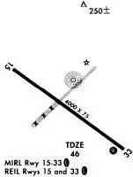
| A81-APT | ACTVT REIL RWY 15 & 33; PAPI RWY 33; MIRL RWY 15/33 - CTAF. |
| E111 | EXISTED PRIOR TO 1959. |
Runways
Runway Summary
| Runways: | 15/33 |
| Longest Runway: | 15/33 is 4002 ft (1220 m) long |
| Runways with an Instrument Approach: |
EPM Seaplane Base Runway Details
| Runway 15/33 | 4002 ft x 75 ft (1220 m x 23 m) | |
| Runway Length Source: | 3RD PARTY SURVEY as of 08/07/2014 | |
| Surface: | Asphalt - Good condition - No special surface treatment | |
| Runway Edge Lights: | Medium Intensity | |
Runway Weight Bearing Capacity (in thousands of pounds) |
||
| Single Wheel Landing Gear: | 30.0 | |
Runway 15 |
Runway 33 |
|
Elevation: |
34.6 | 45.2 |
Latitude: |
44-54-48.1855N | 44-54-24.6796N |
Longitude: |
067-01-08.0248W | 067-00-23.3337W |
|
Runway True Alignment: |
127 | 307 |
Glide Path Angle: |
0.0 degrees | 3.3 degrees |
Traffic Pattern: |
Left | Left |
Runway Markings Type: |
Nonprecision Instrument | Nonprecision Instrument |
Runway Markings Condition: |
Good | Good |
Object at End: |
TREE | |
Object Height: |
12 | |
Object Marked/Lighted?: |
Lighted | |
Distance from End: |
205 | |
Object Centerline Offset: |
75 ft. left of centerline | |
Visual Glide Slope Indicators: |
2-Light PAPI On Left Side Of Runway | |
REIL: |
Yes | Yes |
Touchdown Lights: |
No | No |
Centerline Lights: |
No | No |
Threshold Crossing Height: |
44 |
Services
Airframe Repair: |
None |
Powerplant Repair: |
None |
Fuel Available: |
100LL |
Landing Fees: |
No |
Parking: |
Tiedowns available |
Maps & Diagrams
EPM Sectional
Flight Planning
at skyvector.com
at skyvector.com