
Location
Latitude: |
41-08-20.0436N (41.138901) |
Longitude: |
016-45-38.1564E (16.760599) |
Elevation: |
177 feet MSL (54 m MSL) |
Magnetic Variation: |
4.6 E (as of April 2024 from WMM2020 model) |
Time Zone: |
UTC +1.0 (Standard Time) UTC +2.0 (Daylight Savings Time) |
Contacts
Manager: |
: |
Operations
Airport Status: |
Operational |
Facility Use: |
Public |
Type: |
Airport |
Traffic Pattern Altitude (MSL): |
1177 feet (359 m) |
Based Aircraft
Annual Operations (as of )
Communications
| TWR: | 118.3 |
| APP: | 119.5 |
Fixed Based Operators (FBOs) & Fuel
(Click on a business for detail)
Please help us keep this information up to date. This is a FREE SERVICE just like everything else on Airport Guide! If you see that a business needs to be added, modified, or deleted please fill out our Update Form.
To add, modify, or delete a business click here.
Please help us keep this information up to date. This is a FREE SERVICE just like everything else on Airport Guide! If you see that a business needs to be added, modified, or deleted please fill out our Update Form.
| Business Name | Frequency | Phone | Fuel Grade |
|---|
Flight Service Stations
| Primary | Alternate | |
| FSS on Field: | ||
| FSS Name (ID): | ||
| Frequency: | ||
| Toll Free Phone: |
Instrument Procedures / Charts
Terminal Procedures are only available for airports in several countries with more being added all the time. If you are looking for a specific country's charts, please send an email to support(at)airportguide.com stating the country name. This will be used to prioritize the implementation.
Navigation Aids (Navaids) near BRI
| Dist (NM) | ID | Morse Code | Name | Type | Freq | True Hdg | Mag Hdg |
|---|---|---|---|---|---|---|---|
| 0.8 | BAR | Bari | VOR-DME | 116.40 | 65 | 60 | |
| 4.8 | BPL | Bari | NDB | 401 | 249 | 244 | |
| 21.2 | GIO | Gioia Del Colle | TACAN | 117.80 | 162 | 157 | |
| 21.3 | GIO | Gioia Del Colle | NDB | 328 | 162 | 157 | |
| 46.7 | ORT | Ortanova | TACAN | 114.30 | 289 | 284 | |
| 46.9 | AME | Amendola | NDB | 334 | 297 | 292 | |
| 51.3 | GRT | Grottaglie | NDB | 331 | 143 | 138 | |
| 53.0 | MNL | Amendola | TACAN | 115.25 | 297 | 292 | |
| 56.3 | VIE | Vieste | NDB | 405 | 325 | 320 | |
| 56.4 | VIE | Vieste | VOR-DME | 112.60 | 325 | 320 | |
| 58.1 | FOG | Foggia | VOR | 114.20 | 287 | 283 | |
| 58.1 | FOG | Foggia | NDB | 340 | 287 | 283 | |
| 64.7 | BRD | Brindisi | VORTAC | 113.20 | 118 | 113 | |
| 65.0 | BRD | Brindisi | NDB | 364 | 119 | 114 | |
| 82.1 | LCC | Lecce | VORTAC | 112.80 | 130 | 125 |
Nearby Airports with Fuel
| Dist (NM) | Name (Airport IDs) | True Hdg | Mag Hdg | Fuel Grade |
|---|
Notices to Airmen (NOTAMS)
Remarks
No remarks for this landing facility
Runways
Runway Summary
| Runways: | 07/25 [X] 12/30 |
| Longest Runway: | 07/25 is 9843 ft (3000 m) long |
| Runways with an Instrument Approach: |
BRI Airport Runway Details
| Runway 07/25 | 9843 ft x 148 ft (3000 m x 45 m) | |
| Runway Edge Lights: | Yes Intensity | |
Runway 07 |
Runway 25 |
|
Elevation: |
176 | 108 |
Latitude: |
41.13286209106 | 41.14233398437 |
Longitude: |
16.740627288818 | 16.774084091186 |
|
Runway True Alignment: |
67 | 247 |
Glide Path Angle: |
0.0 degrees | 0.0 degrees |
REIL: |
Yes | Yes |
Threshold Elevation: |
176 | 108 |
Displaced Threshold: |
1234 |
| Runway [X] 12/30 | 512 ft x 164 ft (156 m x 50 m) | |
Runway [X] 12 |
Runway [X] 30 |
|
Elevation: |
108 | 108 |
Latitude: |
41.14429855346 | 41.13629913330 |
Longitude: |
16.779499053955 | 16.796400070190 |
|
Runway True Alignment: |
123 | 303 |
Glide Path Angle: |
0.0 degrees | 0.0 degrees |
Threshold Elevation: |
108 | 108 |
Services
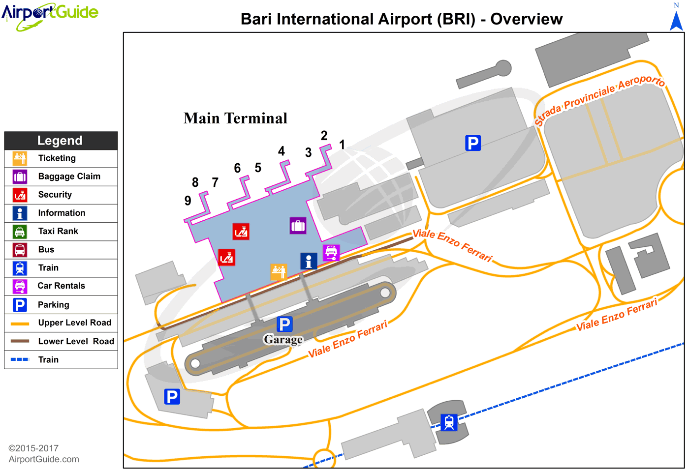
Maps & Diagrams
BRI Sectional
Flight Planning
at skyvector.com
at skyvector.com
